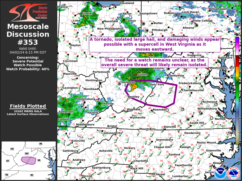
   Mesoscale Discussion 0353
   NWS Storm Prediction Center Norman OK
   0338 PM CDT Tue Apr 02 2024

   Areas affected...Portions of WV into western VA

   Concerning...Severe potential...Watch possible

   Valid 022038Z - 022215Z

   Probability of Watch Issuance...40 percent

   SUMMARY...A tornado, isolated large hail, and damaging winds appear
   possible with a supercell in West Virginia as it moves eastward. The
   need for a watch remains unclear, as the overall severe threat will
   likely remain isolated.

   DISCUSSION...From a large area of disorganized showers and
   thunderstorms, a supercell has recently strengthened across WV. The
   thermodynamic environment across this area remains marginal to
   support robust convection, as earlier thunderstorms and persistent
   cloudiness have hindered destabilization to some extent. Still,
   modest airmass recovery has occurred this afternoon, with latest
   mesoanalysis estimates showing up to 500 J/kg of MLCAPE present
   along/downstream of the ongoing supercell. In addition, recent VWPs
   from KRLX show generally veered, southwesterly low-level flow that
   quickly strengthens with height through mid levels. Even with these
   potentially limiting factors, it appears that a TDS has occurred
   with a recent low-level circulation. In the short term, a tornado
   will remain possible, along with large hail and damaging winds.
   Given the isolated severe threat with just one supercell ongoing,
   the need for a watch downstream remains unclear. Regardless, trends
   will be closely monitored.

   ..Gleason/Thompson.. 04/02/2024

   ...Please see www.spc.noaa.gov for graphic product...

   ATTN...WFO...LWX...RNK...RLX...

   LAT...LON   38468109 38518008 38317870 37607886 37447927 37538015
               37838106 38098130 38468109
|


 @NWSSPC