|
| Mesoscale Discussion 728 |
|
< Previous MD Next MD >
|
|
Mesoscale Discussion 0728
NWS Storm Prediction Center Norman OK
0939 AM CDT Thu May 09 2024
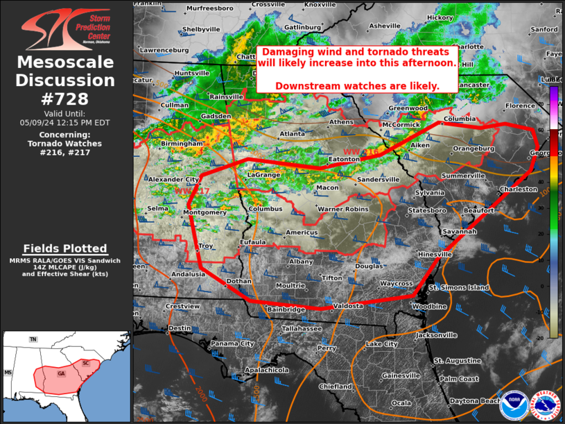
Areas affected...central/eastern SC...central/south GA...southeast
AL
Concerning...Tornado Watch 216...217...
Valid 091439Z - 091615Z
The severe weather threat for Tornado Watch 216, 217 continues.
SUMMARY...Leading convective line across the Savannah Valley may
necessitate an additional downstream watch issuance into the coastal
plain of South Carolina and Georgia in the near-term. Greater severe
potential is expected to evolve from upstream clusters and lines
shifting east-southeast from eastern Alabama, with likely watch
issuance into south Georgia.
DISCUSSION...A leading line of storms across parts of the Savannah
Valley into the SC Midlands has struggled to intensify with measured
gusts holding below 30 mph. However, full boundary-layer heating is
underway downstream to the coast. This coupled with a favorable low
to deep-layer shear environment per CAE VWP data will support
probable intensification of this line as it approaches the coastal
plain through early afternoon. An increase in damaging wind
potential, as well as brief embedded tornadoes may occur.
More prominent severe potential should emanate out of initially
semi-discrete supercells across parts of south AL spreading east of
the Chattahoochee River into GA, as well as an organized linear
cluster moving southeast from east-central AL. It appears likely
that further upscale growth will occur into this afternoon, yielding
a broader linear cluster/QLCS pushing southeast across much of
central and south GA.
..Grams.. 05/09/2024
...Please see www.spc.noaa.gov for graphic product...
ATTN...WFO...ILM...CHS...CAE...JAX...FFC...TAE...BMX...
LAT...LON 34028110 33908025 33977974 33857919 33557909 33157926
31708116 31078167 30868350 30988488 31518587 32598617
33098591 33388499 33248352 33478229 34028110
|
|
Top/All Mesoscale Discussions/Forecast Products/Home
|
|


 @NWSSPC