|
| Mesoscale Discussion 729 |
|
< Previous MD Next MD >
|
|
Mesoscale Discussion 0729
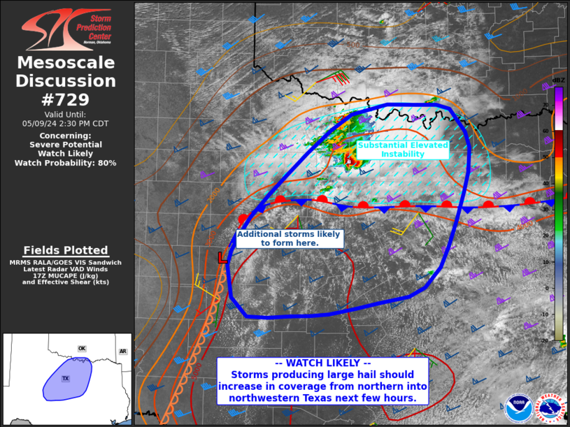
NWS Storm Prediction Center Norman OK
1210 PM CDT Thu May 09 2024
Areas affected...much of northwest into northern Texas and toward
the Red River
Concerning...Severe potential...Watch likely
Valid 091710Z - 091930Z
CORRECTED FOR WORDING
Probability of Watch Issuance...80 percent
SUMMARY...Storms are expected to increase in coverage through the
afternoon, with very large hail possible from northwest into
northern Texas. Damaging winds will also be possible.
DISCUSSION...Surface analysis shows a stationary front extending
from near Shreveport LA westward across the Metroplex and toward a
weak surface low near San Angelo, TX. The air mass is very moist and
unstable across the entire region, as can be seen from the 12Z FWD
sounding where elevated MUCAPE north of the boundary is around 4000
J/kg with steep midlevel lapse rates.
Further indicative of the quality of the elevated instability north
of the front are robust cells already forming over Young and Archer
Counties, which are situated atop relatively cool/dry surface
northeasterlies. Deep-layer shear may be effectively augmented for
cells moving eastward along the boundary later today as the air mass
along it heats, with around 60 kt shear. Severe cells are also
expected to form near the weak surface low or close to the
dryline/stationary front intersection, with both very large hail and
damaging winds as storms increase in coverage.
..Jewell/Smith.. 05/09/2024
...Please see www.spc.noaa.gov for graphic product...
ATTN...WFO...FWD...OUN...SJT...
LAT...LON 32829971 33919838 34049730 33989676 33669652 33129647
31819694 31429746 31329796 31189874 31159934 31140004
31390029 31830036 32260018 32829971
|
|
Top/All Mesoscale Discussions/Forecast Products/Home
|
|


 @NWSSPC