|
| Mesoscale Discussion 782 |
|
< Previous MD Next MD >
|
|
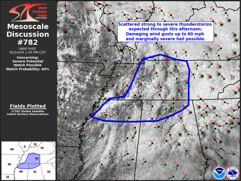
   Mesoscale Discussion 0782
   NWS Storm Prediction Center Norman OK
   1244 PM CDT Tue May 14 2024

   Areas affected...Portions of Middle Tennessee...far northern
   Mississippi...and northern Alabama

   Concerning...Severe potential...Watch possible

   Valid 141744Z - 141845Z

   Probability of Watch Issuance...40 percent

   SUMMARY...Scattered thunderstorms will continue to develop over the
   next 1-3 hours across portions of Middle Tennessee and northern
   Alabama. A few severe thunderstorms are expected with a localized
   threat of damaging winds near 60 mph and occasional large hail 1 to
   1.5 inches in diameter.

   DISCUSSION...A broken line of scattered thunderstorms has developed
   along a surface trough/weak cold front this afternoon from far
   northwest MS through portions of western TN. Recent visible
   satellite imagery indicates stratus is beginning to mix out
   downstream of an approaching mid to upper level vorticity maximum,
   currently located over northwest MS. As this feature continues to
   progress eastward, additional thunderstorms are expected to develop.
   Dewpoints in the mid 60s and temperatures in the low to mid 70s
   under marginal mid level lapse rates are currently yielding around
   1000 J/kg of MLCAPE under effective deep layer shear near 30 kt. A
   slight improvement to the thermodynamic environment is expected
   through this afternoon as destabilization continues, steeper lapse
   rates slowly advect northeastward, and cooler temperatures aloft
   move overhead. This may be especially true within pockets of
   clearing. Multicells with clusters, and perhaps some bowing
   segments, will be possible in addition to a few supercells more
   likely later in the afternoon. Localized damaging wind gusts near 60
   mph and large hail up to 1.5 inches in diameter may accompany the
   more robust updrafts. Conditions will be monitored for a possible
   severe thunderstorm watch.

   ..Barnes/Gleason/Thompson.. 05/14/2024

   ...Please see www.spc.noaa.gov for graphic product...

   ATTN...WFO...MRX...LMK...OHX...BMX...HUN...PAH...MEG...

   LAT...LON   34269063 34579029 34769009 35038977 35158899 35658867
               36328833 36698810 36878719 36658634 36598586 36228572
               35818577 35168579 34778580 34558615 34408654 34138735
               34098876 34129000 34269063
|
|
Top/All Mesoscale Discussions/Forecast Products/Home
|
|


 @NWSSPC