|
| Mesoscale Discussion 799 |
|
< Previous MD Next MD >
|
|
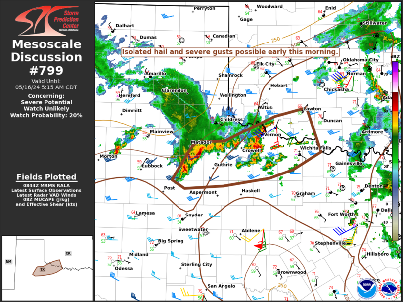
   Mesoscale Discussion 0799
   NWS Storm Prediction Center Norman OK
   0346 AM CDT Thu May 16 2024

   Areas affected...Parts of the TX South Plains into western north TX
   and southwest OK

   Concerning...Severe potential...Watch unlikely

   Valid 160846Z - 161015Z

   Probability of Watch Issuance...20 percent

   SUMMARY...The threat for isolated hail and localized strong/damaging
   gusts may persist through the overnight hours.

   DISCUSSION...A small thunderstorm cluster, which has produced a few
   severe gusts within the West Texas Mesonet, is moving east of
   Lubbock early this morning. This cluster continues to show some
   organization, with notable pressure rises in its wake, and isolated
   severe gusts will remain possible as it continues to move eastward
   within a modestly favorable environment.

   Other strong cells have developed in a band extending east from the
   cluster, with golfball-size hail recently reported in Wilbarger
   County. While this convection is elevated atop a relatively
   cool/stable near-surface layer, MUCAPE of around 1000 J/kg and
   sufficient effective shear could support maintenance or some
   intensification of these ongoing storms in the hours prior to
   sunrise. Relatively steep midlevel lapse rates will support an
   isolated hail threat, while rather dry subcloud layers could support
   a continued threat for localized strong to severe gusts.

   ..Dean/Guyer.. 05/16/2024

   ...Please see www.spc.noaa.gov for graphic product...

   ATTN...WFO...OUN...SJT...LUB...

   LAT...LON   33990078 34070065 34100008 34269968 34539899 34699831
               33899802 33599862 33439912 33300010 33250092 33390118
               33990078
|
|
Top/All Mesoscale Discussions/Forecast Products/Home
|
|


 @NWSSPC