|
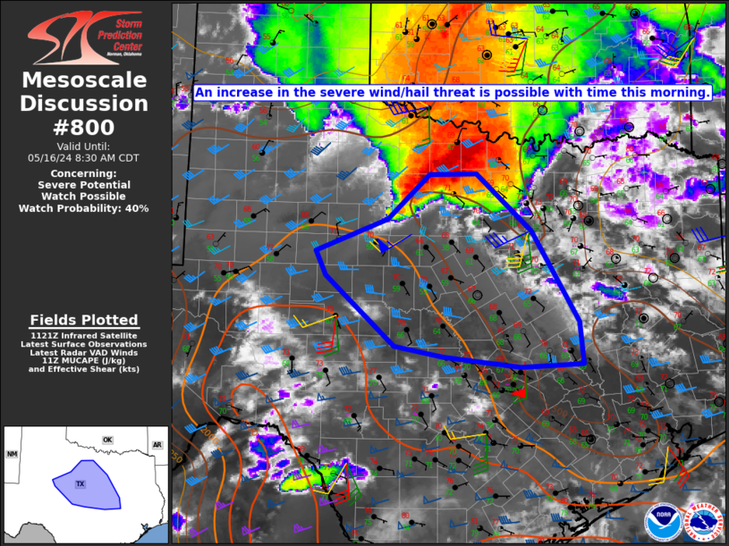
| Mesoscale Discussion 800 |
|
< Previous MD Next MD >
|
|
   Mesoscale Discussion 0800
   NWS Storm Prediction Center Norman OK
   0628 AM CDT Thu May 16 2024

   Areas affected...Parts of northwest into central TX

   Concerning...Severe potential...Watch possible

   Valid 161128Z - 161330Z

   Probability of Watch Issuance...40 percent

   SUMMARY...An increase in the severe wind/hail threat is possible
   through the morning. Watch issuance is possible, though timing is
   uncertain.

   DISCUSSION...A long-lived storm cluster and its attendant cold pool
   have begun propagating more to the southeast this morning across
   northwest TX, with occasional strong to severe gusts noted along the
   gust front. Meanwhile, rich low-level moisture currently confined to
   from the Edwards Plateau region into central/south TX is expected to
   quickly advect northward through the morning, aided by a southerly
   low-level jet. This could eventually lead to renewed storm
   development along and north of the southeastward-moving outflow, as
   MUCAPE increases to near/above 2000 J/kg.

   While convection through much of the morning will likely remain
   somewhat elevated, gradually increasing midlevel flow in advance of
   an approaching shortwave trough will support sufficient effective
   shear for storm organization. An elevated supercell or two will be
   possible, with an attendant threat of hail and localized severe
   gusts. Some additional upscale growth will be possible, with an MCS
   potentially propagating southeastward along the instability gradient
   later today.

   A more substantial severe threat is expected later today across
   parts of central TX. Onset/timing of the higher-end severe potential
   remains somewhat uncertain, but watch issuance will become
   increasingly possible through the morning.

   ..Dean/Guyer.. 05/16/2024

   ...Please see www.spc.noaa.gov for graphic product...

   ATTN...WFO...HGX...FWD...EWX...SJT...MAF...

   LAT...LON   32589723 31279645 30689639 30639743 30789872 30949953
               31940068 32280084 32759964 33399894 33399815 32589723
|
|
Top/All Mesoscale Discussions/Forecast Products/Home
|
|


 @NWSSPC