|
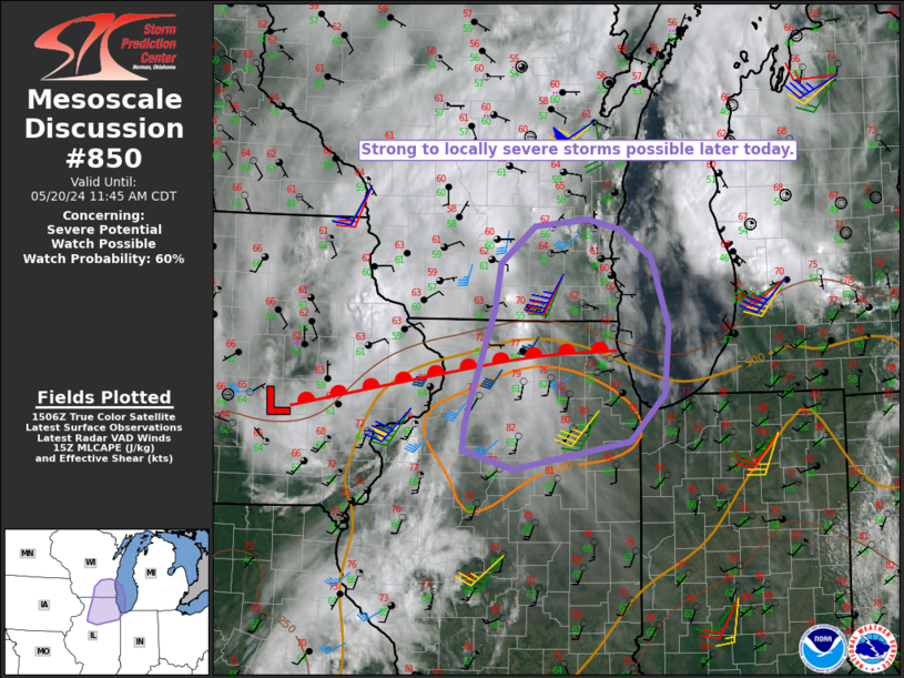
| Mesoscale Discussion 850 |
|
< Previous MD Next MD >
|
|
   Mesoscale Discussion 0850
   NWS Storm Prediction Center Norman OK
   1013 AM CDT Mon May 20 2024

   Areas affected...Northern IL into southeast WI

   Concerning...Severe potential...Watch possible

   Valid 201513Z - 201645Z

   Probability of Watch Issuance...60 percent

   SUMMARY...Strong to locally severe storms are possible later today.

   DISCUSSION...An MCV and related surface reflection are moving
   east-northeastward across eastern IA this morning. This feature is
   expected to track along a warm frontal zone that is moving northward
   from northern IL into southern WI. Along/south of the warm front,
   diurnal heating of a relatively moist environment will result in
   moderate destabilization, with MLCAPE expected to increase above
   1500 J/kg by late morning/early afternoon. As this occurs, a zone of
   stronger low/midlevel flow associated with the MCV will move across
   the effective warm sector, resulting in a conditionally favorable
   environment for organized convection.

   While most convection has been focused north of the warm front
   through the morning, storm development appears imminent closer to
   the warm front from far southern WI into northern IL. Stronger
   storms, including the potential for organized clusters and a couple
   supercells, are expected to develop from late morning into early
   afternoon. Low-level shear/SRH will be sufficient to support a
   couple tornadoes if supercells can be sustained within this regime.
   Otherwise, damaging gusts and hail may accompany the stronger
   storms. Watch issuance is possible if trends continue to support
   storm development across the warm sector late this morning.

   ..Dean/Hart.. 05/20/2024

   ...Please see www.spc.noaa.gov for graphic product...

   ATTN...WFO...LOT...ILX...MKX...DVN...

   LAT...LON   41288765 41008921 41198988 41468985 41668979 42618947
               43078938 43448892 43508820 43418778 43138735 42428713
               41768719 41288765
|
|
Top/All Mesoscale Discussions/Forecast Products/Home
|
|


 @NWSSPC