|
| Mesoscale Discussion 858 |
|
< Previous MD Next MD >
|
|
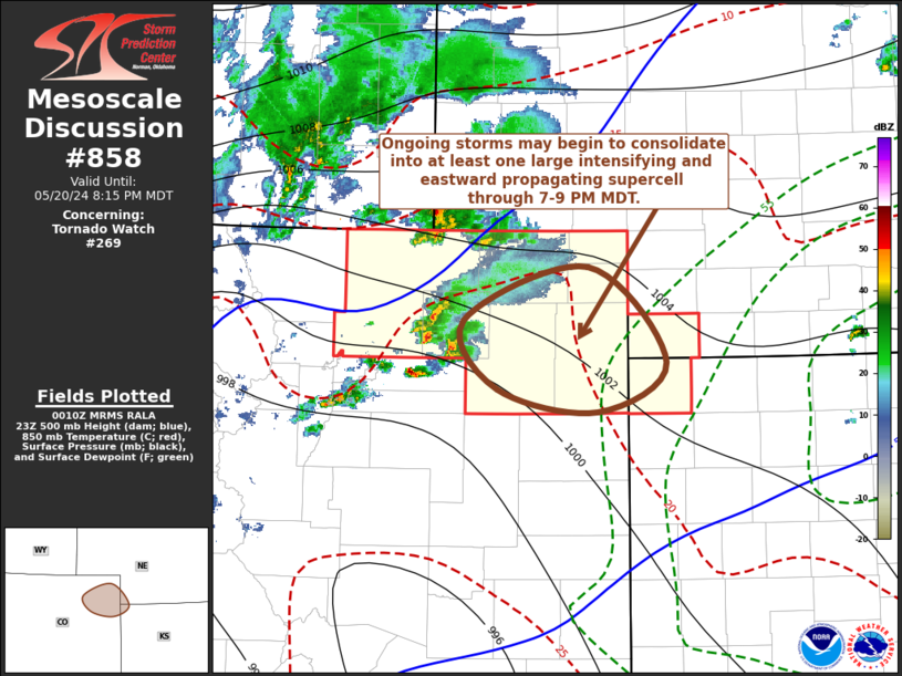
   Mesoscale Discussion 0858
   NWS Storm Prediction Center Norman OK
   0713 PM CDT Mon May 20 2024

   Areas affected...parts of  northeastern Colorado

   Concerning...Tornado Watch 269...

   Valid 210013Z - 210215Z

   The severe weather threat for Tornado Watch 269 continues.

   SUMMARY...Ongoing thunderstorms may begin to consolidate into at
   least one increasingly prominent supercell across and east of the
   Akron CO vicinity of northeastern Colorado through 7-9 PM MDT.  This
   may be accompanied by a risk for large hail in excess of 2 inches in
   diameter, locally damaging wind gusts and increasing potential for a
   tornado or two.

   DISCUSSION...Thunderstorms development has been slowly increasing to
   the north of the Palmer Ridge, with intensification initially slowed
   by rather modest boundary-layer instability.  Downstream of
   large-scale mid-level troughing crossing the Intermountain West,
   cyclogenesis is underway to the lee of the southern Rockies.  A
   corridor of strengthening warm advection centered around around the
   700 mb level is becoming focused across northeastern Colorado into
   southwestern Nebraska, and associated forcing for ascent may
   contribute to consolidation of ongoing storms approaching areas
   near/northwest of Akron CO through 01-03Z.  At the same time,
   continued boundary-layer moistening on easterly low-level flow
   beneath steepening lapse rates may contribute to mixed-layer CAPE
   increasing in excess of 1000-1500 J/kg.

   Vertical shear beneath a strong west-southwesterly jet nosing across
   the southern Rockies into the central Great Plains will support
   substantive intensification as inflow into convection becomes
   increasingly unstable.  It seems probable that this will include the
   evolution of at least one prominent supercell, which may tend to
   remain focused along the baroclinic zone as it propagates eastward
   within 30+ kt southwesterly deep-layer ambient mean flow.

   ..Kerr.. 05/21/2024

   ...Please see www.spc.noaa.gov for graphic product...

   ATTN...WFO...GLD...BOU...

   LAT...LON   40300373 40720246 39970166 39580236 39750338 40300373
|
|
Top/All Mesoscale Discussions/Forecast Products/Home
|
|


 @NWSSPC