Note:
The expiration time in the watch graphic is amended if the watch is
replaced, cancelled or extended.
Note:
Note:
The expiration time in the watch graphic is amended if the watch is
replaced, cancelled or extended.
Note: Click for
Watch Status Reports.
SEL9
URGENT - IMMEDIATE BROADCAST REQUESTED
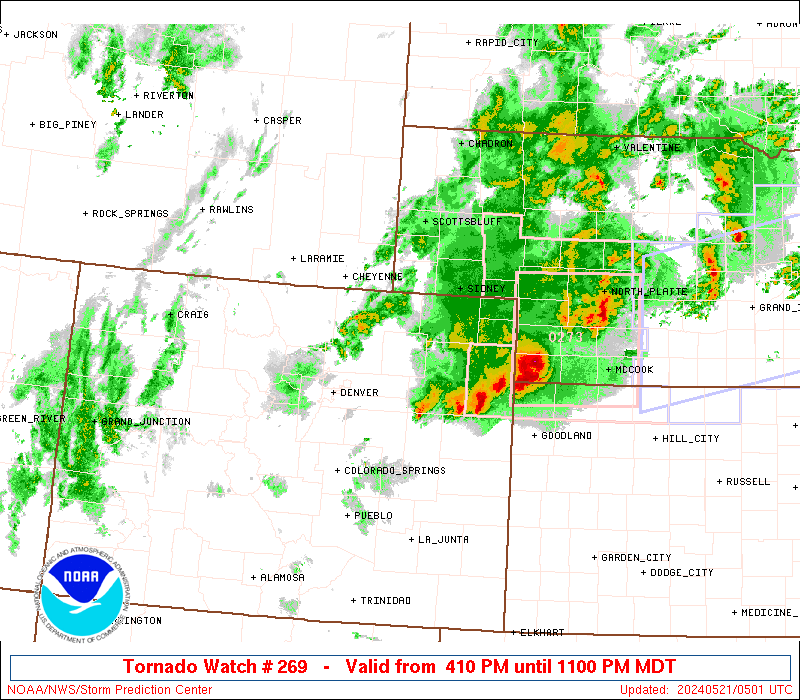
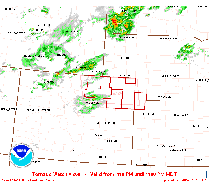
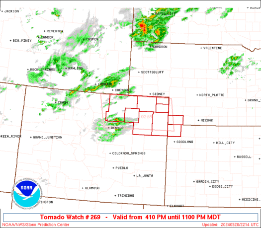
Tornado Watch Number 269
NWS Storm Prediction Center Norman OK
410 PM MDT Mon May 20 2024
The NWS Storm Prediction Center has issued a
* Tornado Watch for portions of
Northeast Colorado
Extreme northwest Kansas
Extreme southwest Nebraska
* Effective this Monday afternoon and evening from 410 PM until
1100 PM MDT.
* Primary threats include...
A couple tornadoes possible
Scattered large hail and isolated very large hail events to 2.5
inches in diameter likely
Scattered damaging wind gusts to 70 mph possible
SUMMARY...A few supercells are expected to form this evening across
northeast CO, and the storms will then move east-northeastward
toward extreme southwest Nebraska and northwest Kansas through late
evening/early tonight. Very large hail to 2.5 inches in diameter
and severe gusts of 60-70 mph will be the main threats, though a
gradual increase in low-level moisture later this evening will
support the potential for a couple of tornadoes.
The tornado watch area is approximately along and 90 statute miles
east and west of a line from 60 miles north northwest of Akron CO to
30 miles south southwest of Akron CO. For a complete depiction of
the watch see the associated watch outline update (WOUS64 KWNS
WOU9).
PRECAUTIONARY/PREPAREDNESS ACTIONS...
REMEMBER...A Tornado Watch means conditions are favorable for
tornadoes and severe thunderstorms in and close to the watch
area. Persons in these areas should be on the lookout for
threatening weather conditions and listen for later statements
and possible warnings.
&&
OTHER WATCH INFORMATION...CONTINUE...WW 268...
AVIATION...Tornadoes and a few severe thunderstorms with hail
surface and aloft to 2.5 inches. Extreme turbulence and surface wind
gusts to 60 knots. A few cumulonimbi with maximum tops to 450. Mean
storm motion vector 26025.
...Thompson
   SEL9

   URGENT - IMMEDIATE BROADCAST REQUESTED
   Tornado Watch Number 269
   NWS Storm Prediction Center Norman OK
   410 PM MDT Mon May 20 2024

   The NWS Storm Prediction Center has issued a

   * Tornado Watch for portions of
     Northeast Colorado
     Extreme northwest Kansas
     Extreme southwest Nebraska

   * Effective this Monday afternoon and evening from 410 PM until
     1100 PM MDT.

   * Primary threats include...
     A couple tornadoes possible
     Scattered large hail and isolated very large hail events to 2.5
       inches in diameter likely
     Scattered damaging wind gusts to 70 mph possible

   SUMMARY...A few supercells are expected to form this evening across
   northeast CO, and the storms will then move east-northeastward
   toward extreme southwest Nebraska and northwest Kansas through late
   evening/early tonight.  Very large hail to 2.5 inches in diameter
   and severe gusts of 60-70 mph will be the main threats, though a
   gradual increase in low-level moisture later this evening will
   support the potential for a couple of tornadoes.

   The tornado watch area is approximately along and 90 statute miles
   east and west of a line from 60 miles north northwest of Akron CO to
   30 miles south southwest of Akron CO. For a complete depiction of
   the watch see the associated watch outline update (WOUS64 KWNS
   WOU9).

   PRECAUTIONARY/PREPAREDNESS ACTIONS...

   REMEMBER...A Tornado Watch means conditions are favorable for
   tornadoes and severe thunderstorms in and close to the watch
   area. Persons in these areas should be on the lookout for
   threatening weather conditions and listen for later statements
   and possible warnings.

   &&

   OTHER WATCH INFORMATION...CONTINUE...WW 268...

   AVIATION...Tornadoes and a few severe thunderstorms with hail
   surface and aloft to 2.5 inches. Extreme turbulence and surface wind
   gusts to 60 knots. A few cumulonimbi with maximum tops to 450. Mean
   storm motion vector 26025.

   ...Thompson
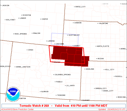 Note:
The Aviation Watch (SAW) product is an approximation to the watch area.
The actual watch is depicted by the shaded areas.
Note:
The Aviation Watch (SAW) product is an approximation to the watch area.
The actual watch is depicted by the shaded areas.
   SAW9
   WW 269 TORNADO CO KS NE 202210Z - 210500Z
   AXIS..90 STATUTE MILES EAST AND WEST OF LINE..
   60NNW AKO/AKRON CO/ - 30SSW AKO/AKRON CO/
   ..AVIATION COORDS.. 80NM E/W /32WSW SNY - 26SSW AKO/
   HAIL SURFACE AND ALOFT..2.5 INCHES. WIND GUSTS..60 KNOTS.
   MAX TOPS TO 450. MEAN STORM MOTION VECTOR 26025.

   LAT...LON 40970194 39770174 39770513 40970539

   THIS IS AN APPROXIMATION TO THE WATCH AREA.  FOR A
   COMPLETE DEPICTION OF THE WATCH SEE WOUS64 KWNS
   FOR WOU9.
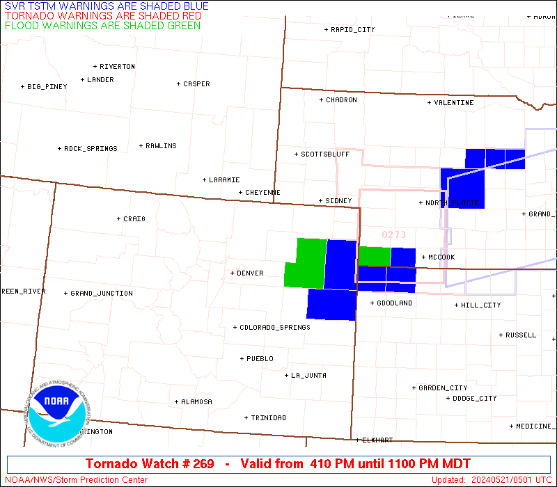
Watch 269 Status Report Messages:
STATUS REPORT #3 ON WW 269

VALID 210440Z - 210500Z

SEVERE WEATHER THREAT CONTINUES RIGHT OF A LINE FROM 25 SSW AKO
TO 10 SW AKO TO 10 W IML.

REMAINING VALID PORTION OF WW 269 MAY BE ALLOWED TO EXPIRE AT
21/05Z.
..KERR..05/21/24

ATTN...WFO...BOU...GLD...

&&

STATUS REPORT FOR WT 269

SEVERE WEATHER THREAT CONTINUES FOR THE FOLLOWING AREAS

COC121-210500-

CO
.    COLORADO COUNTIES INCLUDED ARE

WASHINGTON
$$


THE WATCH STATUS MESSAGE IS FOR GUIDANCE PURPOSES ONLY.  PLEASE
REFER TO WATCH COUNTY NOTIFICATION STATEMENTS FOR OFFICIAL
INFORMATION ON COUNTIES...INDEPENDENT CITIES AND MARINE ZONES
CLEARED FROM SEVERE THUNDERSTORM AND TORNADO WATCHES.
$$

STATUS REPORT #2 ON WW 269

VALID 210230Z - 210340Z

SEVERE WEATHER THREAT CONTINUES RIGHT OF A LINE FROM 15 E DEN TO
35 WNW AKO TO 10 SW SNY.

..KERR..05/21/24

ATTN...WFO...BOU...GLD...

&&

STATUS REPORT FOR WT 269

SEVERE WEATHER THREAT CONTINUES FOR THE FOLLOWING AREAS

COC075-087-095-115-121-210340-

CO
.    COLORADO COUNTIES INCLUDED ARE

LOGAN		     MORGAN		 PHILLIPS
SEDGWICK	     WASHINGTON
$$


THE WATCH STATUS MESSAGE IS FOR GUIDANCE PURPOSES ONLY.  PLEASE
REFER TO WATCH COUNTY NOTIFICATION STATEMENTS FOR OFFICIAL
INFORMATION ON COUNTIES...INDEPENDENT CITIES AND MARINE ZONES
CLEARED FROM SEVERE THUNDERSTORM AND TORNADO WATCHES.
$$

STATUS REPORT #1 ON WW 269

VALID 210135Z - 210240Z

THE SEVERE WEATHER THREAT CONTINUES ACROSS THE ENTIRE WATCH AREA.

..KERR..05/21/24

ATTN...WFO...BOU...GLD...

&&

STATUS REPORT FOR WT 269

SEVERE WEATHER THREAT CONTINUES FOR THE FOLLOWING AREAS

COC075-087-095-115-121-123-125-210240-

CO
.    COLORADO COUNTIES INCLUDED ARE

LOGAN		     MORGAN		 PHILLIPS
SEDGWICK	     WASHINGTON 	 WELD
YUMA
$$


KSC023-210240-

KS
.    KANSAS COUNTIES INCLUDED ARE

CHEYENNE
$$


NEC057-210240-

NE
.    NEBRASKA COUNTIES INCLUDED ARE

DUNDY
$$


THE WATCH STATUS MESSAGE IS FOR GUIDANCE PURPOSES ONLY.  PLEASE
REFER TO WATCH COUNTY NOTIFICATION STATEMENTS FOR OFFICIAL
INFORMATION ON COUNTIES...INDEPENDENT CITIES AND MARINE ZONES
CLEARED FROM SEVERE THUNDERSTORM AND TORNADO WATCHES.
$$
Note:
Click for Complete Product Text.
Tornadoes
Probability of 2 or more tornadoes
|
Mod (40%)
|
Probability of 1 or more strong (EF2-EF5) tornadoes
|
Low (20%)
|
Wind
Probability of 10 or more severe wind events
|
Mod (50%)
|
Probability of 1 or more wind events > 65 knots
|
Low (20%)
|
Hail
Probability of 10 or more severe hail events
|
Mod (60%)
|
Probability of 1 or more hailstones > 2 inches
|
Mod (60%)
|
Combined Severe Hail/Wind
Probability of 6 or more combined severe hail/wind events
|
High (90%)
|
For each watch, probabilities for particular events inside the watch
(listed above in each table) are determined by the issuing forecaster.
The "Low" category contains probability values ranging from less than 2%
to 20% (EF2-EF5 tornadoes), less than 5% to 20% (all other probabilities),
"Moderate" from 30% to 60%, and "High" from 70% to greater than 95%.
High values are bolded and lighter in color to provide awareness of
an increased threat for a particular event.


 @NWSSPC