|
| Mesoscale Discussion 882 |
|
< Previous MD Next MD >
|

|
   Mesoscale Discussion 0882
   NWS Storm Prediction Center Norman OK
   0755 PM CDT Tue May 21 2024

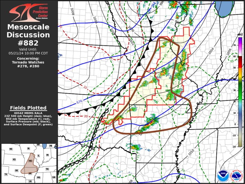
   Areas affected...parts of west central Illinois and northeastern
   through southwestern Missouri..northeastern Oklahoma and
   northwestern Arkansas

   Concerning...Tornado Watch 278...280...

   Valid 220055Z - 220300Z

   The severe weather threat for Tornado Watch 278, 280 continues.

   SUMMARY...Stronger thunderstorm development, including a few
   supercells, may become increasingly confined to portions of
   northeastern Oklahoma and northern Arkansas/adjacent southern
   Missouri through 9-11 PM CDT.  A new severe weather watch may be
   needed across parts of northern Arkansas soon.

   DISCUSSION...The cold front appears to have overtaken the dryline
   across western into central Missouri and northeastern Oklahoma, with
   little appreciable increase in thunderstorm development.  Widely
   scattered strong storms persist, including a few  supercells, but an
   initial corridor of drier/more stable air across parts of south
   central and east central Missouri into west central Illinois remains
   a complicating factor for maintenance of this activity through mid
   to late evening.

   A more recent flare-up of convection immediately to the southwest
   through northwest of St. Louis may have been aided by weakening
   inhibition associated with leading edge of mid-level cooling near
   the eastern periphery of the corridor of drier air, further
   complicating  the maintenance of strong convection beyond the next
   hour or two.

   Strongest thunderstorm development may begin to become focused ahead
   of the southeastward advancing cold front, on the southern periphery
   of the cyclonic mid-level flow and east of the dryline, across
   northeastern Oklahoma and northern Arkansas through 9-11 PM.  This
   may include a few supercells accompanied by a risk for severe hail,
   locally strong surface gusts and potential for a tornado or two.

   ..Kerr.. 05/22/2024

   ...Please see www.spc.noaa.gov for graphic product...

   ATTN...WFO...PAH...MEG...LSX...DVN...LZK...SGF...EAX...TSA...

   LAT...LON   40539230 40069086 39989081 37589146 37109112 36609007
               35289056 34749480 35429576 36679464 39489283 40539230
|
|
Top/All Mesoscale Discussions/Forecast Products/Home
|
|


