 Note:
The expiration time in the watch graphic is amended if the watch is
replaced, cancelled or extended.
Note:
Note:
The expiration time in the watch graphic is amended if the watch is
replaced, cancelled or extended.
Note: Click for
Watch Status Reports.
SEL0
URGENT - IMMEDIATE BROADCAST REQUESTED
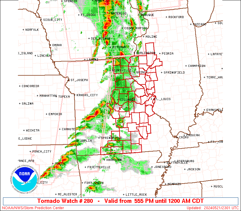
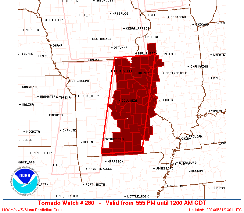
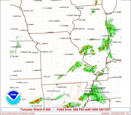
Tornado Watch Number 280
NWS Storm Prediction Center Norman OK
555 PM CDT Tue May 21 2024
The NWS Storm Prediction Center has issued a
* Tornado Watch for portions of
West central Illinois
Eastern into south central Missouri
* Effective this Tuesday afternoon from 555 PM until Midnight
CDT.
* Primary threats include...
A few tornadoes likely with a couple intense tornadoes possible
Scattered damaging winds likely with isolated significant gusts
to 75 mph possible
Scattered large hail likely with isolated very large hail events
to 2 inches in diameter possible
SUMMARY...Scattered supercells and short line segments will remain
possible through late evening in a broken band spreading eastward
across Missouri toward west central Illinois. The more intense
storms will be capable of producing a few tornadoes (one or two of
which could be strong), large hail of 1-2 inches in diameter, and
damaging gusts of 60-75 mph.
The tornado watch area is approximately along and 60 statute miles
east and west of a line from 50 miles north of Quincy IL to 25 miles
west southwest of West Plains MO. For a complete depiction of the
watch see the associated watch outline update (WOUS64 KWNS WOU0).
PRECAUTIONARY/PREPAREDNESS ACTIONS...
REMEMBER...A Tornado Watch means conditions are favorable for
tornadoes and severe thunderstorms in and close to the watch
area. Persons in these areas should be on the lookout for
threatening weather conditions and listen for later statements
and possible warnings.
&&
OTHER WATCH INFORMATION...CONTINUE...WW 277...WW 278...WW 279...
AVIATION...Tornadoes and a few severe thunderstorms with hail
surface and aloft to 2 inches. Extreme turbulence and surface wind
gusts to 65 knots. A few cumulonimbi with maximum tops to 500. Mean
storm motion vector 25035.
...Thompson

   SEL0

   URGENT - IMMEDIATE BROADCAST REQUESTED
   Tornado Watch Number 280
   NWS Storm Prediction Center Norman OK
   555 PM CDT Tue May 21 2024

   The NWS Storm Prediction Center has issued a

   * Tornado Watch for portions of
     West central Illinois
     Eastern into south central Missouri

   * Effective this Tuesday afternoon from 555 PM until Midnight
     CDT.

   * Primary threats include...
     A few tornadoes likely with a couple intense tornadoes possible
     Scattered damaging winds likely with isolated significant gusts
       to 75 mph possible
     Scattered large hail likely with isolated very large hail events
       to 2 inches in diameter possible

   SUMMARY...Scattered supercells and short line segments will remain
   possible through late evening in a broken band spreading eastward
   across Missouri toward west central Illinois.  The more intense
   storms will be capable of producing a few tornadoes (one or two of
   which could be strong), large hail of 1-2 inches in diameter, and
   damaging gusts of 60-75 mph.

   The tornado watch area is approximately along and 60 statute miles
   east and west of a line from 50 miles north of Quincy IL to 25 miles
   west southwest of West Plains MO. For a complete depiction of the
   watch see the associated watch outline update (WOUS64 KWNS WOU0).

   PRECAUTIONARY/PREPAREDNESS ACTIONS...

   REMEMBER...A Tornado Watch means conditions are favorable for
   tornadoes and severe thunderstorms in and close to the watch
   area. Persons in these areas should be on the lookout for
   threatening weather conditions and listen for later statements
   and possible warnings.

   &&

   OTHER WATCH INFORMATION...CONTINUE...WW 277...WW 278...WW 279...

   AVIATION...Tornadoes and a few severe thunderstorms with hail
   surface and aloft to 2 inches. Extreme turbulence and surface wind
   gusts to 65 knots. A few cumulonimbi with maximum tops to 500. Mean
   storm motion vector 25035.

   ...Thompson
 Note:
The Aviation Watch (SAW) product is an approximation to the watch area.
The actual watch is depicted by the shaded areas.
Note:
The Aviation Watch (SAW) product is an approximation to the watch area.
The actual watch is depicted by the shaded areas.
   SAW0
   WW 280 TORNADO IL MO 212255Z - 220500Z
   AXIS..60 STATUTE MILES EAST AND WEST OF LINE..
   50N UIN/QUINCY IL/ - 25WSW UNO/WEST PLAINS MO/
   ..AVIATION COORDS.. 50NM E/W /50N UIN - 67SE SGF/
   HAIL SURFACE AND ALOFT..2 INCHES. WIND GUSTS..65 KNOTS.
   MAX TOPS TO 500. MEAN STORM MOTION VECTOR 25035.

   LAT...LON 40669006 36619120 36619337 40669234

   THIS IS AN APPROXIMATION TO THE WATCH AREA.  FOR A
   COMPLETE DEPICTION OF THE WATCH SEE WOUS64 KWNS
   FOR WOU0.
Watch 280 Status Report Messages:
STATUS REPORT #5 ON WW 280
VALID 220230Z - 220340Z
SEVERE WEATHER THREAT CONTINUES RIGHT OF A LINE FROM 25 WNW FAM
TO 15 SW TBN TO 30 WNW TBN TO 45 NNE VIH TO 20 WNW STL TO 20 N
STL.
REMAINING VALID PORTION OF WW MAY BE CANCELLED AROUND 03Z, IF
CURRENT CONVECTIVE TRENDS CONTINUE.
..KERR..05/22/24
ATTN...WFO...LSX...ILX...DVN...SGF...
&&
STATUS REPORT FOR WT 280
SEVERE WEATHER THREAT CONTINUES FOR THE FOLLOWING AREAS
ILC095-220340-
IL
. ILLINOIS COUNTIES INCLUDED ARE
KNOX
$$
MOC055-071-073-099-125-161-169-183-189-215-219-221-510-220340-
MO
. MISSOURI COUNTIES INCLUDED ARE
CRAWFORD FRANKLIN GASCONADE
JEFFERSON MARIES PHELPS
PULASKI ST. CHARLES ST. LOUIS
TEXAS WARREN WASHINGTON
MISSOURI INDEPENDENT CITIES INCLUDED ARE
ST. LOUIS CITY
$$
THE WATCH STATUS MESSAGE IS FOR GUIDANCE PURPOSES ONLY. PLEASE
REFER TO WATCH COUNTY NOTIFICATION STATEMENTS FOR OFFICIAL
INFORMATION ON COUNTIES...INDEPENDENT CITIES AND MARINE ZONES
CLEARED FROM SEVERE THUNDERSTORM AND TORNADO WATCHES.
$$
STATUS REPORT #4 ON WW 280
VALID 220230Z - 220340Z
SEVERE WEATHER THREAT CONTINUES RIGHT OF A LINE FROM 25 WNW FAM
TO 15 SW TBN TO 30 WNW TBN TO 45 NNE VIH TO 20 WNW STL TO 20 N
STL.
..KERR..05/22/24
ATTN...WFO...LSX...ILX...DVN...SGF...
&&
STATUS REPORT FOR WT 280
SEVERE WEATHER THREAT CONTINUES FOR THE FOLLOWING AREAS
ILC095-220340-
IL
. ILLINOIS COUNTIES INCLUDED ARE
KNOX
$$
MOC055-071-073-099-125-161-169-183-189-215-219-221-510-220340-
MO
. MISSOURI COUNTIES INCLUDED ARE
CRAWFORD FRANKLIN GASCONADE
JEFFERSON MARIES PHELPS
PULASKI ST. CHARLES ST. LOUIS
TEXAS WARREN WASHINGTON
MISSOURI INDEPENDENT CITIES INCLUDED ARE
ST. LOUIS CITY
$$
THE WATCH STATUS MESSAGE IS FOR GUIDANCE PURPOSES ONLY. PLEASE
REFER TO WATCH COUNTY NOTIFICATION STATEMENTS FOR OFFICIAL
INFORMATION ON COUNTIES...INDEPENDENT CITIES AND MARINE ZONES
CLEARED FROM SEVERE THUNDERSTORM AND TORNADO WATCHES.
$$
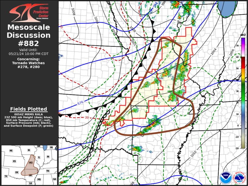
STATUS REPORT #3 ON WW 280
VALID 220135Z - 220240Z
SEVERE WEATHER THREAT CONTINUES RIGHT OF A LINE FROM 45 SW JEF TO
10 SW COU TO 30 ESE IRK TO 10 SSW BRL.
FOR ADDITIONAL INFORMATION SEE MESOSCALE DISCUSSION 882.
..KERR..05/22/24
ATTN...WFO...LSX...ILX...DVN...SGF...
&&
STATUS REPORT FOR WT 280
SEVERE WEATHER THREAT CONTINUES FOR THE FOLLOWING AREAS
ILC001-009-013-017-057-061-067-083-095-109-125-137-149-169-171-
220240-
IL
. ILLINOIS COUNTIES INCLUDED ARE
ADAMS BROWN CALHOUN
CASS FULTON GREENE
HANCOCK JERSEY KNOX
MCDONOUGH MASON MORGAN
PIKE SCHUYLER SCOTT
$$
MOC007-027-055-065-067-071-073-091-093-099-111-113-125-127-131-
137-139-149-151-153-161-163-169-173-179-183-189-203-205-213-215-
219-221-229-510-220240-
MO
. MISSOURI COUNTIES INCLUDED ARE
AUDRAIN CALLAWAY CRAWFORD
DENT DOUGLAS FRANKLIN
GASCONADE HOWELL IRON
JEFFERSON LEWIS LINCOLN
MARIES MARION MILLER
MONROE MONTGOMERY OREGON
OSAGE OZARK PHELPS
PIKE PULASKI RALLS
REYNOLDS ST. CHARLES ST. LOUIS
SHANNON SHELBY TANEY
TEXAS WARREN WASHINGTON
WRIGHT
MISSOURI INDEPENDENT CITIES INCLUDED ARE
ST. LOUIS CITY
$$
THE WATCH STATUS MESSAGE IS FOR GUIDANCE PURPOSES ONLY. PLEASE
REFER TO WATCH COUNTY NOTIFICATION STATEMENTS FOR OFFICIAL
INFORMATION ON COUNTIES...INDEPENDENT CITIES AND MARINE ZONES
CLEARED FROM SEVERE THUNDERSTORM AND TORNADO WATCHES.
$$
STATUS REPORT #2 ON WW 280
VALID 220030Z - 220140Z
THE SEVERE WEATHER THREAT CONTINUES ACROSS THE ENTIRE WATCH AREA.
..HART..05/22/24
ATTN...WFO...LSX...ILX...DVN...SGF...
&&
STATUS REPORT FOR WT 280
SEVERE WEATHER THREAT CONTINUES FOR THE FOLLOWING AREAS
ILC001-009-013-017-057-061-067-083-095-109-125-137-149-169-171-
220140-
IL
. ILLINOIS COUNTIES INCLUDED ARE
ADAMS BROWN CALHOUN
CASS FULTON GREENE
HANCOCK JERSEY KNOX
MCDONOUGH MASON MORGAN
PIKE SCHUYLER SCOTT
$$
MOC007-019-027-045-051-055-065-067-071-073-091-093-099-103-111-
113-125-127-131-135-137-139-149-151-153-161-163-169-173-179-183-
189-199-203-205-213-215-219-221-229-510-220140-
MO
. MISSOURI COUNTIES INCLUDED ARE
AUDRAIN BOONE CALLAWAY
CLARK COLE CRAWFORD
DENT DOUGLAS FRANKLIN
GASCONADE HOWELL IRON
JEFFERSON KNOX LEWIS
LINCOLN MARIES MARION
MILLER MONITEAU MONROE
MONTGOMERY OREGON OSAGE
OZARK PHELPS PIKE
PULASKI RALLS REYNOLDS
ST. CHARLES ST. LOUIS SCOTLAND
SHANNON SHELBY TANEY
TEXAS WARREN WASHINGTON
WRIGHT
MISSOURI INDEPENDENT CITIES INCLUDED ARE
ST. LOUIS CITY
$$
THE WATCH STATUS MESSAGE IS FOR GUIDANCE PURPOSES ONLY. PLEASE
REFER TO WATCH COUNTY NOTIFICATION STATEMENTS FOR OFFICIAL
INFORMATION ON COUNTIES...INDEPENDENT CITIES AND MARINE ZONES
CLEARED FROM SEVERE THUNDERSTORM AND TORNADO WATCHES.
$$
STATUS REPORT #1 ON WW 280
VALID 212335Z - 220040Z
THE SEVERE WEATHER THREAT CONTINUES ACROSS THE ENTIRE WATCH AREA.
..HART..05/21/24
ATTN...WFO...LSX...ILX...DVN...SGF...
&&
STATUS REPORT FOR WT 280
SEVERE WEATHER THREAT CONTINUES FOR THE FOLLOWING AREAS
ILC001-009-013-017-057-061-067-083-095-109-125-137-149-169-171-
220040-
IL
. ILLINOIS COUNTIES INCLUDED ARE
ADAMS BROWN CALHOUN
CASS FULTON GREENE
HANCOCK JERSEY KNOX
MCDONOUGH MASON MORGAN
PIKE SCHUYLER SCOTT
$$
MOC007-019-027-045-051-055-065-067-071-073-091-093-099-103-111-
113-125-127-131-135-137-139-149-151-153-161-163-169-173-179-183-
189-199-203-205-213-215-219-221-229-510-220040-
MO
. MISSOURI COUNTIES INCLUDED ARE
AUDRAIN BOONE CALLAWAY
CLARK COLE CRAWFORD
DENT DOUGLAS FRANKLIN
GASCONADE HOWELL IRON
JEFFERSON KNOX LEWIS
LINCOLN MARIES MARION
MILLER MONITEAU MONROE
MONTGOMERY OREGON OSAGE
OZARK PHELPS PIKE
PULASKI RALLS REYNOLDS
ST. CHARLES ST. LOUIS SCOTLAND
SHANNON SHELBY TANEY
TEXAS WARREN WASHINGTON
WRIGHT
MISSOURI INDEPENDENT CITIES INCLUDED ARE
ST. LOUIS CITY
$$
THE WATCH STATUS MESSAGE IS FOR GUIDANCE PURPOSES ONLY. PLEASE
REFER TO WATCH COUNTY NOTIFICATION STATEMENTS FOR OFFICIAL
INFORMATION ON COUNTIES...INDEPENDENT CITIES AND MARINE ZONES
CLEARED FROM SEVERE THUNDERSTORM AND TORNADO WATCHES.
$$
Note:
Click for Complete Product Text.
Tornadoes
Probability of 2 or more tornadoes
|
Mod (60%)
|
Probability of 1 or more strong (EF2-EF5) tornadoes
|
Mod (30%)
|
Wind
Probability of 10 or more severe wind events
|
Mod (60%)
|
Probability of 1 or more wind events > 65 knots
|
Mod (50%)
|
Hail
Probability of 10 or more severe hail events
|
Mod (60%)
|
Probability of 1 or more hailstones > 2 inches
|
Mod (40%)
|
Combined Severe Hail/Wind
Probability of 6 or more combined severe hail/wind events
|
High (90%)
|
For each watch, probabilities for particular events inside the watch
(listed above in each table) are determined by the issuing forecaster.
The "Low" category contains probability values ranging from less than 2%
to 20% (EF2-EF5 tornadoes), less than 5% to 20% (all other probabilities),
"Moderate" from 30% to 60%, and "High" from 70% to greater than 95%.
High values are bolded and lighter in color to provide awareness of
an increased threat for a particular event.


 @NWSSPC