|
| Mesoscale Discussion 885 |
|
< Previous MD Next MD >
|
|
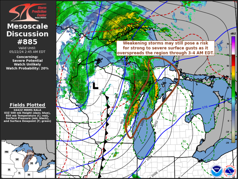
   Mesoscale Discussion 0885
   NWS Storm Prediction Center Norman OK
   1145 PM CDT Tue May 21 2024

   Areas affected...Parts of eastern Wisconsin...northwestern lower
   Michigan and eastern Upper Michigan

   Concerning...Severe potential...Watch unlikely

   Valid 220445Z - 220645Z

   Probability of Watch Issuance...20 percent

   SUMMARY...Thunderstorm activity appears likely to continue
   weakening, but could still pose some risk for strong to severe gusts
   through 3-4 AM EDT.

   DISCUSSION...Although seasonably moist inflow with sizable CAPE is
   probably being maintained into lingering thunderstorm activity
   spreading into and through the upper Great Lakes region, convection
   is likely becoming elevated above cool, stable air over Lake
   Michigan.  At the same time, with continuing slow diurnal cooling, a
   modestly moist boundary-layer over inland portions of lower Michigan
   and eastern upper Michigan remains only weakly unstable at best.

   While evaporative cooling in the sub-cloud layer may contribute to
   the downward transport of 50+ kt flow to the surface, severe weather
   potential appears likely to otherwise continue to diminish through
   the next few hours.  As the supporting mid-level short wave trough
   pivots northward toward the Lake Superior vicinity, it appears the
   weakening leading line of convection could graze northwestern lower
   Michigan coastal areas and overspread eastern upper Michigan, while
   the weakening trailing line overspreads its outflow, near/east of
   the Green Bay vicinity toward the eastern upper peninsula of
   Michigan through 07-08Zz.

   ..Kerr.. 05/22/2024

   ...Please see www.spc.noaa.gov for graphic product...

   ATTN...WFO...APX...GRR...MQT...GRB...MKX...

   LAT...LON   46998523 45938435 44018648 43798722 42788800 43548841
               44618798 45968678 47068662 46998523
|
|
Top/All Mesoscale Discussions/Forecast Products/Home
|
|


 @NWSSPC