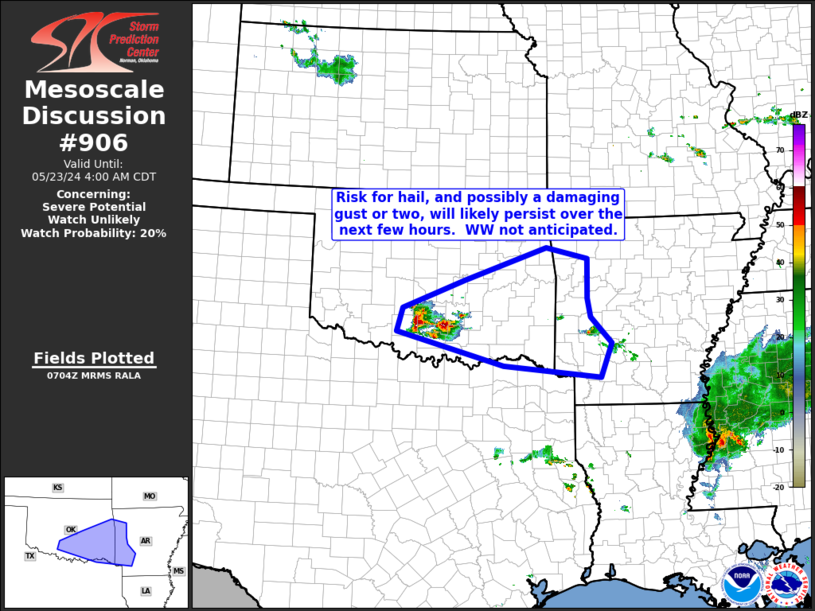
   Mesoscale Discussion 0906
   NWS Storm Prediction Center Norman OK
   0207 AM CDT Thu May 23 2024

   Areas affected...south-central and southeastern Oklahoma...and into
   western Arkansas

   Concerning...Severe potential...Watch unlikely

   Valid 230707Z - 230900Z

   Probability of Watch Issuance...20 percent

   SUMMARY...A few strong/locally severe storms will likely persist
   over the next few hours.  Hail in the 1" to 1.75" range, and
   possibly a strong/damaging gust or two, will be possible with the
   strongest storms.

   DISCUSSION...Latest radar loop shows a gradually expanding cluster
   of storms over south-central Oklahoma.  The storms are not
   well-depicted by any recent CAM runs, but are occurring in tandem
   with a weak cyclonic mid-level circulation evident in water vapor
   imagery, and near the nose of an associated 40 kt southerly
   low-level jet.  The resulting QG forcing, co-located with an axis of
   1500 to 2000 J/kg slightly elevated CAPE, should allow continuance
   of the ongoing storms, and possibly a minor increase in storm
   coverage.

   Latest area VWP data shows weakly veering flow through the
   cloud-bearing layer (roughly 850mb to 150 mb), that increases with
   height -- particularly at mid to upper levels.  The resulting
   effective-layer (LCL to mid-cloud depth) supports potential for
   organized/rotating storms.  With storms slightly elevated atop a
   modestly stable layer, primary risk should remain large hail, though
   a stronger gust or two cannot be ruled out.  Overall, with risk
   expected to remain isolated to a couple of the strongest storms,
   current expectations are that wW issuance should remain unnecessary.

   ..Goss/Edwards.. 05/23/2024

   ...Please see www.spc.noaa.gov for graphic product...

   ATTN...WFO...LZK...SHV...TSA...FWD...OUN...

   LAT...LON   34389803 34829789 35359650 35959465 35749371 35019372
               34669365 34169318 33539344 33759562 34389803
|


 @NWSSPC