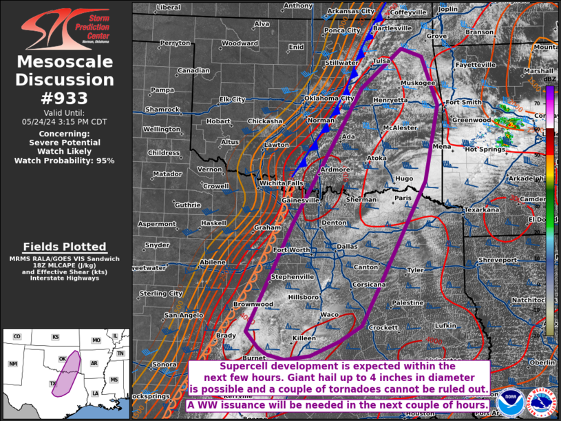
   Mesoscale Discussion 0933
   NWS Storm Prediction Center Norman OK
   0148 PM CDT Fri May 24 2024

   Areas affected...portions of central and northeast Texas...eastern
   Oklahoma

   Concerning...Severe potential...Watch likely

   Valid 241848Z - 242015Z

   Probability of Watch Issuance...95 percent

   SUMMARY...Supercell thunderstorms are expected to develop and
   increase in coverage through the afternoon. Very large hail (some
   stones possibly reaching 4 inches in diameter) and severe gusts are
   the main threats, though a couple of tornadoes could also occur. A
   WW issuance will be needed in the next couple of hours.

   DISCUSSION...Cumulus are gradually deepening ahead of a cold front
   sagging southward across central OK, and a dryline over central TX.
   Ahead of these boundaries, surface temperatures are warming well
   into the 80s F amid mid to upper 70s F dewpoints. 7-8 C/km mid-level
   lapse rates are overspreading this very moist, deep boundary layer,
   contributing to 4000+ J/kg MLCAPE already in place over much of
   eastern OK into northeastern and central TX. MLCAPE may peak to 5000
   J/kg in spots, and when considering elongated hodographs
   (contributing to 50-60 kts of effective bulk shear), splitting
   supercells are expected. These supercells may become quite intense,
   fostering prolonged periods of hail suspension, perhaps allowing
   some stones to grow up to 4 inches in diameter. Severe gusts may
   also occur with the stronger storm cores. Limited directional and
   speed shear in the lowest few km suggests that the overall tornado
   threat may be limited. However, robust right-moving supercells could
   produce tornadoes given the extreme instability, especially if any
   storms manage to traverse meso-gamma scale boundaries. A WW issuance
   will be needed in the next couple of hours to address the impending
   severe threat.

   ..Squitieri/Guyer.. 05/24/2024

   ...Please see www.spc.noaa.gov for graphic product...

   ATTN...WFO...SHV...TSA...FWD...OUN...EWX...SJT...

   LAT...LON   31429623 31149669 30889732 30809787 30899825 31019842
               31319869 33289772 35739623 36459534 36309488 35439454
               34049483 32219580 31429623
|


 @NWSSPC