|
| Mesoscale Discussion 967 |
|
< Previous MD Next MD >
|
|
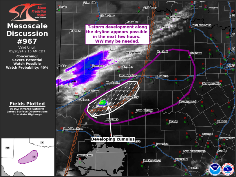
   Mesoscale Discussion 0967
   NWS Storm Prediction Center Norman OK
   1222 AM CDT Sun May 26 2024

   Areas affected...West central Texas

   Concerning...Severe potential...Watch possible

   Valid 260522Z - 260715Z

   Probability of Watch Issuance...40 percent

   SUMMARY...Thunderstorm development along the dryline northwest of
   the San Angelo region appears possible within the next few hours
   based on satellite observations and trends in numerical guidance.
   Given a conditionally favorable severe environment, watch issuance
   may be warranted later tonight.

   DISCUSSION...Over the past 30 minutes, a small cluster of cumulus
   has become evident in GOES IR and nighttime microphysics imagery to
   the northwest of the San Angelo, TX area along the surface dryline.
   Low-level confluence along the boundary appears fairly weak based on
   regional surface observations, and MLCIN continues to increase amid
   nocturnal cooling. However, the steady deepening recently observed
   suggests that some nebulous forcing for ascent may be sufficient for
   a couple attempts at convective initiation. Confidence in
   thunderstorm development is low given the aforementioned concerns,
   but recent HRRR solutions hint that a few storms may emerge during
   the 07-10 UTC time frame across west-central TX. Given a
   conditionally favorable convective environment (MLCAPE between
   2000-2500 J/kg, 0-6 km BWD values near 50 knots among other
   metrics), thunderstorms that can mature may pose a severe risk.
   Trends will continue to be monitored for the need for a watch later
   tonight.

   ..Moore/Edwards.. 05/26/2024

   ...Please see www.spc.noaa.gov for graphic product...

   ATTN...WFO...FWD...SJT...MAF...

   LAT...LON   31300198 31490217 31790191 32400068 32939988 33199957
               33289918 33229863 32789843 32459843 32049862 31709907
               31479968 31400000 31240056 31130106 31100141 31170176
               31300198
|
|
Top/All Mesoscale Discussions/Forecast Products/Home
|
|


 @NWSSPC