|
| Mesoscale Discussion 968 |
|
< Previous MD Next MD >
|

|
   Mesoscale Discussion 0968
   NWS Storm Prediction Center Norman OK
   0103 AM CDT Sun May 26 2024

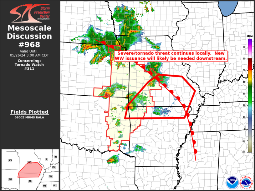
   Areas affected...south-central and southeastern Missouri into
   northern Arkansas

   Concerning...Tornado Watch 311...

   Valid 260603Z - 260800Z

   The severe weather threat for Tornado Watch 311 continues.

   SUMMARY...Storms continue moving eastward across central and
   southern Missouri and now, portions of far northwestern Arkansas --
   within WW 311.  As storms continue eastward, new WW issuance is
   anticipated.

   DISCUSSION...Latest radar loop shows strong/locally severe storms,
   including a pair of supercells (one crossing Polk and Dallas
   Counties in Missouri and the other over Delaware County Oklahoma and
   moving into Benton County Arkansas), moving eastward into/across the
   Ozarks area.  Downstream from these storms, RAP-based objective
   analysis shows a favorably unstable airmass to the southwest of a
   warm front that roughly bisects Missouri from northwest to
   southeast.  Given the available warm-sector airmass, and favorably
   strong/veering flow with height indicated across this region, it
   would appear that severe risk will continue to expand downstream
   from WW 311 over the next 1 to 2 hours, likely warranting new WW
   issuance.

   ..Edwards.. 05/26/2024

   ...Please see www.spc.noaa.gov for graphic product...

   ATTN...WFO...PAH...MEG...LSX...LZK...SGF...TSA...

   LAT...LON   35779483 36539466 37939318 38359242 38229072 37378979
               35829059 35779483
|
|
Top/All Mesoscale Discussions/Forecast Products/Home
|
|


