 Note:
The expiration time in the watch graphic is amended if the watch is
replaced, cancelled or extended.
Note:
Note:
The expiration time in the watch graphic is amended if the watch is
replaced, cancelled or extended.
Note: Click for
Watch Status Reports.
SEL1
URGENT - IMMEDIATE BROADCAST REQUESTED
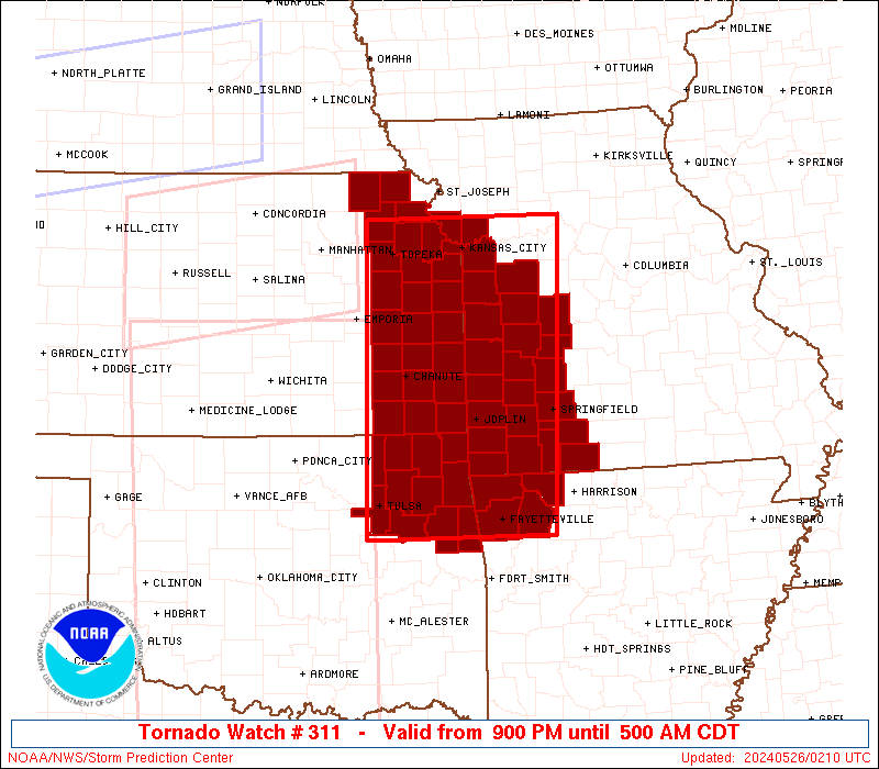
Tornado Watch Number 311
NWS Storm Prediction Center Norman OK
900 PM CDT Sat May 25 2024
The NWS Storm Prediction Center has issued a
* Tornado Watch for portions of
Northwest Arkansas
Eastern Kansas
Western Missouri
Northeast Oklahoma
* Effective this Saturday night and Sunday morning from 900 PM
until 500 AM CDT.
* Primary threats include...
A few tornadoes likely with a couple intense tornadoes possible
Widespread damaging winds and isolated significant gusts to 80
mph likely
Scattered large hail and isolated very large hail events to 2
inches in diameter likely
SUMMARY...Scattered clusters of severe thunderstorms, including
supercells and linear bands, are forecast to move east into the
Watch area this evening and persist into the overnight. The
stronger supercells will potentially be capable of a tornado risk,
in addition to a threat for large hail and severe gusts. Eventual
upscale growth into one or more severe linear bands of storms is
expected and the threat will primarily transition to a risk for
damaging gusts and perhaps a couple of tornadoes.
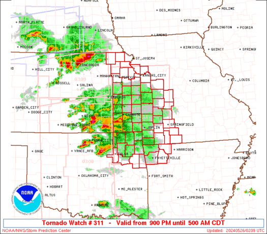
The tornado watch area is approximately along and 75 statute miles
east and west of a line from 20 miles east northeast of Leavenworth
KS to 35 miles west southwest of Fayetteville AR. For a complete
depiction of the watch see the associated watch outline update
(WOUS64 KWNS WOU1).
PRECAUTIONARY/PREPAREDNESS ACTIONS...
REMEMBER...A Tornado Watch means conditions are favorable for
tornadoes and severe thunderstorms in and close to the watch
area. Persons in these areas should be on the lookout for
threatening weather conditions and listen for later statements
and possible warnings.
&&
OTHER WATCH INFORMATION...CONTINUE...WW 307...WW 308...WW
309...WW 310...
AVIATION...Tornadoes and a few severe thunderstorms with hail
surface and aloft to 2 inches. Extreme turbulence and surface wind
gusts to 70 knots. A few cumulonimbi with maximum tops to 500. Mean
storm motion vector 26035.
...Smith
   SEL1

   URGENT - IMMEDIATE BROADCAST REQUESTED
   Tornado Watch Number 311
   NWS Storm Prediction Center Norman OK
   900 PM CDT Sat May 25 2024

   The NWS Storm Prediction Center has issued a

   * Tornado Watch for portions of
     Northwest Arkansas
     Eastern Kansas
     Western Missouri
     Northeast Oklahoma

   * Effective this Saturday night and Sunday morning from 900 PM
     until 500 AM CDT.

   * Primary threats include...
     A few tornadoes likely with a couple intense tornadoes possible
     Widespread damaging winds and isolated significant gusts to 80
       mph likely
     Scattered large hail and isolated very large hail events to 2
       inches in diameter likely

   SUMMARY...Scattered clusters of severe thunderstorms, including
   supercells and linear bands, are forecast to move east into the
   Watch area this evening and persist into the overnight.  The
   stronger supercells will potentially be capable of a tornado risk,
   in addition to a threat for large hail and severe gusts.  Eventual
   upscale growth into one or more severe linear bands of storms is
   expected and the threat will primarily transition to a risk for
   damaging gusts and perhaps a couple of tornadoes.

   The tornado watch area is approximately along and 75 statute miles
   east and west of a line from 20 miles east northeast of Leavenworth
   KS to 35 miles west southwest of Fayetteville AR. For a complete
   depiction of the watch see the associated watch outline update
   (WOUS64 KWNS WOU1).

   PRECAUTIONARY/PREPAREDNESS ACTIONS...

   REMEMBER...A Tornado Watch means conditions are favorable for
   tornadoes and severe thunderstorms in and close to the watch
   area. Persons in these areas should be on the lookout for
   threatening weather conditions and listen for later statements
   and possible warnings.

   &&

   OTHER WATCH INFORMATION...CONTINUE...WW 307...WW 308...WW
   309...WW 310...

   AVIATION...Tornadoes and a few severe thunderstorms with hail
   surface and aloft to 2 inches. Extreme turbulence and surface wind
   gusts to 70 knots. A few cumulonimbi with maximum tops to 500. Mean
   storm motion vector 26035.

   ...Smith
 Note:
The Aviation Watch (SAW) product is an approximation to the watch area.
The actual watch is depicted by the shaded areas.
Note:
The Aviation Watch (SAW) product is an approximation to the watch area.
The actual watch is depicted by the shaded areas.
   SAW1
   WW 311 TORNADO AR KS MO OK 260200Z - 261000Z
   AXIS..75 STATUTE MILES EAST AND WEST OF LINE..
   20ENE FLV/LEAVENWORTH KS/ - 35WSW FYV/FAYETTEVILLE AR/
   ..AVIATION COORDS.. 65NM E/W /13NE MCI - 35NW FSM/
   HAIL SURFACE AND ALOFT..2 INCHES. WIND GUSTS..70 KNOTS.
   MAX TOPS TO 500. MEAN STORM MOTION VECTOR 26035.

   LAT...LON 39469317 35809341 35809609 39469598

   THIS IS AN APPROXIMATION TO THE WATCH AREA.  FOR A
   COMPLETE DEPICTION OF THE WATCH SEE WOUS64 KWNS
   FOR WOU1.
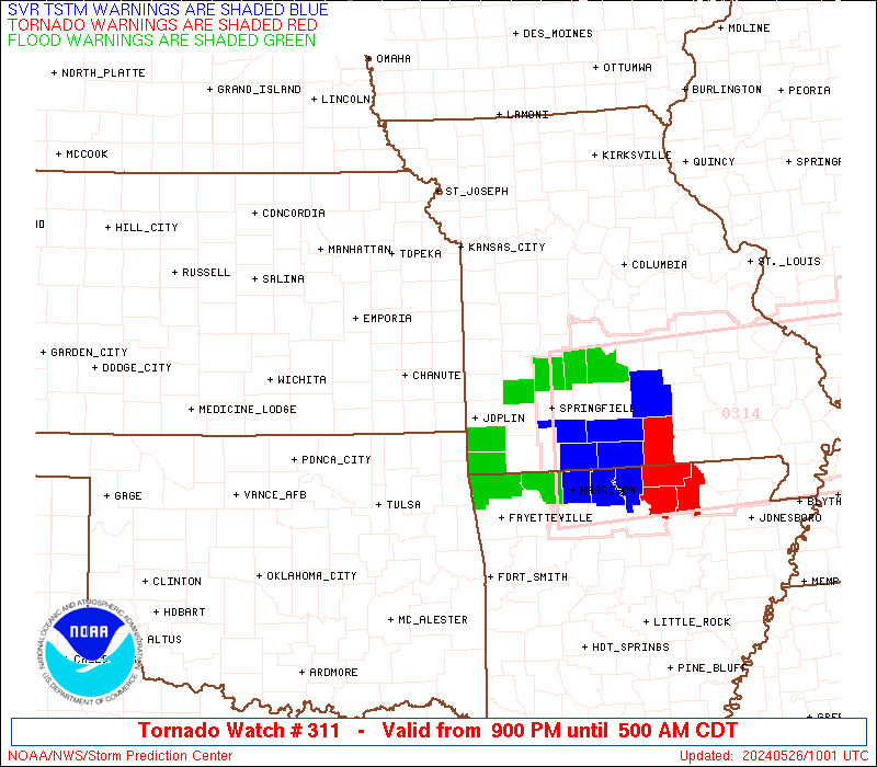
Watch 311 Status Report Messages:
STATUS REPORT #4 ON WW 311

VALID 260850Z - 260940Z

SEVERE WEATHER THREAT CONTINUES RIGHT OF A LINE FROM 30 WSW FYV
TO 5 WSW GMJ TO 40 NE JLN TO 45 N SGF.

..GOSS..05/26/24

ATTN...WFO...TSA...ICT...TOP...EAX...SGF...

&&

STATUS REPORT FOR WT 311

SEVERE WEATHER THREAT CONTINUES FOR THE FOLLOWING AREAS

ARC007-015-087-143-260940-

AR
.    ARKANSAS COUNTIES INCLUDED ARE

BENTON		     CARROLL		 MADISON
WASHINGTON
$$


MOC009-029-043-057-059-077-097-105-109-119-131-141-145-167-209-
213-260940-

MO
.    MISSOURI COUNTIES INCLUDED ARE

BARRY		     CAMDEN		 CHRISTIAN
DADE		     DALLAS		 GREENE
JASPER		     LACLEDE		 LAWRENCE
MCDONALD	     MILLER		 MORGAN
NEWTON		     POLK		 STONE
TANEY
$$


OKC041-260940-

OK
.    OKLAHOMA COUNTIES INCLUDED ARE

DELAWARE
$$


THE WATCH STATUS MESSAGE IS FOR GUIDANCE PURPOSES ONLY.  PLEASE
REFER TO WATCH COUNTY NOTIFICATION STATEMENTS FOR OFFICIAL
INFORMATION ON COUNTIES...INDEPENDENT CITIES AND MARINE ZONES
CLEARED FROM SEVERE THUNDERSTORM AND TORNADO WATCHES.
$$

STATUS REPORT #3 ON WW 311

VALID 260740Z - 260840Z

SEVERE WEATHER THREAT CONTINUES RIGHT OF A LINE FROM 35 N BVO TO
35 SSE CNU TO 50 NNE SGF.

..GOSS..05/26/24

ATTN...WFO...TSA...ICT...TOP...EAX...SGF...

&&

STATUS REPORT FOR WT 311

SEVERE WEATHER THREAT CONTINUES FOR THE FOLLOWING AREAS

ARC007-015-033-047-087-143-260840-

AR
.    ARKANSAS COUNTIES INCLUDED ARE

BENTON		     CARROLL		 CRAWFORD
FRANKLIN	     MADISON		 WASHINGTON
$$


KSC019-021-035-099-125-260840-

KS
.    KANSAS COUNTIES INCLUDED ARE

CHAUTAUQUA	     CHEROKEE		 COWLEY
LABETTE 	     MONTGOMERY
$$


MOC009-011-029-043-057-059-077-097-105-109-119-131-145-167-209-
213-260840-

MO
.    MISSOURI COUNTIES INCLUDED ARE

BARRY		     BARTON		 CAMDEN
CHRISTIAN	     DADE		 DALLAS
GREENE		     JASPER		 LACLEDE
LAWRENCE	     MCDONALD		 MILLER
NEWTON		     POLK		 STONE
TANEY
$$


OKC001-021-035-041-097-101-105-115-131-135-145-147-260840-

OK
.    OKLAHOMA COUNTIES INCLUDED ARE

ADAIR		     CHEROKEE		 CRAIG
DELAWARE	     MAYES		 MUSKOGEE
NOWATA		     OTTAWA		 ROGERS
SEQUOYAH	     WAGONER		 WASHINGTON
$$


THE WATCH STATUS MESSAGE IS FOR GUIDANCE PURPOSES ONLY.  PLEASE
REFER TO WATCH COUNTY NOTIFICATION STATEMENTS FOR OFFICIAL
INFORMATION ON COUNTIES...INDEPENDENT CITIES AND MARINE ZONES
CLEARED FROM SEVERE THUNDERSTORM AND TORNADO WATCHES.
$$

STATUS REPORT #2 ON WW 311

VALID 260705Z - 260840Z

SEVERE WEATHER THREAT CONTINUES RIGHT OF A LINE FROM 35 NNW BVO
TO 30 SSE CNU TO 20 N JLN TO 45 N SGF.

..GOSS..05/26/24

ATTN...WFO...TSA...ICT...TOP...EAX...SGF...

&&

STATUS REPORT FOR WT 311

SEVERE WEATHER THREAT CONTINUES FOR THE FOLLOWING AREAS

ARC007-015-033-047-087-131-143-260840-

AR
.    ARKANSAS COUNTIES INCLUDED ARE

BENTON		     CARROLL		 CRAWFORD
FRANKLIN	     MADISON		 SEBASTIAN
WASHINGTON
$$


KSC021-099-125-260840-

KS
.    KANSAS COUNTIES INCLUDED ARE

CHEROKEE	     LABETTE		 MONTGOMERY
$$


MOC009-011-043-057-059-077-097-105-109-119-145-167-209-213-
260840-

MO
.    MISSOURI COUNTIES INCLUDED ARE

BARRY		     BARTON		 CHRISTIAN
DADE		     DALLAS		 GREENE
JASPER		     LACLEDE		 LAWRENCE
MCDONALD	     NEWTON		 POLK
STONE		     TANEY
$$


OKC001-021-023-035-041-061-077-079-091-097-101-105-111-115-121-
127-131-135-143-145-147-260840-

OK
.    OKLAHOMA COUNTIES INCLUDED ARE

ADAIR		     CHEROKEE		 CHOCTAW
CRAIG		     DELAWARE		 HASKELL
LATIMER 	     LE FLORE		 MCINTOSH
MAYES		     MUSKOGEE		 NOWATA
OKMULGEE	     OTTAWA		 PITTSBURG
PUSHMATAHA	     ROGERS		 SEQUOYAH
TULSA		     WAGONER		 WASHINGTON
$$


THE WATCH STATUS MESSAGE IS FOR GUIDANCE PURPOSES ONLY.  PLEASE
REFER TO WATCH COUNTY NOTIFICATION STATEMENTS FOR OFFICIAL
INFORMATION ON COUNTIES...INDEPENDENT CITIES AND MARINE ZONES
CLEARED FROM SEVERE THUNDERSTORM AND TORNADO WATCHES.
$$

STATUS REPORT #1 ON WW 311

VALID 260440Z - 260540Z

THE SEVERE WEATHER THREAT CONTINUES ACROSS THE ENTIRE WATCH AREA.

..MOSIER..05/26/24

ATTN...WFO...TSA...ICT...TOP...EAX...SGF...

&&

STATUS REPORT FOR WT 311

SEVERE WEATHER THREAT CONTINUES FOR THE FOLLOWING AREAS

ARC007-015-087-143-260540-

AR
.    ARKANSAS COUNTIES INCLUDED ARE

BENTON		     CARROLL		 MADISON
WASHINGTON
$$


KSC001-003-005-011-013-021-031-037-045-059-085-087-091-099-103-
107-121-125-131-133-139-177-205-207-209-260540-

KS
.    KANSAS COUNTIES INCLUDED ARE

ALLEN		     ANDERSON		 ATCHISON
BOURBON 	     BROWN		 CHEROKEE
COFFEY		     CRAWFORD		 DOUGLAS
FRANKLIN	     JACKSON		 JEFFERSON
JOHNSON 	     LABETTE		 LEAVENWORTH
LINN		     MIAMI		 MONTGOMERY
NEMAHA		     NEOSHO		 OSAGE
SHAWNEE 	     WILSON		 WOODSON
WYANDOTTE
$$


MOC009-011-013-015-037-039-043-047-057-077-083-085-095-097-101-
109-119-145-165-167-185-209-213-217-260540-

MO
.    MISSOURI COUNTIES INCLUDED ARE

BARRY		     BARTON		 BATES
BENTON		     CASS		 CEDAR
CHRISTIAN	     CLAY		 DADE
GREENE		     HENRY		 HICKORY
JACKSON 	     JASPER		 JOHNSON
LAWRENCE	     MCDONALD		 NEWTON
PLATTE		     POLK		 ST. CLAIR
STONE		     TANEY		 VERNON
$$


OKC001-021-035-041-097-105-115-131-143-145-147-260540-

OK
.    OKLAHOMA COUNTIES INCLUDED ARE

ADAIR		     CHEROKEE		 CRAIG
DELAWARE	     MAYES		 NOWATA
OTTAWA		     ROGERS		 TULSA
WAGONER 	     WASHINGTON
$$


THE WATCH STATUS MESSAGE IS FOR GUIDANCE PURPOSES ONLY.  PLEASE
REFER TO WATCH COUNTY NOTIFICATION STATEMENTS FOR OFFICIAL
INFORMATION ON COUNTIES...INDEPENDENT CITIES AND MARINE ZONES
CLEARED FROM SEVERE THUNDERSTORM AND TORNADO WATCHES.
$$
Note:
Click for Complete Product Text.
Tornadoes
Probability of 2 or more tornadoes
|
Mod (60%)
|
Probability of 1 or more strong (EF2-EF5) tornadoes
|
Mod (40%)
|
Wind
Probability of 10 or more severe wind events
|
High (90%)
|
Probability of 1 or more wind events > 65 knots
|
High (70%)
|
Hail
Probability of 10 or more severe hail events
|
Mod (60%)
|
Probability of 1 or more hailstones > 2 inches
|
Mod (60%)
|
Combined Severe Hail/Wind
Probability of 6 or more combined severe hail/wind events
|
High (>95%)
|
For each watch, probabilities for particular events inside the watch
(listed above in each table) are determined by the issuing forecaster.
The "Low" category contains probability values ranging from less than 2%
to 20% (EF2-EF5 tornadoes), less than 5% to 20% (all other probabilities),
"Moderate" from 30% to 60%, and "High" from 70% to greater than 95%.
High values are bolded and lighter in color to provide awareness of
an increased threat for a particular event.


 @NWSSPC