Note:
The expiration time in the watch graphic is amended if the watch is
replaced, cancelled or extended.
Note:
Note:
The expiration time in the watch graphic is amended if the watch is
replaced, cancelled or extended.
Note: Click for
Watch Status Reports.
SEL8
URGENT - IMMEDIATE BROADCAST REQUESTED
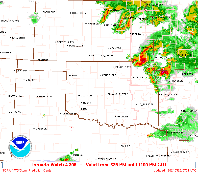
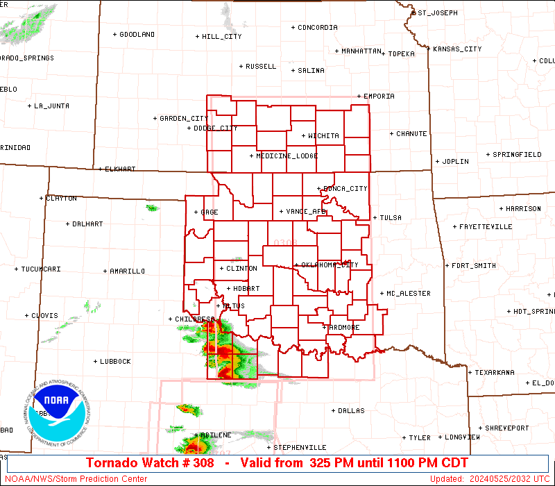
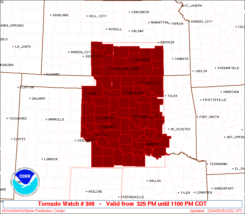
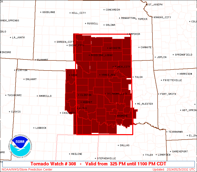
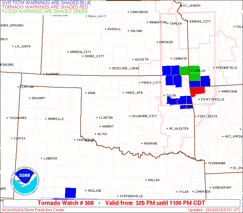
Tornado Watch Number 308
NWS Storm Prediction Center Norman OK
325 PM CDT Sat May 25 2024
The NWS Storm Prediction Center has issued a
* Tornado Watch for portions of
Southcentral Kansas
Western and Central Oklahoma
Extreme Northcentral Texas
* Effective this Saturday afternoon and evening from 325 PM until
1100 PM CDT.
...THIS IS A PARTICULARLY DANGEROUS SITUATION...
* Primary threats include...
Several tornadoes and a few intense tornadoes likely
Widespread large hail and scattered very large hail events to 5
inches in diameter likely
Scattered damaging winds and isolated significant gusts to 80
mph likely
SUMMARY...Intense supercell thunderstorm development is expected to
continue through this evening, with storms moving generally east
across the watch area. The risk for strong, long-track tornadoes
will exist, in addition to giant hail, possibly up to 5 inches in
diameter. Damaging thunderstorm wind gusts in excess of 75 mph can
also be expected.
The tornado watch area is approximately along and 95 statute miles
east and west of a line from 20 miles north northeast of Hutchinson
KS to 60 miles west southwest of Sherman TX. For a complete
depiction of the watch see the associated watch outline update
(WOUS64 KWNS WOU8).
PRECAUTIONARY/PREPAREDNESS ACTIONS...
REMEMBER...A Tornado Watch means conditions are favorable for
tornadoes and severe thunderstorms in and close to the watch
area. Persons in these areas should be on the lookout for
threatening weather conditions and listen for later statements
and possible warnings.
&&
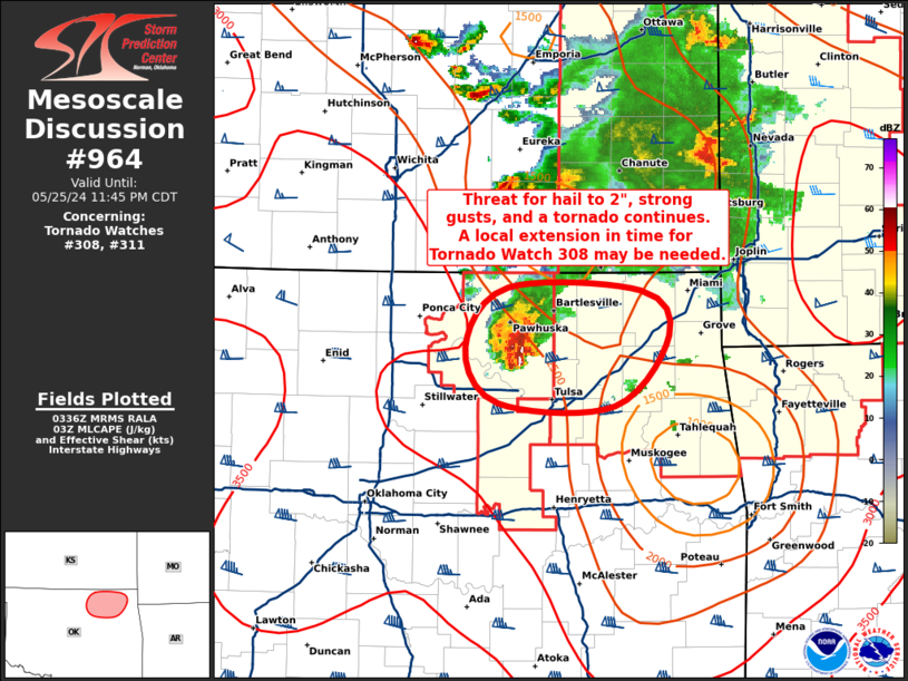
OTHER WATCH INFORMATION...CONTINUE...WW 306...WW 307...
AVIATION...Tornadoes and a few severe thunderstorms with hail
surface and aloft to 5 inches. Extreme turbulence and surface wind
gusts to 70 knots. A few cumulonimbi with maximum tops to 650. Mean
storm motion vector 27030.
...Bunting

   SEL8

   URGENT - IMMEDIATE BROADCAST REQUESTED
   Tornado Watch Number 308
   NWS Storm Prediction Center Norman OK
   325 PM CDT Sat May 25 2024

   The NWS Storm Prediction Center has issued a

   * Tornado Watch for portions of
     Southcentral Kansas
     Western and Central Oklahoma
     Extreme Northcentral Texas

   * Effective this Saturday afternoon and evening from 325 PM until
     1100 PM CDT.

   ...THIS IS A PARTICULARLY DANGEROUS SITUATION...

   * Primary threats include...
     Several tornadoes and a few intense tornadoes likely
     Widespread large hail and scattered very large hail events to 5
       inches in diameter likely
     Scattered damaging winds and isolated significant gusts to 80
       mph likely

   SUMMARY...Intense supercell thunderstorm development is expected to
   continue through this evening, with storms moving generally east
   across the watch area.  The risk for strong, long-track tornadoes
   will exist, in addition to giant hail, possibly up to 5 inches in
   diameter. Damaging thunderstorm wind gusts in excess of 75 mph can
   also be expected.

   The tornado watch area is approximately along and 95 statute miles
   east and west of a line from 20 miles north northeast of Hutchinson
   KS to 60 miles west southwest of Sherman TX. For a complete
   depiction of the watch see the associated watch outline update
   (WOUS64 KWNS WOU8).

   PRECAUTIONARY/PREPAREDNESS ACTIONS...

   REMEMBER...A Tornado Watch means conditions are favorable for
   tornadoes and severe thunderstorms in and close to the watch
   area. Persons in these areas should be on the lookout for
   threatening weather conditions and listen for later statements
   and possible warnings.

   &&

   OTHER WATCH INFORMATION...CONTINUE...WW 306...WW 307...

   AVIATION...Tornadoes and a few severe thunderstorms with hail
   surface and aloft to 5 inches. Extreme turbulence and surface wind
   gusts to 70 knots. A few cumulonimbi with maximum tops to 650. Mean
   storm motion vector 27030.

   ...Bunting
 Note:
The Aviation Watch (SAW) product is an approximation to the watch area.
The actual watch is depicted by the shaded areas.
Note:
The Aviation Watch (SAW) product is an approximation to the watch area.
The actual watch is depicted by the shaded areas.
   SAW8
   WW 308 TORNADO KS OK TX 252025Z - 260400Z
   AXIS..95 STATUTE MILES EAST AND WEST OF LINE..
   20NNE HUT/HUTCHINSON KS/ - 60WSW GYI/SHERMAN TX/
   ..AVIATION COORDS.. 80NM E/W /36S SLN - 43NW TTT/
   HAIL SURFACE AND ALOFT..5 INCHES. WIND GUSTS..70 KNOTS.
   MAX TOPS TO 650. MEAN STORM MOTION VECTOR 27030.

   LAT...LON 38329598 33379598 33379928 38329948

   THIS IS AN APPROXIMATION TO THE WATCH AREA.  FOR A
   COMPLETE DEPICTION OF THE WATCH SEE WOUS64 KWNS
   FOR WOU8.
Watch 308 Status Report Messages:
STATUS REPORT #3 ON WW 308

VALID 260225Z - 260340Z

SEVERE WEATHER THREAT CONTINUES RIGHT OF A LINE FROM 40 SSE SPS
TO 40 WNW ADM TO 40 SSW ICT TO 35 NW HUT.

..MOSIER..05/26/24

ATTN...WFO...DDC...ICT...OUN...TSA...FWD...

&&

STATUS REPORT FOR WT 308

SEVERE WEATHER THREAT CONTINUES FOR THE FOLLOWING AREAS

KSC015-019-035-049-073-079-155-173-191-260340-

KS
.    KANSAS COUNTIES INCLUDED ARE

BUTLER		     CHAUTAUQUA 	 COWLEY
ELK		     GREENWOOD		 HARVEY
RENO		     SEDGWICK		 SUMNER
$$


OKC005-013-019-027-029-037-049-063-067-069-071-081-083-085-087-
095-099-103-107-109-113-117-119-123-125-133-260340-

OK
.    OKLAHOMA COUNTIES INCLUDED ARE

ATOKA		     BRYAN		 CARTER
CLEVELAND	     COAL		 CREEK
GARVIN		     HUGHES		 JEFFERSON
JOHNSTON	     KAY		 LINCOLN
LOGAN		     LOVE		 MCCLAIN
MARSHALL	     MURRAY		 NOBLE
OKFUSKEE	     OKLAHOMA		 OSAGE
PAWNEE		     PAYNE		 PONTOTOC
POTTAWATOMIE	     SEMINOLE
$$


TXC097-337-260340-

TX
.    TEXAS COUNTIES INCLUDED ARE

COOKE		     MONTAGUE
$$


THE WATCH STATUS MESSAGE IS FOR GUIDANCE PURPOSES ONLY.  PLEASE
REFER TO WATCH COUNTY NOTIFICATION STATEMENTS FOR OFFICIAL
INFORMATION ON COUNTIES...INDEPENDENT CITIES AND MARINE ZONES
CLEARED FROM SEVERE THUNDERSTORM AND TORNADO WATCHES.
$$

STATUS REPORT #2 ON WW 308

VALID 260050Z - 260140Z

SEVERE WEATHER THREAT CONTINUES RIGHT OF A LINE FROM 70 WSW AVK
TO 30 WNW AVK TO 30 NW P28 TO 30 SSW RSL.

..LYONS..05/26/24

ATTN...WFO...DDC...ICT...OUN...TSA...FWD...

&&

STATUS REPORT FOR WT 308

SEVERE WEATHER THREAT CONTINUES FOR THE FOLLOWING AREAS

KSC007-015-019-035-049-073-077-079-095-151-155-173-185-191-
260140-

KS
.    KANSAS COUNTIES INCLUDED ARE

BARBER		     BUTLER		 CHAUTAUQUA
COWLEY		     ELK		 GREENWOOD
HARPER		     HARVEY		 KINGMAN
PRATT		     RENO		 SEDGWICK
STAFFORD	     SUMNER
$$


OKC003-005-009-011-013-015-017-019-027-029-031-033-037-039-043-
045-047-049-051-053-055-057-063-065-067-069-071-073-075-081-083-
085-087-093-095-099-103-107-109-113-117-119-123-125-129-133-137-
141-149-151-153-260140-

OK
.    OKLAHOMA COUNTIES INCLUDED ARE

ALFALFA 	     ATOKA		 BECKHAM
BLAINE		     BRYAN		 CADDO
CANADIAN	     CARTER		 CLEVELAND
COAL		     COMANCHE		 COTTON
CREEK		     CUSTER		 DEWEY
ELLIS		     GARFIELD		 GARVIN
GRADY		     GRANT		 GREER
HARMON		     HUGHES		 JACKSON
JEFFERSON	     JOHNSTON		 KAY
KINGFISHER	     KIOWA		 LINCOLN
LOGAN		     LOVE		 MCCLAIN
MAJOR		     MARSHALL		 MURRAY
NOBLE		     OKFUSKEE		 OKLAHOMA
OSAGE		     PAWNEE		 PAYNE
PONTOTOC	     POTTAWATOMIE	 ROGER MILLS
SEMINOLE	     STEPHENS		 TILLMAN
WASHITA 	     WOODS		 WOODWARD
$$


TXC009-023-077-097-337-485-487-260140-

TX
.    TEXAS COUNTIES INCLUDED ARE

ARCHER		     BAYLOR		 CLAY
COOKE		     MONTAGUE		 WICHITA
WILBARGER
$$


THE WATCH STATUS MESSAGE IS FOR GUIDANCE PURPOSES ONLY.  PLEASE
REFER TO WATCH COUNTY NOTIFICATION STATEMENTS FOR OFFICIAL
INFORMATION ON COUNTIES...INDEPENDENT CITIES AND MARINE ZONES
CLEARED FROM SEVERE THUNDERSTORM AND TORNADO WATCHES.
$$

STATUS REPORT #1 ON WW 308

VALID 252115Z - 252240Z

THE SEVERE WEATHER THREAT CONTINUES ACROSS THE ENTIRE WATCH AREA.

..LYONS..05/25/24

ATTN...WFO...DDC...ICT...OUN...TSA...FWD...

&&

STATUS REPORT FOR WT 308

SEVERE WEATHER THREAT CONTINUES FOR THE FOLLOWING AREAS

KSC007-015-019-033-035-047-049-073-077-079-095-097-145-151-155-
173-185-191-252240-

KS
.    KANSAS COUNTIES INCLUDED ARE

BARBER		     BUTLER		 CHAUTAUQUA
COMANCHE	     COWLEY		 EDWARDS
ELK		     GREENWOOD		 HARPER
HARVEY		     KINGMAN		 KIOWA
PAWNEE		     PRATT		 RENO
SEDGWICK	     STAFFORD		 SUMNER
$$


OKC003-005-009-011-013-015-017-019-027-029-031-033-037-039-043-
045-047-049-051-053-055-057-063-065-067-069-071-073-075-081-083-
085-087-093-095-099-103-107-109-113-117-119-123-125-129-133-137-
141-149-151-153-252240-

OK
.    OKLAHOMA COUNTIES INCLUDED ARE

ALFALFA 	     ATOKA		 BECKHAM
BLAINE		     BRYAN		 CADDO
CANADIAN	     CARTER		 CLEVELAND
COAL		     COMANCHE		 COTTON
CREEK		     CUSTER		 DEWEY
ELLIS		     GARFIELD		 GARVIN
GRADY		     GRANT		 GREER
HARMON		     HUGHES		 JACKSON
JEFFERSON	     JOHNSTON		 KAY
KINGFISHER	     KIOWA		 LINCOLN
LOGAN		     LOVE		 MCCLAIN
MAJOR		     MARSHALL		 MURRAY
NOBLE		     OKFUSKEE		 OKLAHOMA
OSAGE		     PAWNEE		 PAYNE
PONTOTOC	     POTTAWATOMIE	 ROGER MILLS
SEMINOLE	     STEPHENS		 TILLMAN
WASHITA 	     WOODS		 WOODWARD
$$


TXC009-023-077-097-337-485-487-252240-

TX
.    TEXAS COUNTIES INCLUDED ARE

ARCHER		     BAYLOR		 CLAY
COOKE		     MONTAGUE		 WICHITA
WILBARGER
$$


THE WATCH STATUS MESSAGE IS FOR GUIDANCE PURPOSES ONLY.  PLEASE
REFER TO WATCH COUNTY NOTIFICATION STATEMENTS FOR OFFICIAL
INFORMATION ON COUNTIES...INDEPENDENT CITIES AND MARINE ZONES
CLEARED FROM SEVERE THUNDERSTORM AND TORNADO WATCHES.
$$
Note:
Click for Complete Product Text.
Tornadoes
Probability of 2 or more tornadoes
|
High (90%)
|
Probability of 1 or more strong (EF2-EF5) tornadoes
|
High (80%)
|
Wind
Probability of 10 or more severe wind events
|
Mod (60%)
|
Probability of 1 or more wind events > 65 knots
|
Mod (60%)
|
Hail
Probability of 10 or more severe hail events
|
High (80%)
|
Probability of 1 or more hailstones > 2 inches
|
High (80%)
|
Combined Severe Hail/Wind
Probability of 6 or more combined severe hail/wind events
|
High (>95%)
|
For each watch, probabilities for particular events inside the watch
(listed above in each table) are determined by the issuing forecaster.
The "Low" category contains probability values ranging from less than 2%
to 20% (EF2-EF5 tornadoes), less than 5% to 20% (all other probabilities),
"Moderate" from 30% to 60%, and "High" from 70% to greater than 95%.
High values are bolded and lighter in color to provide awareness of
an increased threat for a particular event.


 @NWSSPC