|
| Mesoscale Discussion 970 |
|
< Previous MD Next MD >
|
|
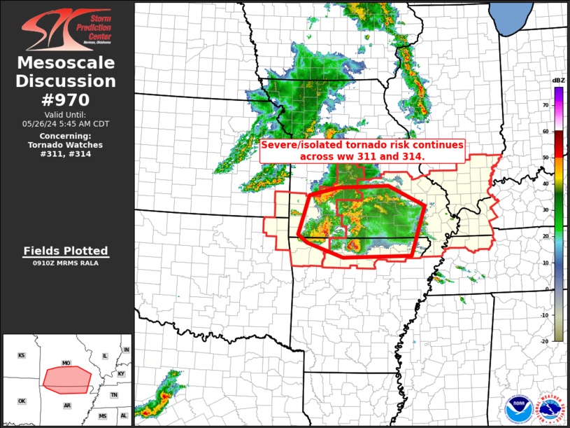
   Mesoscale Discussion 0970
   NWS Storm Prediction Center Norman OK
   0412 AM CDT Sun May 26 2024

   Areas affected...southern Missouri and northern Arkansas

   Concerning...Tornado Watch 311...314...

   Valid 260912Z - 261045Z

   The severe weather threat for Tornado Watch 311, 314 continues.

   SUMMARY...Severe/tornado risk continues across southern Missouri and
   northern Arkansas.

   DISCUSSION...Latest radar loop shows complex clustering of
   severe/supercell storms, including spin-up of several small
   low-level circulations -- and associated/brief tornadoes -- in the
   past half hour over southern Missouri.  Meanwhile, the two more
   substantial/long-lived supercells -- one now moving
   east-southeastward across Stone County Missouri and the other
   crossing Marion County Arkansas -- both remain capable of producing
   all-hazards severe weather.  The Marion County storm, in particular,
   appears to have produced a tornado over the past 15 minutes per
   WSR-88D correlation coefficient.

   Severe potential will likely continue/spread eastward over the next
   few hours.  Gradually, storms will vacate eastern portions of
   Tornado Watch 311, and move fully into Tornado Watch 314.  However,
   storms may not fully clear WW 311 prior to its scheduled 10Z
   expiration -- possibly requiring an EXT to cover the ongoing risk.

   ..Goss.. 05/26/2024

   ...Please see www.spc.noaa.gov for graphic product...

   ATTN...WFO...PAH...MEG...LSX...LZK...SGF...TSA...

   LAT...LON   35999286 36369401 36589430 37609396 37799303 37849139
               37329021 36039066 35999286
|
|
Top/All Mesoscale Discussions/Forecast Products/Home
|
|


 @NWSSPC