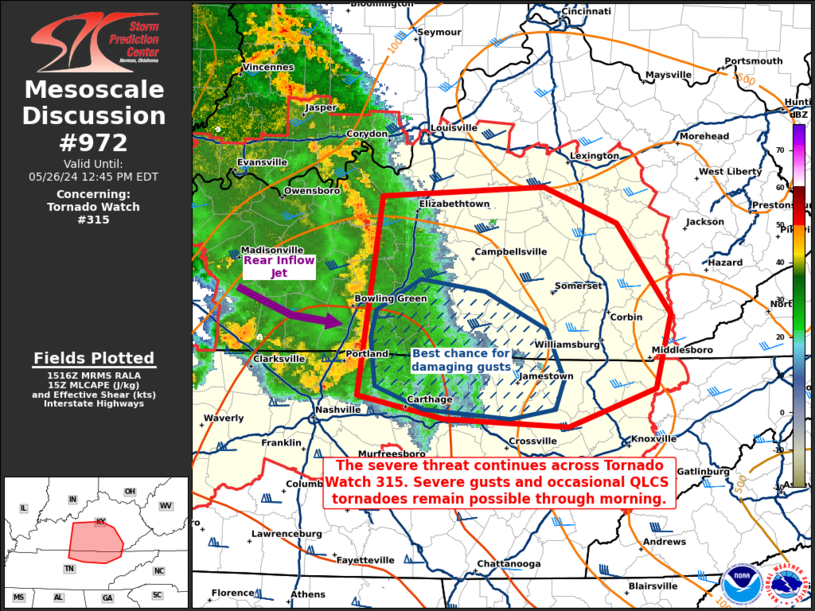
   Mesoscale Discussion 0972
   NWS Storm Prediction Center Norman OK
   1017 AM CDT Sun May 26 2024

   Areas affected...portions of central Kentucky into northern
   Tennessee

   Concerning...Tornado Watch 315...

   Valid 261517Z - 261645Z

   The severe weather threat for Tornado Watch 315 continues.

   SUMMARY...The severe threat continues across Tornado Watch 315. A
   bow echo will continue to progress eastward with a damaging wind
   threat, and a few more QLCS tornadoes remain possible.

   DISCUSSION...A well organized bow echo MCS, with a history of severe
   wind gusts, wind damage, and occasional QLCS tornadoes, continues to
   rapidly track eastward across portions of the TN Valley. At the
   moment, the bow appears slightly less robust compared to earlier
   stages, perhaps due to gradually waning instability with eastward
   extent. Nonetheless, the Kentucky mesonet continues to show
   widespread 45-55 mph wind gusts occurring with the bow, with
   regional radars also depicting occasional, brief QLCS circulations
   developing. With adequate vertical wind shear, over 2000 J/kg MLCAPE
   and weakening MLCINH (given diurnal heating) preceding the bow,
   damaging gusts (perhaps exceeding severe limits at times) should
   continue across much of the rest of KY and northern TN. A couple of
   additional QLCS tornado also cannot be ruled out.

   ..Squitieri.. 05/26/2024

   ...Please see www.spc.noaa.gov for graphic product...

   ATTN...WFO...MRX...JKL...LMK...OHX...

   LAT...LON   37798616 37878467 37608401 36938351 36378365 36098446
               36168560 36338639 37798616
|


 @NWSSPC