Note:
The expiration time in the watch graphic is amended if the watch is
replaced, cancelled or extended.
Note:
Note:
The expiration time in the watch graphic is amended if the watch is
replaced, cancelled or extended.
Note: Click for
Watch Status Reports.
SEL5
URGENT - IMMEDIATE BROADCAST REQUESTED
Tornado Watch Number 315
NWS Storm Prediction Center Norman OK
855 AM CDT Sun May 26 2024
The NWS Storm Prediction Center has issued a
* Tornado Watch for portions of
Southern Indiana
Western and Central Kentucky
Western and Middle Tennessee
* Effective this Sunday morning and afternoon from 855 AM until
300 PM CDT.
* Primary threats include...
A few tornadoes likely with a couple intense tornadoes possible
Widespread damaging winds and isolated significant gusts to 75
mph likely
Scattered large hail and isolated very large hail events to 2
inches in diameter likely
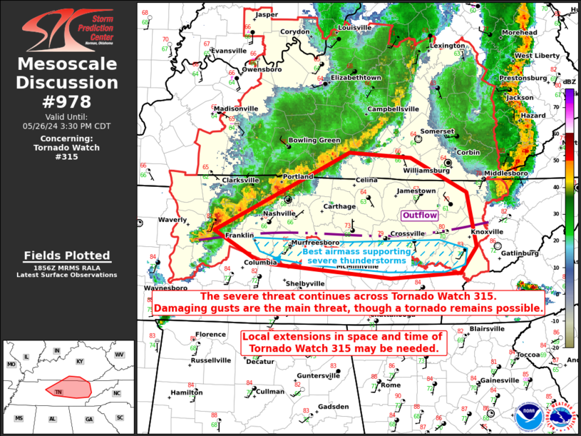
SUMMARY...A bowing complex of severe thunderstorms will continue
moving rapidly east, with widespread damaging winds likely. Some
gusts may exceed 75 mph. A few tornadoes are also possible.
The tornado watch area is approximately along and 80 statute miles
north and south of a line from 10 miles northwest of Fort Campbell
KY to 40 miles south southeast of London KY. For a complete
depiction of the watch see the associated watch outline update
(WOUS64 KWNS WOU5).
PRECAUTIONARY/PREPAREDNESS ACTIONS...
REMEMBER...A Tornado Watch means conditions are favorable for
tornadoes and severe thunderstorms in and close to the watch
area. Persons in these areas should be on the lookout for
threatening weather conditions and listen for later statements
and possible warnings.
&&
OTHER WATCH INFORMATION...CONTINUE...WW 314...
AVIATION...Tornadoes and a few severe thunderstorms with hail
surface and aloft to 2 inches. Extreme turbulence and surface wind
gusts to 65 knots. A few cumulonimbi with maximum tops to 500. Mean
storm motion vector 27045.
...Bunting

   SEL5

   URGENT - IMMEDIATE BROADCAST REQUESTED
   Tornado Watch Number 315
   NWS Storm Prediction Center Norman OK
   855 AM CDT Sun May 26 2024

   The NWS Storm Prediction Center has issued a

   * Tornado Watch for portions of
     Southern Indiana
     Western and Central Kentucky
     Western and Middle Tennessee

   * Effective this Sunday morning and afternoon from 855 AM until
     300 PM CDT.

   * Primary threats include...
     A few tornadoes likely with a couple intense tornadoes possible
     Widespread damaging winds and isolated significant gusts to 75
       mph likely
     Scattered large hail and isolated very large hail events to 2
       inches in diameter likely

   SUMMARY...A bowing complex of severe thunderstorms will continue
   moving rapidly east, with widespread damaging winds likely.  Some
   gusts may exceed 75 mph. A few tornadoes are also possible.

   The tornado watch area is approximately along and 80 statute miles
   north and south of a line from 10 miles northwest of Fort Campbell
   KY to 40 miles south southeast of London KY. For a complete
   depiction of the watch see the associated watch outline update
   (WOUS64 KWNS WOU5).

   PRECAUTIONARY/PREPAREDNESS ACTIONS...

   REMEMBER...A Tornado Watch means conditions are favorable for
   tornadoes and severe thunderstorms in and close to the watch
   area. Persons in these areas should be on the lookout for
   threatening weather conditions and listen for later statements
   and possible warnings.

   &&

   OTHER WATCH INFORMATION...CONTINUE...WW 314...

   AVIATION...Tornadoes and a few severe thunderstorms with hail
   surface and aloft to 2 inches. Extreme turbulence and surface wind
   gusts to 65 knots. A few cumulonimbi with maximum tops to 500. Mean
   storm motion vector 27045.

   ...Bunting
 Note:
The Aviation Watch (SAW) product is an approximation to the watch area.
The actual watch is depicted by the shaded areas.
Note:
The Aviation Watch (SAW) product is an approximation to the watch area.
The actual watch is depicted by the shaded areas.
   SAW5
   WW 315 TORNADO IN KY TN 261355Z - 262000Z
   AXIS..80 STATUTE MILES NORTH AND SOUTH OF LINE..
   10NW HOP/FORT CAMPBELL KY/ - 40SSE LOZ/LONDON KY/
   ..AVIATION COORDS.. 70NM N/S /57W BWG - 33SSE LOZ/
   HAIL SURFACE AND ALOFT..2 INCHES. WIND GUSTS..65 KNOTS.
   MAX TOPS TO 500. MEAN STORM MOTION VECTOR 27045.

   LAT...LON 37938761 37708380 35398380 35618761

   THIS IS AN APPROXIMATION TO THE WATCH AREA.  FOR A
   COMPLETE DEPICTION OF THE WATCH SEE WOUS64 KWNS
   FOR WOU5.
Watch 315 Status Report Messages:
STATUS REPORT #2 ON WW 315

VALID 261835Z - 261940Z

SEVERE WEATHER THREAT CONTINUES RIGHT OF A LINE FROM 25 SW HOP TO
10 ENE CKV TO 15 NE BWG TO 45 SSE SDF TO 30 NE SDF.

FOR ADDITIONAL INFORMATION SEE MESOSCALE DISCUSSION 0

..LYONS..05/26/24

ATTN...WFO...LMK...PAH...JKL...MRX...OHX...

&&

STATUS REPORT FOR WT 315

SEVERE WEATHER THREAT CONTINUES FOR THE FOLLOWING AREAS

KYC001-003-005-009-013-021-045-049-051-053-057-065-067-079-087-
109-113-121-125-129-137-141-147-151-155-167-169-171-173-179-189-
197-199-203-207-211-213-215-217-219-227-229-231-235-239-
261940-

KY
.    KENTUCKY COUNTIES INCLUDED ARE

ADAIR		     ALLEN		 ANDERSON
BARREN		     BELL		 BOYLE
CASEY		     CLARK		 CLAY
CLINTON 	     CUMBERLAND 	 ESTILL
FAYETTE 	     GARRARD		 GREEN
JACKSON 	     JESSAMINE		 KNOX
LAUREL		     LEE		 LINCOLN
LOGAN		     MCCREARY		 MADISON
MARION		     MERCER		 METCALFE
MONROE		     MONTGOMERY 	 NELSON
OWSLEY		     POWELL		 PULASKI
ROCKCASTLE	     RUSSELL		 SHELBY
SIMPSON 	     SPENCER		 TAYLOR
TODD		     WARREN		 WASHINGTON
WAYNE		     WHITLEY		 WOODFORD
$$


TNC001-009-013-021-025-027-035-037-041-043-049-081-083-085-087-
093-105-111-125-129-133-135-137-141-145-147-149-151-159-165-169-
173-185-187-189-261940-

TN
.    TENNESSEE COUNTIES INCLUDED ARE

ANDERSON	     BLOUNT		 CAMPBELL
CHEATHAM	     CLAIBORNE		 CLAY
CUMBERLAND	     DAVIDSON		 DE KALB
DICKSON 	     FENTRESS		 HICKMAN
HOUSTON 	     HUMPHREYS		 JACKSON
KNOX		     LOUDON		 MACON
MONTGOMERY	     MORGAN		 OVERTON
PERRY		     PICKETT		 PUTNAM
ROANE		     ROBERTSON		 RUTHERFORD
SCOTT		     SMITH		 SUMNER
TROUSDALE	     UNION		 WHITE
WILLIAMSON	     WILSON
$$


THE WATCH STATUS MESSAGE IS FOR GUIDANCE PURPOSES ONLY.  PLEASE
REFER TO WATCH COUNTY NOTIFICATION STATEMENTS FOR OFFICIAL
INFORMATION ON COUNTIES...INDEPENDENT CITIES AND MARINE ZONES
CLEARED FROM SEVERE THUNDERSTORM AND TORNADO WATCHES.
$$

STATUS REPORT #1 ON WW 315

VALID 261615Z - 261740Z

SEVERE WEATHER THREAT CONTINUES RIGHT OF A LINE FROM 40 SW OWB TO
35 ENE BWG TO 20 SE SDF.

..SQUITIERI..05/26/24

ATTN...WFO...LMK...PAH...JKL...MRX...OHX...

&&

STATUS REPORT FOR WT 315

SEVERE WEATHER THREAT CONTINUES FOR THE FOLLOWING AREAS

KYC001-003-005-009-013-021-029-045-047-049-051-053-057-065-067-
079-087-109-111-113-121-125-129-137-141-147-151-155-167-169-171-
173-179-189-197-199-203-207-211-213-215-217-219-227-229-231-235-
239-261740-

KY
.    KENTUCKY COUNTIES INCLUDED ARE

ADAIR		     ALLEN		 ANDERSON
BARREN		     BELL		 BOYLE
BULLITT 	     CASEY		 CHRISTIAN
CLARK		     CLAY		 CLINTON
CUMBERLAND	     ESTILL		 FAYETTE
GARRARD 	     GREEN		 JACKSON
JEFFERSON	     JESSAMINE		 KNOX
LAUREL		     LEE		 LINCOLN
LOGAN		     MCCREARY		 MADISON
MARION		     MERCER		 METCALFE
MONROE		     MONTGOMERY 	 NELSON
OWSLEY		     POWELL		 PULASKI
ROCKCASTLE	     RUSSELL		 SHELBY
SIMPSON 	     SPENCER		 TAYLOR
TODD		     WARREN		 WASHINGTON
WAYNE		     WHITLEY		 WOODFORD
$$


TNC001-009-013-021-025-027-035-037-041-043-049-081-083-085-087-
093-105-111-125-129-133-135-137-141-145-147-149-151-159-161-165-
169-173-185-187-189-261740-

TN
.    TENNESSEE COUNTIES INCLUDED ARE

ANDERSON	     BLOUNT		 CAMPBELL
CHEATHAM	     CLAIBORNE		 CLAY
CUMBERLAND	     DAVIDSON		 DE KALB
DICKSON 	     FENTRESS		 HICKMAN
HOUSTON 	     HUMPHREYS		 JACKSON
KNOX		     LOUDON		 MACON
MONTGOMERY	     MORGAN		 OVERTON
PERRY		     PICKETT		 PUTNAM
ROANE		     ROBERTSON		 RUTHERFORD
SCOTT		     SMITH		 STEWART
SUMNER		     TROUSDALE		 UNION
WHITE		     WILLIAMSON 	 WILSON
$$


THE WATCH STATUS MESSAGE IS FOR GUIDANCE PURPOSES ONLY.  PLEASE
REFER TO WATCH COUNTY NOTIFICATION STATEMENTS FOR OFFICIAL
INFORMATION ON COUNTIES...INDEPENDENT CITIES AND MARINE ZONES
CLEARED FROM SEVERE THUNDERSTORM AND TORNADO WATCHES.
$$
Note:
Click for Complete Product Text.
Tornadoes
Probability of 2 or more tornadoes
|
Mod (60%)
|
Probability of 1 or more strong (EF2-EF5) tornadoes
|
Mod (40%)
|
Wind
Probability of 10 or more severe wind events
|
High (80%)
|
Probability of 1 or more wind events > 65 knots
|
Mod (60%)
|
Hail
Probability of 10 or more severe hail events
|
Mod (60%)
|
Probability of 1 or more hailstones > 2 inches
|
Mod (60%)
|
Combined Severe Hail/Wind
Probability of 6 or more combined severe hail/wind events
|
High (>95%)
|
For each watch, probabilities for particular events inside the watch
(listed above in each table) are determined by the issuing forecaster.
The "Low" category contains probability values ranging from less than 2%
to 20% (EF2-EF5 tornadoes), less than 5% to 20% (all other probabilities),
"Moderate" from 30% to 60%, and "High" from 70% to greater than 95%.
High values are bolded and lighter in color to provide awareness of
an increased threat for a particular event.


 @NWSSPC