|
| Mesoscale Discussion 976 |
|
< Previous MD Next MD >
|
|
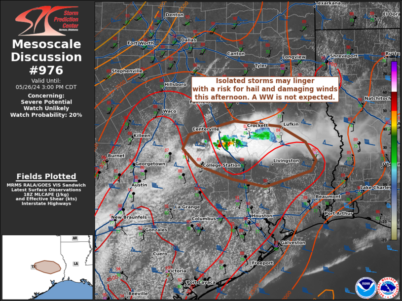
   Mesoscale Discussion 0976
   NWS Storm Prediction Center Norman OK
   0129 PM CDT Sun May 26 2024

   Areas affected...parts of southeast TX

   Concerning...Severe potential...Watch unlikely

   Valid 261829Z - 262000Z

   Probability of Watch Issuance...20 percent

   SUMMARY...Isolated storms over parts of southeast TX may persist
   with a risk for hail and damaging winds. Confidence in storm
   evolution is low and A WW is not expected.

   DISCUSSION...As of 1820 UTC, regional radar and satellite analysis
   showed isolated storms have developed along a low-level confluence
   axis near I-45 across southeast TX. Driven by increasing diurnal
   heating, localized confluence and subtle warm air advection aloft,
   these storms have continued to persist despite moderate MLCINH.
   Upper 70s to near 80s F surface dewpoints are supporting an
   incredibly moist air mass as temperatures rise into the low 90s F.
   While low-level lapse rates are poor, continued surface heating, and
   the deep/rich boundary-layer moisture will allow for 2500-4000 J/kg
   of MLCAPE. The magnitude of MLCAPE suggests established updrafts may
   continue and could intensify/redevelop. 40-50 kt of deep-layer shear
   could also support storm organization, though confidence in storm
   evolution is very low without large-scale forcing for ascent and
   warm temperatures aloft. Still, given the potential for strong
   updrafts and some risk for storm organization, isolated hail and
   damaging winds will be possible. Confidence in the overall evolution
   is very low, but convective trends will continued to be monitored.

   ..Lyons/Bunting.. 05/26/2024

   ...Please see www.spc.noaa.gov for graphic product...

   ATTN...WFO...LCH...SHV...HGX...FWD...

   LAT...LON   30779405 31089427 31359477 31449569 31219660 30969671
               30699643 30459572 30319506 30589416 30779405
|
|
Top/All Mesoscale Discussions/Forecast Products/Home
|
|


 @NWSSPC