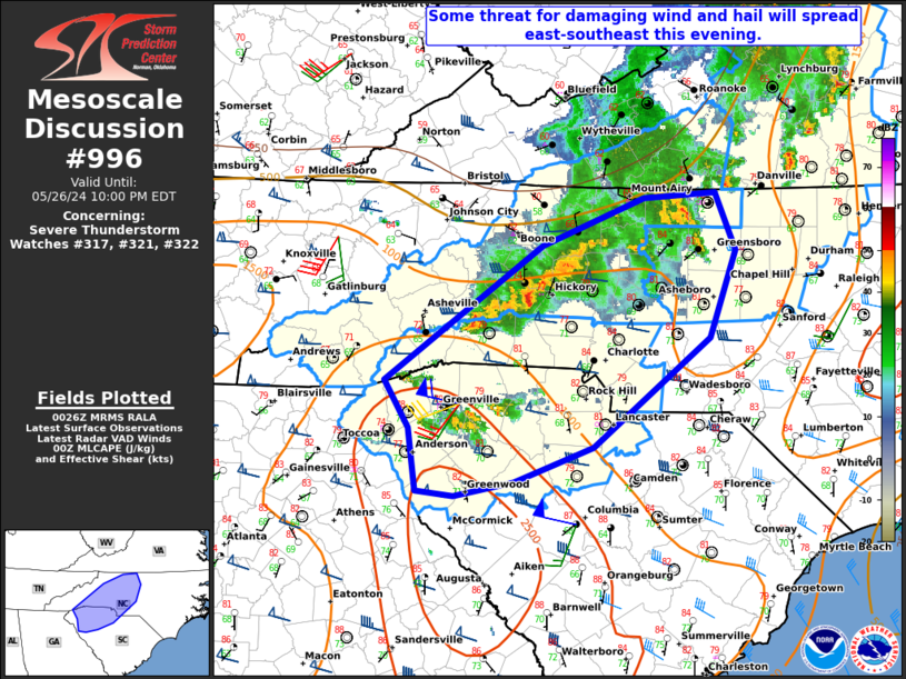
   Mesoscale Discussion 0996
   NWS Storm Prediction Center Norman OK
   0727 PM CDT Sun May 26 2024

   Areas affected...Carolina Piedmont vicinity

   Concerning...Severe Thunderstorm Watch 317...321...322...

   Valid 270027Z - 270200Z

   The severe weather threat for Severe Thunderstorm Watch 317, 321,
   322 continues.

   SUMMARY...Some threat for damaging wind and hail will spread
   east-southeast this evening. An isolated severe threat may
   eventually spread east of the ongoing watches.

   DISCUSSION...A couple of supercells are ongoing this evening across
   parts of upstate SC, with golfball hail recently observed in the
   Greenville-Spartanburg area. Some interaction between that supercell
   and a left-moving cell to its west will be possible in the short
   term, which could lead to a localized increase in damaging wind
   potential. Discrete supercell activity is eventually expected to
   weaken later this evening with the onset of nocturnal
   cooling/stabilization, but some threat for hail and isolated
   damaging wind will persist until the ongoing cells weaken.

   Farther north, some recent intensification has been noted with a
   storm cluster moving southeastward across western NC, to the
   northwest of Charlotte. The KCLT VWP depicts relatively weak
   low-level flow, but rather strong deep-layer flow/shear, which in
   combination with moderate buoyancy will support continued storm
   organization in the short term this evening. While MLCINH will
   gradually increase with time, a threat for damaging wind and perhaps
   some hail will continue to spread east-southeastward. Depending on
   the longevity of ongoing convection, local watch extension or
   downstream watch issuance may eventually need to be considered.

   ..Dean/Smith.. 05/27/2024

   ...Please see www.spc.noaa.gov for graphic product...

   ATTN...WFO...RAH...RNK...CAE...GSP...

   LAT...LON   34698269 35068292 36118143 36478046 36527977 36077959
               35387984 34548094 34278169 34168226 34208262 34698269
|


 @NWSSPC