 Note:
The expiration time in the watch graphic is amended if the watch is
replaced, cancelled or extended.
Note:
Note:
The expiration time in the watch graphic is amended if the watch is
replaced, cancelled or extended.
Note: Click for
Watch Status Reports.
SEL1
URGENT - IMMEDIATE BROADCAST REQUESTED
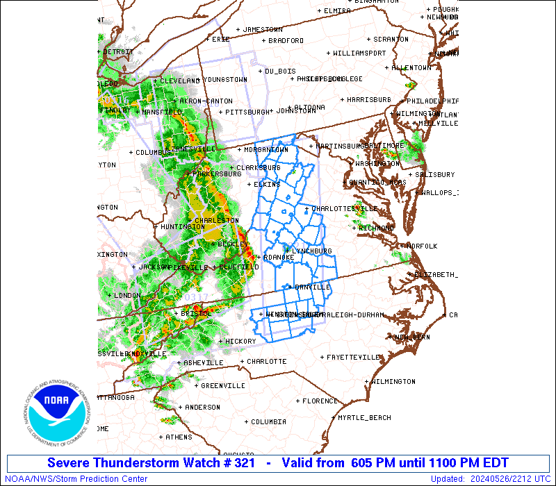
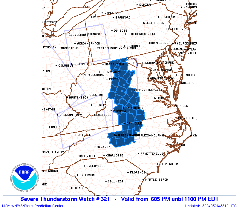
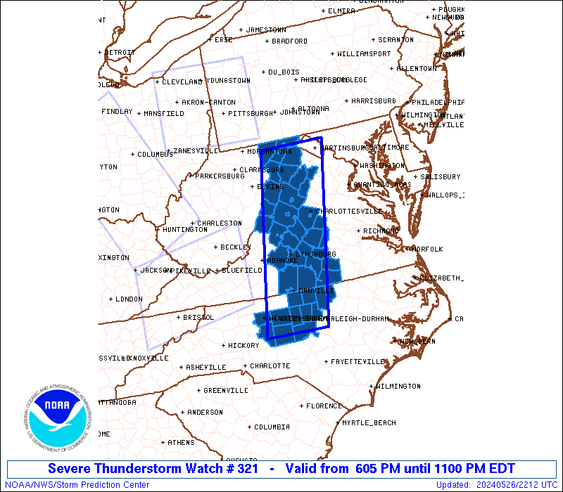
Severe Thunderstorm Watch Number 321
NWS Storm Prediction Center Norman OK
605 PM EDT Sun May 26 2024
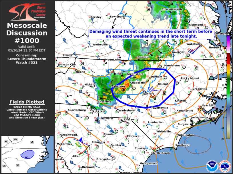
The NWS Storm Prediction Center has issued a
* Severe Thunderstorm Watch for portions of
Far Western Maryland
North-Central North Carolina
Western and South-Central Virginia
Eastern West Virginia
* Effective this Sunday evening from 605 PM until 1100 PM EDT.
* Primary threats include...
Scattered damaging wind gusts to 70 mph possible
SUMMARY...An organized and long-lived squall line will likely
continue into the Watch area this evening across western Virginia
northward into far western Maryland. Strong to severe gusts ranging
from 50-70 mph will be capable of wind damage. Farther south, a
couple of strong to severe thunderstorm clusters will probably move
into north-central North Carolina during the evening and potentially
pose a risk for large hail and damaging gusts.
The severe thunderstorm watch area is approximately along and 45
statute miles east and west of a line from 35 miles west northwest
of Martinsburg WV to 40 miles southeast of Greensboro NC. For a
complete depiction of the watch see the associated watch outline
update (WOUS64 KWNS WOU1).
PRECAUTIONARY/PREPAREDNESS ACTIONS...
REMEMBER...A Severe Thunderstorm Watch means conditions are
favorable for severe thunderstorms in and close to the watch area.
Persons in these areas should be on the lookout for threatening
weather conditions and listen for later statements and possible
warnings. Severe thunderstorms can and occasionally do produce
tornadoes.
&&
OTHER WATCH INFORMATION...CONTINUE...WW 316...WW 317...WW
318...WW 319...WW 320...
AVIATION...A few severe thunderstorms with hail surface and aloft to
1.5 inches. Extreme turbulence and surface wind gusts to 60 knots. A
few cumulonimbi with maximum tops to 350. Mean storm motion vector
25035.
...Smith
   SEL1

   URGENT - IMMEDIATE BROADCAST REQUESTED
   Severe Thunderstorm Watch Number 321
   NWS Storm Prediction Center Norman OK
   605 PM EDT Sun May 26 2024

   The NWS Storm Prediction Center has issued a

   * Severe Thunderstorm Watch for portions of
     Far Western Maryland
     North-Central North Carolina
     Western and South-Central Virginia
     Eastern West Virginia

   * Effective this Sunday evening from 605 PM until 1100 PM EDT.

   * Primary threats include...
     Scattered damaging wind gusts to 70 mph possible

   SUMMARY...An organized and long-lived squall line will likely
   continue into the Watch area this evening across western Virginia
   northward into far western Maryland.  Strong to severe gusts ranging
   from 50-70 mph will be capable of wind damage.  Farther south, a
   couple of strong to severe thunderstorm clusters will probably move
   into north-central North Carolina during the evening and potentially
   pose a risk for large hail and damaging gusts.

   The severe thunderstorm watch area is approximately along and 45
   statute miles east and west of a line from 35 miles west northwest
   of Martinsburg WV to 40 miles southeast of Greensboro NC. For a
   complete depiction of the watch see the associated watch outline
   update (WOUS64 KWNS WOU1).

   PRECAUTIONARY/PREPAREDNESS ACTIONS...

   REMEMBER...A Severe Thunderstorm Watch means conditions are
   favorable for severe thunderstorms in and close to the watch area.
   Persons in these areas should be on the lookout for threatening
   weather conditions and listen for later statements and possible
   warnings. Severe thunderstorms can and occasionally do produce
   tornadoes.

   &&

   OTHER WATCH INFORMATION...CONTINUE...WW 316...WW 317...WW
   318...WW 319...WW 320...

   AVIATION...A few severe thunderstorms with hail surface and aloft to
   1.5 inches. Extreme turbulence and surface wind gusts to 60 knots. A
   few cumulonimbi with maximum tops to 350. Mean storm motion vector
   25035.

   ...Smith
 Note:
The Aviation Watch (SAW) product is an approximation to the watch area.
The actual watch is depicted by the shaded areas.
Note:
The Aviation Watch (SAW) product is an approximation to the watch area.
The actual watch is depicted by the shaded areas.
SAW1
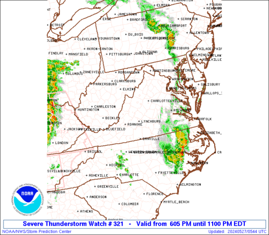
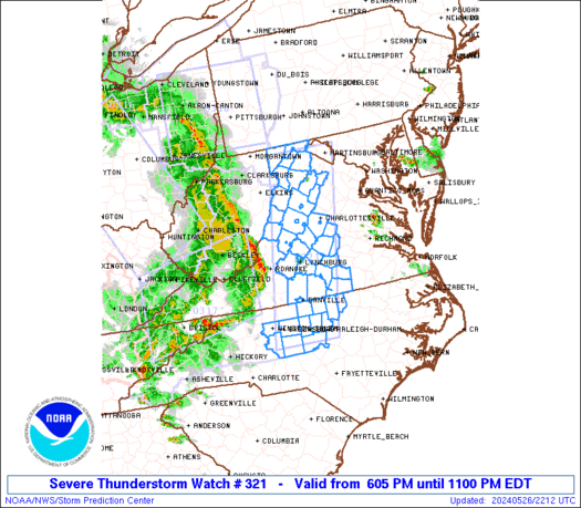
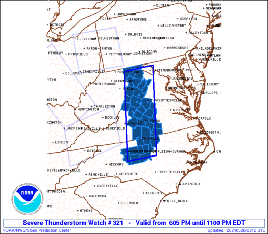
WW 321 SEVERE TSTM MD NC VA WV 262205Z - 270300Z
AXIS..45 STATUTE MILES EAST AND WEST OF LINE..
35WNW MRB/MARTINSBURG WV/ - 40SE GSO/GREENSBORO NC/
..AVIATION COORDS.. 40NM E/W /45SSE JST - 33WSW RDU/
HAIL SURFACE AND ALOFT..1.5 INCHES. WIND GUSTS..60 KNOTS.
MAX TOPS TO 350. MEAN STORM MOTION VECTOR 25035.
LAT...LON 39597774 35687862 35688023 39597943
THIS IS AN APPROXIMATION TO THE WATCH AREA. FOR A
COMPLETE DEPICTION OF THE WATCH SEE WOUS64 KWNS
FOR WOU1.
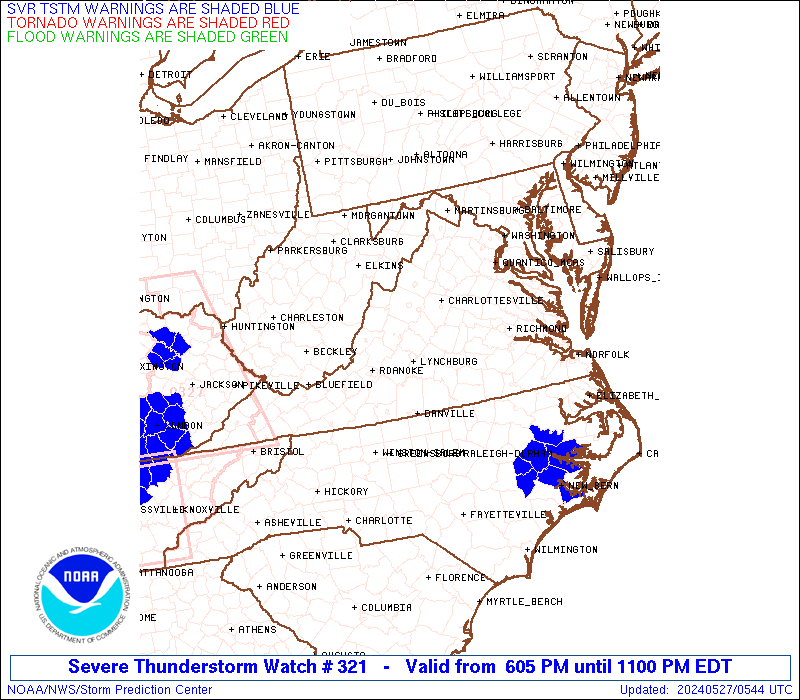
Watch 321 Status Report Messages:
STATUS REPORT #3 ON WW 321

VALID 270115Z - 270240Z

SEVERE WEATHER THREAT CONTINUES RIGHT OF A LINE FROM 35 W GSO TO
20 W DAN TO 25 SSE LYH TO 15 W CHO TO 45 W MRB TO 5 NW FKL.

..LYONS..05/27/24

ATTN...WFO...LWX...RAH...RNK...AKQ...

&&

STATUS REPORT FOR WS 321

SEVERE WEATHER THREAT CONTINUES FOR THE FOLLOWING AREAS

MDC001-270240-

MD
.    MARYLAND COUNTIES INCLUDED ARE

ALLEGANY
$$


NCC001-033-037-057-063-067-077-081-135-145-151-181-270240-

NC
.    NORTH CAROLINA COUNTIES INCLUDED ARE

ALAMANCE	     CASWELL		 CHATHAM
DAVIDSON	     DURHAM		 FORSYTH
GRANVILLE	     GUILFORD		 ORANGE
PERSON		     RANDOLPH		 VANCE
$$


VAC003-011-029-031-037-049-065-083-111-117-125-139-147-171-187-
540-270240-

VA
.    VIRGINIA COUNTIES INCLUDED ARE

ALBEMARLE	     APPOMATTOX 	 BUCKINGHAM
CAMPBELL	     CHARLOTTE		 CUMBERLAND
FLUVANNA	     HALIFAX		 LUNENBURG
MECKLENBURG	     NELSON		 PAGE
PRINCE EDWARD	     SHENANDOAH 	 WARREN


VIRGINIA INDEPENDENT CITIES INCLUDED ARE

CHARLOTTESVILLE
$$


WVC027-031-071-270240-

WV
.    WEST VIRGINIA COUNTIES INCLUDED ARE

HAMPSHIRE	     HARDY		 PENDLETON
$$


THE WATCH STATUS MESSAGE IS FOR GUIDANCE PURPOSES ONLY.  PLEASE
REFER TO WATCH COUNTY NOTIFICATION STATEMENTS FOR OFFICIAL
INFORMATION ON COUNTIES...INDEPENDENT CITIES AND MARINE ZONES
CLEARED FROM SEVERE THUNDERSTORM AND TORNADO WATCHES.
$$

STATUS REPORT #2 ON WW 321

VALID 270115Z - 270240Z

SEVERE WEATHER THREAT CONTINUES RIGHT OF A LINE FROM 35 W GSO TO
20 W DAN TO 25 SSE LYH TO 15 W CHO TO 45 W MRB TO 5 NW FKL.

..LYONS..05/27/24

ATTN...WFO...LWX...RAH...RNK...AKQ...

&&

STATUS REPORT FOR WS 321

SEVERE WEATHER THREAT CONTINUES FOR THE FOLLOWING AREAS

MDC001-270240-

MD
.    MARYLAND COUNTIES INCLUDED ARE

ALLEGANY
$$


NCC001-033-037-057-063-067-077-081-135-145-151-181-270240-

NC
.    NORTH CAROLINA COUNTIES INCLUDED ARE

ALAMANCE	     CASWELL		 CHATHAM
DAVIDSON	     DURHAM		 FORSYTH
GRANVILLE	     GUILFORD		 ORANGE
PERSON		     RANDOLPH		 VANCE
$$


VAC003-011-029-031-037-049-065-083-111-117-125-139-147-171-187-
540-270240-

VA
.    VIRGINIA COUNTIES INCLUDED ARE

ALBEMARLE	     APPOMATTOX 	 BUCKINGHAM
CAMPBELL	     CHARLOTTE		 CUMBERLAND
FLUVANNA	     HALIFAX		 LUNENBURG
MECKLENBURG	     NELSON		 PAGE
PRINCE EDWARD	     SHENANDOAH 	 WARREN


VIRGINIA INDEPENDENT CITIES INCLUDED ARE

CHARLOTTESVILLE
$$


WVC027-031-071-270240-

WV
.    WEST VIRGINIA COUNTIES INCLUDED ARE

HAMPSHIRE	     HARDY		 PENDLETON
$$


THE WATCH STATUS MESSAGE IS FOR GUIDANCE PURPOSES ONLY.  PLEASE
REFER TO WATCH COUNTY NOTIFICATION STATEMENTS FOR OFFICIAL
INFORMATION ON COUNTIES...INDEPENDENT CITIES AND MARINE ZONES
CLEARED FROM SEVERE THUNDERSTORM AND TORNADO WATCHES.
$$

STATUS REPORT #1 ON WW 321

VALID 270015Z - 270140Z

THE SEVERE WEATHER THREAT CONTINUES ACROSS THE ENTIRE WATCH AREA.

..LYONS..05/27/24

ATTN...WFO...LWX...RAH...RNK...AKQ...

&&

STATUS REPORT FOR WS 321

SEVERE WEATHER THREAT CONTINUES FOR THE FOLLOWING AREAS

MDC001-023-270140-

MD
.    MARYLAND COUNTIES INCLUDED ARE

ALLEGANY	     GARRETT
$$


NCC001-033-037-057-063-067-077-081-135-145-151-181-270140-

NC
.    NORTH CAROLINA COUNTIES INCLUDED ARE

ALAMANCE	     CASWELL		 CHATHAM
DAVIDSON	     DURHAM		 FORSYTH
GRANVILLE	     GUILFORD		 ORANGE
PERSON		     RANDOLPH		 VANCE
$$


VAC003-009-011-015-017-019-029-031-037-049-065-083-091-111-117-
125-139-143-147-163-165-171-187-530-540-590-660-678-680-790-820-
270140-

VA
.    VIRGINIA COUNTIES INCLUDED ARE

ALBEMARLE	     AMHERST		 APPOMATTOX
AUGUSTA 	     BATH		 BEDFORD
BUCKINGHAM	     CAMPBELL		 CHARLOTTE
CUMBERLAND	     FLUVANNA		 HALIFAX
HIGHLAND	     LUNENBURG		 MECKLENBURG
NELSON		     PAGE		 PITTSYLVANIA
PRINCE EDWARD	     ROCKBRIDGE 	 ROCKINGHAM
SHENANDOAH	     WARREN


VIRGINIA INDEPENDENT CITIES INCLUDED ARE

BUENA VISTA	     CHARLOTTESVILLE	 DANVILLE
HARRISONBURG	     LEXINGTON		 LYNCHBURG
STAUNTON	     WAYNESBORO
$$


WVC023-027-031-057-071-270140-

WV
.    WEST VIRGINIA COUNTIES INCLUDED ARE

GRANT		     HAMPSHIRE		 HARDY
MINERAL 	     PENDLETON
$$


THE WATCH STATUS MESSAGE IS FOR GUIDANCE PURPOSES ONLY.  PLEASE
REFER TO WATCH COUNTY NOTIFICATION STATEMENTS FOR OFFICIAL
INFORMATION ON COUNTIES...INDEPENDENT CITIES AND MARINE ZONES
CLEARED FROM SEVERE THUNDERSTORM AND TORNADO WATCHES.
$$
Note:
Click for Complete Product Text.
Tornadoes
Probability of 2 or more tornadoes
|
Low (<5%)
|
Probability of 1 or more strong (EF2-EF5) tornadoes
|
Low (<2%)
|
Wind
Probability of 10 or more severe wind events
|
Mod (50%)
|
Probability of 1 or more wind events > 65 knots
|
Low (20%)
|
Hail
Probability of 10 or more severe hail events
|
Low (<5%)
|
Probability of 1 or more hailstones > 2 inches
|
Low (<5%)
|
Combined Severe Hail/Wind
Probability of 6 or more combined severe hail/wind events
|
Mod (60%)
|
For each watch, probabilities for particular events inside the watch
(listed above in each table) are determined by the issuing forecaster.
The "Low" category contains probability values ranging from less than 2%
to 20% (EF2-EF5 tornadoes), less than 5% to 20% (all other probabilities),
"Moderate" from 30% to 60%, and "High" from 70% to greater than 95%.
High values are bolded and lighter in color to provide awareness of
an increased threat for a particular event.


 @NWSSPC