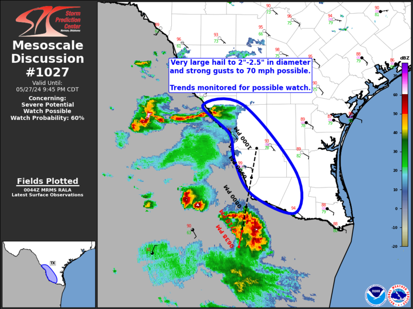
   Mesoscale Discussion 1027
   NWS Storm Prediction Center Norman OK
   0746 PM CDT Mon May 27 2024

   Areas affected...Middle/Lower Rio Grande Valley

   Concerning...Severe potential...Watch possible

   Valid 280046Z - 280245Z

   Probability of Watch Issuance...60 percent

   SUMMARY...Large to very large hail (2" to 2.5" in diameter) and
   strong gusts up to 70 mph are possible across the Middle/Lower Rio
   Grande Valley this evening. The need for a watch is uncertain, but
   convective trends will be monitored closely.

   DISCUSSION...Visible satellite and regional radar imagery shows an
   intense left-moving supercell moving across northern Tamaulipas
   towards the Lower Rio Grande Valley. Recent motion of this storm was
   estimated at 30 kt, bringing it across the border around 0130Z.
   Extreme buoyancy (i.e. MLCAPE around 5000 J/kg) is in place
   downstream, with at least some potential for this storm to maintain
   its intensity for the next few hours. Main deterrent is the building
   convective inhibition and warm temperatures aloft, which, given the
   intensity of the storm, are not expected to result in quick storm
   weakening. Large to very large hail (2" to 2.5" in diameter) and
   strong gusts up to 70 mph may impact the Lower Rio Grande Valley
   within the next hour.

   Farther north (about 30 miles south of LRD), convergence along an
   outflow boundary has resulted in convective initiation, with much of
   the activity west of the border. However, one cell has developed in
   far western Webb County. Large to very large hail and strong gusts
   are possible with this storm, as well as any other development that
   occurs in this area.

   Given the widely spaced and isolated nature of the severe threat,
   the need for watch is uncertain. However, convective trends will be
   monitored closely.

   ..Mosier/Smith.. 05/28/2024

   ...Please see www.spc.noaa.gov for graphic product...

   ATTN...WFO...CRP...BRO...

   LAT...LON   27089942 27549952 28020006 28049926 26869822 26169825
               26489909 27089942
|


 @NWSSPC