|
| Mesoscale Discussion 1028 |
|
< Previous MD Next MD >
|
|
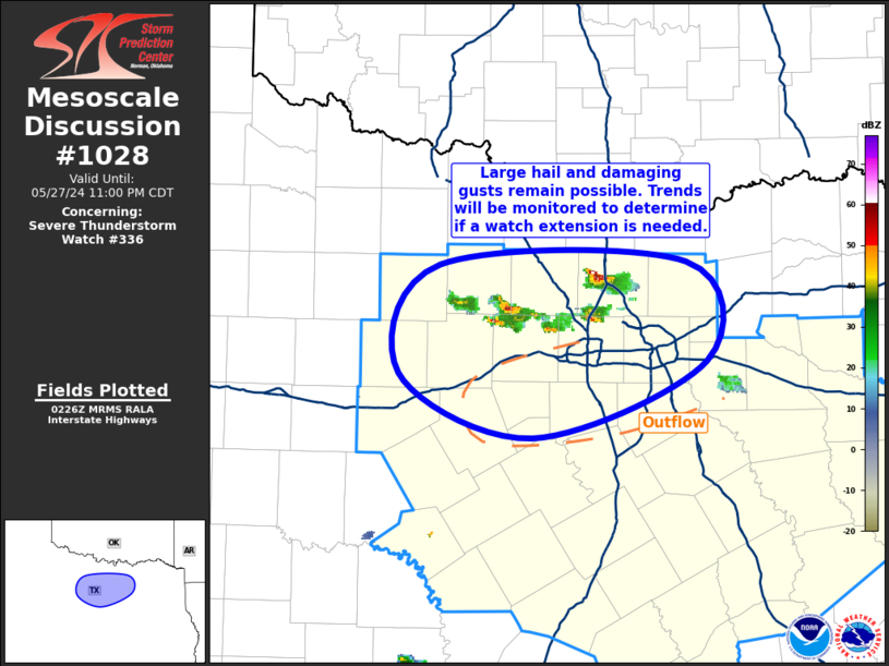
   Mesoscale Discussion 1028
   NWS Storm Prediction Center Norman OK
   0928 PM CDT Mon May 27 2024

   Areas affected...North Texas

   Concerning...Severe Thunderstorm Watch 336...

   Valid 280228Z - 280400Z

   The severe weather threat for Severe Thunderstorm Watch 336
   continues.

   SUMMARY...Large hail and damaging gusts remain possible with the
   thunderstorms ongoing over north Texas. Convective trends will be
   monitored to determine if a local extension in time of the ongoing
   watch is needed.

   DISCUSSION...Another round of thunderstorms has developed amid the
   low-level moisture convergence across Jack, Wise, and Denton
   Counties in North Texas. This development is occurring to the north
   of the outflow-dried air that extends from Tarrant and Dallas
   Counties southeastward into Erath County. The presence of this drier
   air just downstream of the storms and onset of nocturnal cooling
   suggest that the longevity of this activity may be limited. However,
   vertical shear remains strong, and there is some potential for the
   most organized storms to persist longer than the thermodynamic
   environment would suggest. Hail remains the primary threat, although
   a strong gust or two is possible as well. Severe Thunderstorm Watch
   336 is currently set to expire at 03Z, but convective trends will be
   monitored to determine if a local extension in time is necessary.

   ..Mosier.. 05/28/2024

   ...Please see www.spc.noaa.gov for graphic product...

   ATTN...WFO...FWD...

   LAT...LON   32609880 33329847 33359654 32689638 32189774 32609880
|
|
Top/All Mesoscale Discussions/Forecast Products/Home
|
|


 @NWSSPC