 Note:
The expiration time in the watch graphic is amended if the watch is
replaced, cancelled or extended.
Note:
Note:
The expiration time in the watch graphic is amended if the watch is
replaced, cancelled or extended.
Note: Click for
Watch Status Reports.
SEL6
URGENT - IMMEDIATE BROADCAST REQUESTED
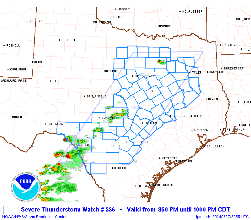
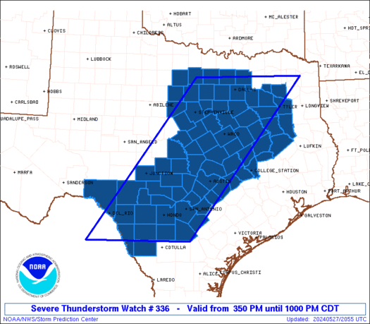
Severe Thunderstorm Watch Number 336
NWS Storm Prediction Center Norman OK
350 PM CDT Mon May 27 2024
The NWS Storm Prediction Center has issued a
* Severe Thunderstorm Watch for portions of
North and Central Texas
* Effective this Monday afternoon and evening from 350 PM until
1000 PM CDT.
* Primary threats include...
Scattered large hail likely with isolated very large hail events
to 3.5 inches in diameter possible
Scattered damaging winds and isolated significant gusts to 75
mph possible
A tornado or two possible
SUMMARY...Thunderstorms are expected to quickly develop and
intensify through late afternoon and early evening within a moist
and extremely unstable environment.
The severe thunderstorm watch area is approximately along and 100
statute miles east and west of a line from 35 miles northeast of
Dallas TX to 70 miles southwest of Hondo TX. For a complete
depiction of the watch see the associated watch outline update
(WOUS64 KWNS WOU6).
PRECAUTIONARY/PREPAREDNESS ACTIONS...
REMEMBER...A Severe Thunderstorm Watch means conditions are
favorable for severe thunderstorms in and close to the watch area.
Persons in these areas should be on the lookout for threatening
weather conditions and listen for later statements and possible
warnings. Severe thunderstorms can and occasionally do produce
tornadoes.
&&
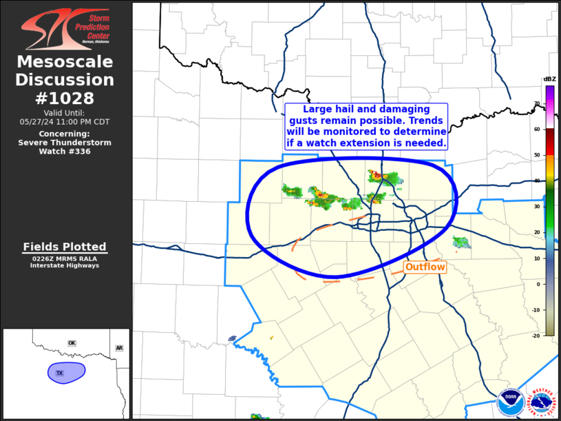
OTHER WATCH INFORMATION...CONTINUE...WW 333...WW 334...WW 335...
AVIATION...A few severe thunderstorms with hail surface and aloft to
3.5 inches. Extreme turbulence and surface wind gusts to 65 knots. A
few cumulonimbi with maximum tops to 550. Mean storm motion vector
26025.
...Guyer
 Note:
The Aviation Watch (SAW) product is an approximation to the watch area.
The actual watch is depicted by the shaded areas.
Note:
The Aviation Watch (SAW) product is an approximation to the watch area.
The actual watch is depicted by the shaded areas.
SAW6
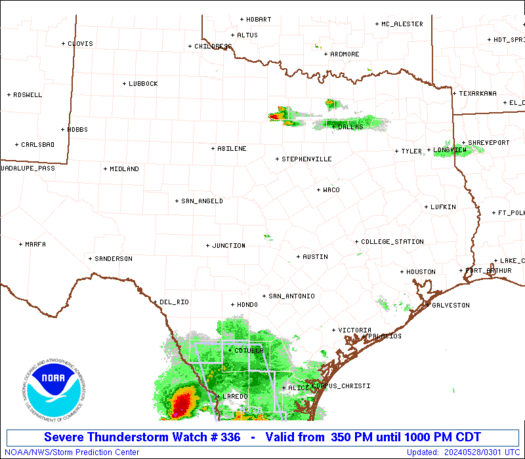
WW 336 SEVERE TSTM TX 272050Z - 280300Z
AXIS..100 STATUTE MILES EAST AND WEST OF LINE..
35NE DAL/DALLAS TX/ - 70SW HDO/HONDO TX/
..AVIATION COORDS.. 85NM E/W /37ENE TTT - 60SE DLF/
HAIL SURFACE AND ALOFT..3.5 INCHES. WIND GUSTS..65 KNOTS.
MAX TOPS TO 550. MEAN STORM MOTION VECTOR 26025.
LAT...LON 33209469 28629835 28620164 33209815
THIS IS AN APPROXIMATION TO THE WATCH AREA. FOR A
COMPLETE DEPICTION OF THE WATCH SEE WOUS64 KWNS
FOR WOU6.
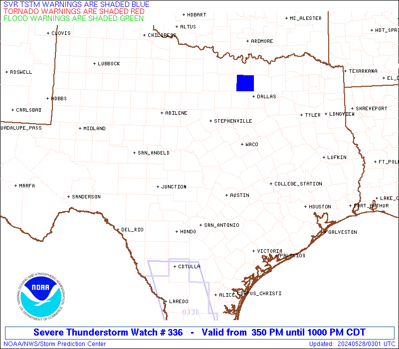
Watch 336 Status Report Messages:
STATUS REPORT #1 ON WW 336

VALID 272355Z - 280040Z

THE SEVERE WEATHER THREAT CONTINUES ACROSS THE ENTIRE WATCH AREA.

..MOSIER..05/27/24

ATTN...WFO...FWD...EWX...HGX...SHV...SJT...

&&

STATUS REPORT FOR WS 336

SEVERE WEATHER THREAT CONTINUES FOR THE FOLLOWING AREAS

TXC001-013-019-021-027-029-031-035-041-051-053-055-073-085-091-
093-099-113-121-127-133-137-139-143-145-161-163-171-187-193-209-
213-217-221-225-237-251-257-259-265-267-271-281-287-289-293-299-
309-313-319-323-325-331-333-349-363-367-379-385-395-397-411-423-
425-429-439-453-463-465-467-491-493-497-499-503-507-280040-

TX
.    TEXAS COUNTIES INCLUDED ARE

ANDERSON	     ATASCOSA		 BANDERA
BASTROP 	     BELL		 BEXAR
BLANCO		     BOSQUE		 BRAZOS
BURLESON	     BURNET		 CALDWELL
CHEROKEE	     COLLIN		 COMAL
COMANCHE	     CORYELL		 DALLAS
DENTON		     DIMMIT		 EASTLAND
EDWARDS 	     ELLIS		 ERATH
FALLS		     FREESTONE		 FRIO
GILLESPIE	     GUADALUPE		 HAMILTON
HAYS		     HENDERSON		 HILL
HOOD		     HOUSTON		 JACK
JOHNSON 	     KAUFMAN		 KENDALL
KERR		     KIMBLE		 KINNEY
LAMPASAS	     LEE		 LEON
LIMESTONE	     LLANO		 MCLENNAN
MADISON 	     MASON		 MAVERICK
MEDINA		     MILAM		 MILLS
NAVARRO 	     PALO PINTO 	 PARKER
RAINS		     REAL		 ROBERTSON
ROCKWALL	     SAN SABA		 SMITH
SOMERVELL	     STEPHENS		 TARRANT
TRAVIS		     UVALDE		 VAL VERDE
VAN ZANDT	     WILLIAMSON 	 WILSON
WISE		     WOOD		 YOUNG
ZAVALA
$$


THE WATCH STATUS MESSAGE IS FOR GUIDANCE PURPOSES ONLY.  PLEASE
REFER TO WATCH COUNTY NOTIFICATION STATEMENTS FOR OFFICIAL
INFORMATION ON COUNTIES...INDEPENDENT CITIES AND MARINE ZONES
CLEARED FROM SEVERE THUNDERSTORM AND TORNADO WATCHES.
$$
Note:
Click for Complete Product Text.
Tornadoes
Probability of 2 or more tornadoes
|
Low (20%)
|
Probability of 1 or more strong (EF2-EF5) tornadoes
|
Low (5%)
|
Wind
Probability of 10 or more severe wind events
|
Mod (40%)
|
Probability of 1 or more wind events > 65 knots
|
Mod (30%)
|
Hail
Probability of 10 or more severe hail events
|
Mod (60%)
|
Probability of 1 or more hailstones > 2 inches
|
Mod (40%)
|
Combined Severe Hail/Wind
Probability of 6 or more combined severe hail/wind events
|
High (90%)
|
For each watch, probabilities for particular events inside the watch
(listed above in each table) are determined by the issuing forecaster.
The "Low" category contains probability values ranging from less than 2%
to 20% (EF2-EF5 tornadoes), less than 5% to 20% (all other probabilities),
"Moderate" from 30% to 60%, and "High" from 70% to greater than 95%.
High values are bolded and lighter in color to provide awareness of
an increased threat for a particular event.


 @NWSSPC