 Note:
The expiration time in the watch graphic is amended if the watch is
replaced, cancelled or extended.
Note:
Note:
The expiration time in the watch graphic is amended if the watch is
replaced, cancelled or extended.
Note: Click for
Watch Status Reports.
SEL7
URGENT - IMMEDIATE BROADCAST REQUESTED
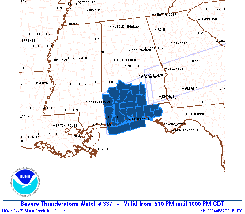
Severe Thunderstorm Watch Number 337
NWS Storm Prediction Center Norman OK
510 PM CDT Mon May 27 2024
The NWS Storm Prediction Center has issued a
* Severe Thunderstorm Watch for portions of
Southern Alabama
Western Florida Panhandle
Coastal Waters
* Effective this Monday afternoon and evening from 510 PM until
1000 PM CDT.
* Primary threats include...
Scattered large hail and isolated very large hail events to 2
inches in diameter possible
Scattered damaging wind gusts to 70 mph possible
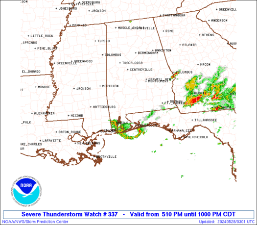
SUMMARY...A couple of clusters of strong to severe thunderstorms
will likely continue to develop late this afternoon into the
evening. The stronger storms will potentially yield a risk for
large hail and strong to severe gusts (55-70 mph) capable of wind
damage.
The severe thunderstorm watch area is approximately along and 65
statute miles north and south of a line from 15 miles northwest of
Mobile AL to 30 miles south southeast of Troy AL. For a complete
depiction of the watch see the associated watch outline update
(WOUS64 KWNS WOU7).
PRECAUTIONARY/PREPAREDNESS ACTIONS...
REMEMBER...A Severe Thunderstorm Watch means conditions are
favorable for severe thunderstorms in and close to the watch area.
Persons in these areas should be on the lookout for threatening
weather conditions and listen for later statements and possible
warnings. Severe thunderstorms can and occasionally do produce
tornadoes.
&&
OTHER WATCH INFORMATION...CONTINUE...WW 333...WW 334...WW
335...WW 336...
AVIATION...A few severe thunderstorms with hail surface and aloft to
2 inches. Extreme turbulence and surface wind gusts to 60 knots. A
few cumulonimbi with maximum tops to 500. Mean storm motion vector
27020.
...Smith
 Note:
The Aviation Watch (SAW) product is an approximation to the watch area.
The actual watch is depicted by the shaded areas.
Note:
The Aviation Watch (SAW) product is an approximation to the watch area.
The actual watch is depicted by the shaded areas.
   SAW7
   WW 337 SEVERE TSTM AL FL CW 272210Z - 280300Z
   AXIS..65 STATUTE MILES NORTH AND SOUTH OF LINE..
   15NW MOB/MOBILE AL/ - 30SSE TOI/TROY AL/
   ..AVIATION COORDS.. 55NM N/S /7NNW SJI - 52SSE MGM/
   HAIL SURFACE AND ALOFT..2 INCHES. WIND GUSTS..60 KNOTS.
   MAX TOPS TO 500. MEAN STORM MOTION VECTOR 27020.

   LAT...LON 31778843 32418583 30538583 29898843

   THIS IS AN APPROXIMATION TO THE WATCH AREA.  FOR A
   COMPLETE DEPICTION OF THE WATCH SEE WOUS64 KWNS
   FOR WOU7.
Watch 337 Status Report Messages:
STATUS REPORT #2 ON WW 337

VALID 280135Z - 280240Z

SEVERE WEATHER THREAT CONTINUES RIGHT OF A LINE FROM 30 NW MOB TO
20 NW CEW TO 15 NNW DHN.

..MOORE..05/28/24

ATTN...WFO...MOB...TAE...

&&

STATUS REPORT FOR WS 337

SEVERE WEATHER THREAT CONTINUES FOR THE FOLLOWING AREAS

ALC003-097-280240-

AL
.    ALABAMA COUNTIES INCLUDED ARE

BALDWIN 	     MOBILE
$$


FLC033-059-063-091-113-131-133-280240-

FL
.    FLORIDA COUNTIES INCLUDED ARE

ESCAMBIA	     HOLMES		 JACKSON
OKALOOSA	     SANTA ROSA 	 WALTON
WASHINGTON
$$


GMZ630-631-632-633-634-635-636-650-655-280240-

CW

.    ADJACENT COASTAL WATERS INCLUDED ARE

NORTH MOBILE BAY

SOUTH MOBILE BAY

MISSISSIPPI SOUND

PERDIDO BAY AREA

PENSACOLA BAY AREA INCLUDING SANTA ROSA SOUND

WESTERN CHOCTAWHATCHEE BAY

EASTERN CHOCTAWHATCHEE BAY

COASTAL WATERS FROM PENSACOLA FL TO PASCAGOULA MS OUT 20 NM

COASTAL WATERS FROM OKALOOSA-WALTON COUNTY LINE TO PENSACOLA FL
OUT 20 NM

$$
THE WATCH STATUS MESSAGE IS FOR GUIDANCE PURPOSES ONLY.  PLEASE
REFER TO WATCH COUNTY NOTIFICATION STATEMENTS FOR OFFICIAL
INFORMATION ON COUNTIES...INDEPENDENT CITIES AND MARINE ZONES
CLEARED FROM SEVERE THUNDERSTORM AND TORNADO WATCHES.
$$

STATUS REPORT #1 ON WW 337

VALID 280025Z - 280140Z

SEVERE WEATHER THREAT CONTINUES RIGHT OF A LINE FROM 40 NW MOB TO
15 S AUO.

..MOORE..05/28/24

ATTN...WFO...MOB...TAE...

&&

STATUS REPORT FOR WS 337

SEVERE WEATHER THREAT CONTINUES FOR THE FOLLOWING AREAS

ALC003-013-035-039-041-053-097-280140-

AL
.    ALABAMA COUNTIES INCLUDED ARE

BALDWIN 	     BUTLER		 CONECUH
COVINGTON	     CRENSHAW		 ESCAMBIA
MOBILE
$$


FLC033-059-063-091-113-131-133-280140-

FL
.    FLORIDA COUNTIES INCLUDED ARE

ESCAMBIA	     HOLMES		 JACKSON
OKALOOSA	     SANTA ROSA 	 WALTON
WASHINGTON
$$


GMZ630-631-632-633-634-635-636-650-655-280140-

CW

.    ADJACENT COASTAL WATERS INCLUDED ARE

NORTH MOBILE BAY

SOUTH MOBILE BAY

MISSISSIPPI SOUND

PERDIDO BAY AREA

PENSACOLA BAY AREA INCLUDING SANTA ROSA SOUND

WESTERN CHOCTAWHATCHEE BAY

EASTERN CHOCTAWHATCHEE BAY

COASTAL WATERS FROM PENSACOLA FL TO PASCAGOULA MS OUT 20 NM

COASTAL WATERS FROM OKALOOSA-WALTON COUNTY LINE TO PENSACOLA FL
OUT 20 NM

$$
THE WATCH STATUS MESSAGE IS FOR GUIDANCE PURPOSES ONLY.  PLEASE
REFER TO WATCH COUNTY NOTIFICATION STATEMENTS FOR OFFICIAL
INFORMATION ON COUNTIES...INDEPENDENT CITIES AND MARINE ZONES
CLEARED FROM SEVERE THUNDERSTORM AND TORNADO WATCHES.
$$
Note:
Click for Complete Product Text.
Tornadoes
Probability of 2 or more tornadoes
|
Low (10%)
|
Probability of 1 or more strong (EF2-EF5) tornadoes
|
Low (<2%)
|
Wind
Probability of 10 or more severe wind events
|
Mod (40%)
|
Probability of 1 or more wind events > 65 knots
|
Low (20%)
|
Hail
Probability of 10 or more severe hail events
|
Mod (40%)
|
Probability of 1 or more hailstones > 2 inches
|
Mod (30%)
|
Combined Severe Hail/Wind
Probability of 6 or more combined severe hail/wind events
|
High (70%)
|
For each watch, probabilities for particular events inside the watch
(listed above in each table) are determined by the issuing forecaster.
The "Low" category contains probability values ranging from less than 2%
to 20% (EF2-EF5 tornadoes), less than 5% to 20% (all other probabilities),
"Moderate" from 30% to 60%, and "High" from 70% to greater than 95%.
High values are bolded and lighter in color to provide awareness of
an increased threat for a particular event.


 @NWSSPC