Note:
The expiration time in the watch graphic is amended if the watch is
replaced, cancelled or extended.
Note:
Note:
The expiration time in the watch graphic is amended if the watch is
replaced, cancelled or extended.
Note: Click for
Watch Status Reports.
SEL4
URGENT - IMMEDIATE BROADCAST REQUESTED
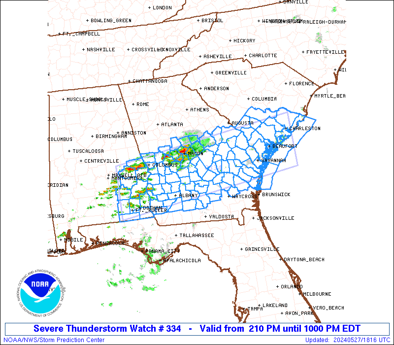
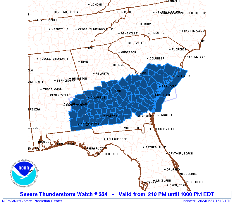
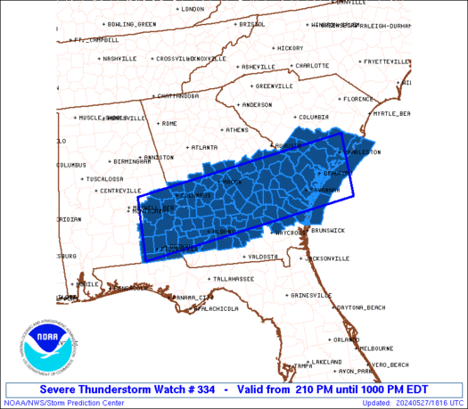
Severe Thunderstorm Watch Number 334
NWS Storm Prediction Center Norman OK
210 PM EDT Mon May 27 2024
The NWS Storm Prediction Center has issued a
* Severe Thunderstorm Watch for portions of
Southeast Alabama
Central and Southern Georgia
Southern South Carolina
Coastal Waters
* Effective this Monday afternoon and evening from 210 PM until
1000 PM EDT.
* Primary threats include...
Scattered damaging wind gusts to 65 mph likely
Isolated large hail events to 1.5 inches in diameter possible
A tornado or two possible
SUMMARY...Scattered severe storms are expected to develop, initially
this afternoon near a remnant boundary across central/south-central
Georgia, eastward into southern South Carolina as well as southeast
Alabama.
The severe thunderstorm watch area is approximately along and 55
statute miles north and south of a line from 5 miles southwest of
Troy AL to 25 miles south southeast of Charleston SC. For a complete
depiction of the watch see the associated watch outline update
(WOUS64 KWNS WOU4).
PRECAUTIONARY/PREPAREDNESS ACTIONS...
REMEMBER...A Severe Thunderstorm Watch means conditions are
favorable for severe thunderstorms in and close to the watch area.
Persons in these areas should be on the lookout for threatening
weather conditions and listen for later statements and possible
warnings. Severe thunderstorms can and occasionally do produce
tornadoes.
&&
OTHER WATCH INFORMATION...CONTINUE...WW 333...
AVIATION...A few severe thunderstorms with hail surface and aloft to
1.5 inches. Extreme turbulence and surface wind gusts to 55 knots. A
few cumulonimbi with maximum tops to 500. Mean storm motion vector
27025.
...Guyer

   SEL4

   URGENT - IMMEDIATE BROADCAST REQUESTED
   Severe Thunderstorm Watch Number 334
   NWS Storm Prediction Center Norman OK
   210 PM EDT Mon May 27 2024

   The NWS Storm Prediction Center has issued a

   * Severe Thunderstorm Watch for portions of
     Southeast Alabama
     Central and Southern Georgia
     Southern South Carolina
     Coastal Waters

   * Effective this Monday afternoon and evening from 210 PM until
     1000 PM EDT.

   * Primary threats include...
     Scattered damaging wind gusts to 65 mph likely
     Isolated large hail events to 1.5 inches in diameter possible
     A tornado or two possible

   SUMMARY...Scattered severe storms are expected to develop, initially
   this afternoon near a remnant boundary across central/south-central
   Georgia, eastward into southern South Carolina as well as southeast
   Alabama.

   The severe thunderstorm watch area is approximately along and 55
   statute miles north and south of a line from 5 miles southwest of
   Troy AL to 25 miles south southeast of Charleston SC. For a complete
   depiction of the watch see the associated watch outline update
   (WOUS64 KWNS WOU4).

   PRECAUTIONARY/PREPAREDNESS ACTIONS...

   REMEMBER...A Severe Thunderstorm Watch means conditions are
   favorable for severe thunderstorms in and close to the watch area.
   Persons in these areas should be on the lookout for threatening
   weather conditions and listen for later statements and possible
   warnings. Severe thunderstorms can and occasionally do produce
   tornadoes.

   &&

   OTHER WATCH INFORMATION...CONTINUE...WW 333...

   AVIATION...A few severe thunderstorms with hail surface and aloft to
   1.5 inches. Extreme turbulence and surface wind gusts to 55 knots. A
   few cumulonimbi with maximum tops to 500. Mean storm motion vector
   27025.

   ...Guyer
 Note:
The Aviation Watch (SAW) product is an approximation to the watch area.
The actual watch is depicted by the shaded areas.
Note:
The Aviation Watch (SAW) product is an approximation to the watch area.
The actual watch is depicted by the shaded areas.
   SAW4
   WW 334 SEVERE TSTM AL GA SC CW 271810Z - 280200Z
   AXIS..55 STATUTE MILES NORTH AND SOUTH OF LINE..
   5SW TOI/TROY AL/ - 25SSE CHS/CHARLESTON SC/
   ..AVIATION COORDS.. 50NM N/S /27SSE MGM - 21SSE CHS/
   HAIL SURFACE AND ALOFT..1.5 INCHES. WIND GUSTS..55 KNOTS.
   MAX TOPS TO 500. MEAN STORM MOTION VECTOR 27025.

   LAT...LON 32618608 33367987 31777987 31028608

   THIS IS AN APPROXIMATION TO THE WATCH AREA.  FOR A
   COMPLETE DEPICTION OF THE WATCH SEE WOUS64 KWNS
   FOR WOU4.
Watch 334 Status Report Messages:
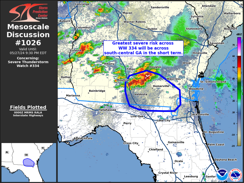
STATUS REPORT #2 ON WW 334

VALID 280010Z - 280140Z

SEVERE WEATHER THREAT CONTINUES RIGHT OF A LINE FROM 15 WNW AGS
TO 35 SE SSI.

FOR ADDITIONAL INFORMATION SEE MESOSCALE DISCUSSION 1026

..MOORE..05/28/24

ATTN...WFO...BMX...TAE...JAX...FFC...CHS...CAE...

&&

STATUS REPORT FOR WS 334

SEVERE WEATHER THREAT CONTINUES FOR THE FOLLOWING AREAS

ALC005-011-031-045-061-067-069-081-087-109-113-280140-

AL
.    ALABAMA COUNTIES INCLUDED ARE

BARBOUR 	     BULLOCK		 COFFEE
DALE		     GENEVA		 HENRY
HOUSTON 	     LEE		 MACON
PIKE		     RUSSELL
$$


GAC001-003-005-007-009-017-019-021-023-025-027-035-037-039-043-
049-053-061-065-069-071-075-079-081-087-091-093-095-099-101-107-
109-125-127-131-141-145-153-155-159-161-163-167-169-171-173-175-
177-183-185-193-197-199-201-205-207-209-215-225-229-231-235-237-
239-243-249-253-255-259-261-263-267-269-271-273-275-277-279-283-
285-287-289-293-299-301-303-305-307-309-315-319-321-280140-

GA
.    GEORGIA COUNTIES INCLUDED ARE

APPLING 	     ATKINSON		 BACON
BAKER		     BALDWIN		 BEN HILL
BERRIEN 	     BIBB		 BLECKLEY
BRANTLEY	     BROOKS		 BUTTS
CALHOUN 	     CAMDEN		 CANDLER
CHARLTON	     CHATTAHOOCHEE	 CLAY
CLINCH		     COFFEE		 COLQUITT
COOK		     CRAWFORD		 CRISP
DECATUR 	     DODGE		 DOOLY
DOUGHERTY	     EARLY		 ECHOLS
EMANUEL 	     EVANS		 GLASCOCK
GLYNN		     GRADY		 HANCOCK
HARRIS		     HOUSTON		 IRWIN
JASPER		     JEFF DAVIS 	 JEFFERSON
JOHNSON 	     JONES		 LAMAR
LANIER		     LAURENS		 LEE
LONG		     LOWNDES		 MACON
MARION		     MERIWETHER 	 MILLER
MITCHELL	     MONROE		 MONTGOMERY
MUSCOGEE	     PEACH		 PIERCE
PIKE		     PULASKI		 PUTNAM
QUITMAN 	     RANDOLPH		 SCHLEY
SEMINOLE	     SPALDING		 STEWART
SUMTER		     TALBOT		 TATTNALL
TAYLOR		     TELFAIR		 TERRELL
THOMAS		     TIFT		 TOOMBS
TREUTLEN	     TROUP		 TURNER
TWIGGS		     UPSON		 WARE
WARREN		     WASHINGTON 	 WAYNE
WEBSTER 	     WHEELER		 WILCOX
WILKINSON	     WORTH
$$


THE WATCH STATUS MESSAGE IS FOR GUIDANCE PURPOSES ONLY.  PLEASE
REFER TO WATCH COUNTY NOTIFICATION STATEMENTS FOR OFFICIAL
INFORMATION ON COUNTIES...INDEPENDENT CITIES AND MARINE ZONES
CLEARED FROM SEVERE THUNDERSTORM AND TORNADO WATCHES.
$$

STATUS REPORT #1 ON WW 334

VALID 272225Z - 272340Z

THE SEVERE WEATHER THREAT CONTINUES ACROSS THE ENTIRE WATCH AREA.

..MOORE..05/27/24

ATTN...WFO...BMX...TAE...JAX...FFC...CHS...CAE...

&&

STATUS REPORT FOR WS 334

SEVERE WEATHER THREAT CONTINUES FOR THE FOLLOWING AREAS

ALC005-011-031-045-061-067-069-081-087-109-113-272340-

AL
.    ALABAMA COUNTIES INCLUDED ARE

BARBOUR 	     BULLOCK		 COFFEE
DALE		     GENEVA		 HENRY
HOUSTON 	     LEE		 MACON
PIKE		     RUSSELL
$$


GAC001-003-005-007-009-017-019-021-023-029-031-033-037-043-051-
053-061-069-071-075-079-081-091-093-095-099-103-107-109-145-153-
155-161-163-165-167-169-175-177-179-183-191-193-197-201-205-207-
209-215-225-229-235-239-243-249-251-259-261-263-267-269-271-273-
277-279-283-287-289-293-303-305-307-309-315-319-321-272340-

GA
.    GEORGIA COUNTIES INCLUDED ARE

APPLING 	     ATKINSON		 BACON
BAKER		     BALDWIN		 BEN HILL
BERRIEN 	     BIBB		 BLECKLEY
BRYAN		     BULLOCH		 BURKE
CALHOUN 	     CANDLER		 CHATHAM
CHATTAHOOCHEE	     CLAY		 COFFEE
COLQUITT	     COOK		 CRAWFORD
CRISP		     DODGE		 DOOLY
DOUGHERTY	     EARLY		 EFFINGHAM
EMANUEL 	     EVANS		 HARRIS
HOUSTON 	     IRWIN		 JEFF DAVIS
JEFFERSON	     JENKINS		 JOHNSON
JONES		     LAURENS		 LEE
LIBERTY 	     LONG		 MCINTOSH
MACON		     MARION		 MILLER
MITCHELL	     MONROE		 MONTGOMERY
MUSCOGEE	     PEACH		 PIERCE
PULASKI 	     QUITMAN		 RANDOLPH
SCHLEY		     SCREVEN		 STEWART
SUMTER		     TALBOT		 TATTNALL
TAYLOR		     TELFAIR		 TERRELL
TIFT		     TOOMBS		 TREUTLEN
TURNER		     TWIGGS		 UPSON
WASHINGTON	     WAYNE		 WEBSTER
WHEELER 	     WILCOX		 WILKINSON
WORTH
$$


SCC005-009-011-013-015-019-029-035-049-053-075-272340-

SC
.    SOUTH CAROLINA COUNTIES INCLUDED ARE

ALLENDALE	     BAMBERG		 BARNWELL
BEAUFORT	     BERKELEY		 CHARLESTON
COLLETON	     DORCHESTER 	 HAMPTON
JASPER		     ORANGEBURG
$$


AMZ330-350-352-354-272340-

CW

.    ADJACENT COASTAL WATERS INCLUDED ARE

CHARLESTON HARBOR

COASTAL WATERS FROM SOUTH SANTEE RIVER TO EDISTO BEACH SC OUT 20
NM

COASTAL WATERS FROM EDISTO BEACH SC TO SAVANNAH GA OUT 20 NM

COASTAL WATERS FROM SAVANNAH GA TO ALTAMAHA SOUND GA OUT 20 NM
...INCLUDING GRAYS REEF NATIONAL MARINE SANCTUARY

$$
THE WATCH STATUS MESSAGE IS FOR GUIDANCE PURPOSES ONLY.  PLEASE
REFER TO WATCH COUNTY NOTIFICATION STATEMENTS FOR OFFICIAL
INFORMATION ON COUNTIES...INDEPENDENT CITIES AND MARINE ZONES
CLEARED FROM SEVERE THUNDERSTORM AND TORNADO WATCHES.
$$
Note:
Click for Complete Product Text.
Tornadoes
Probability of 2 or more tornadoes
|
Low (20%)
|
Probability of 1 or more strong (EF2-EF5) tornadoes
|
Low (5%)
|
Wind
Probability of 10 or more severe wind events
|
High (70%)
|
Probability of 1 or more wind events > 65 knots
|
Low (20%)
|
Hail
Probability of 10 or more severe hail events
|
Mod (30%)
|
Probability of 1 or more hailstones > 2 inches
|
Low (10%)
|
Combined Severe Hail/Wind
Probability of 6 or more combined severe hail/wind events
|
High (90%)
|
For each watch, probabilities for particular events inside the watch
(listed above in each table) are determined by the issuing forecaster.
The "Low" category contains probability values ranging from less than 2%
to 20% (EF2-EF5 tornadoes), less than 5% to 20% (all other probabilities),
"Moderate" from 30% to 60%, and "High" from 70% to greater than 95%.
High values are bolded and lighter in color to provide awareness of
an increased threat for a particular event.


 @NWSSPC