|
| Mesoscale Discussion 1030 |
|
< Previous MD Next MD >
|
|
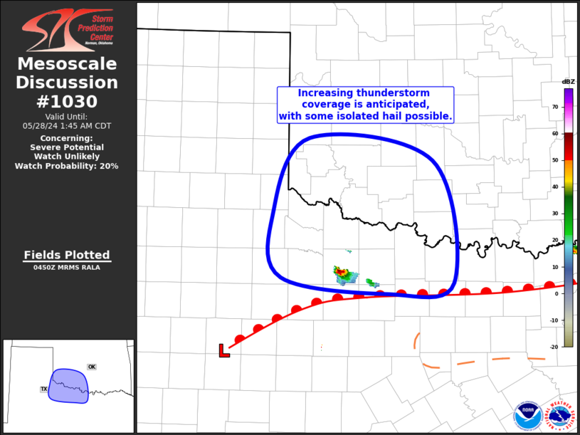
   Mesoscale Discussion 1030
   NWS Storm Prediction Center Norman OK
   1152 PM CDT Mon May 27 2024

   Areas affected...Far Northwest TX...Southwest OK

   Concerning...Severe potential...Watch unlikely

   Valid 280452Z - 280645Z

   Probability of Watch Issuance...20 percent

   SUMMARY...Increasing thunderstorm coverage, with an attendant threat
   for large hail, is anticipated across far northwest Texas and
   southwest Oklahoma over the next few hours. Overall severe coverage
   is uncertain, but convective trends will be monitored for possible
   watch issuance.

   DISCUSSION...Recent surface analysis places a low about 40 miles
   east of BGS, with a warm front extending east-northeastward from
   this low across north Texas and into the Arklatex. Modest warm-air
   advection across this boundary likely contributed to the development
   of the thunderstorm ongoing over Baylor County. The core of the
   low-level jet is expected to remain west of the region, but a
   general strengthening of the jet will allow its eastern periphery to
   interact with this frontal zone, likely contributing to additional
   storm development via warm-air advection. Steep mid-level lapse
   rates remain in place over the region, with mesoanalysis estimating
   8 to 8.5 deg C per km from 700 to 500 mb. Moderate westerly flow
   aloft will persist as well, contributing to 0-6 km bulk shear from
   40 to 50 kt. General expectation is for increasing storm coverage
   over the next hour or two, with some updrafts becoming strong enough
   to produce isolated large hail.

   ..Mosier/Smith.. 05/28/2024

   ...Please see www.spc.noaa.gov for graphic product...

   ATTN...WFO...FWD...OUN...SJT...LUB...

   LAT...LON   33470010 34240022 35209968 34929785 33409755 33289853
               33470010
|
|
Top/All Mesoscale Discussions/Forecast Products/Home
|
|


 @NWSSPC