|
| Mesoscale Discussion 1031 |
|
< Previous MD Next MD >
|
|
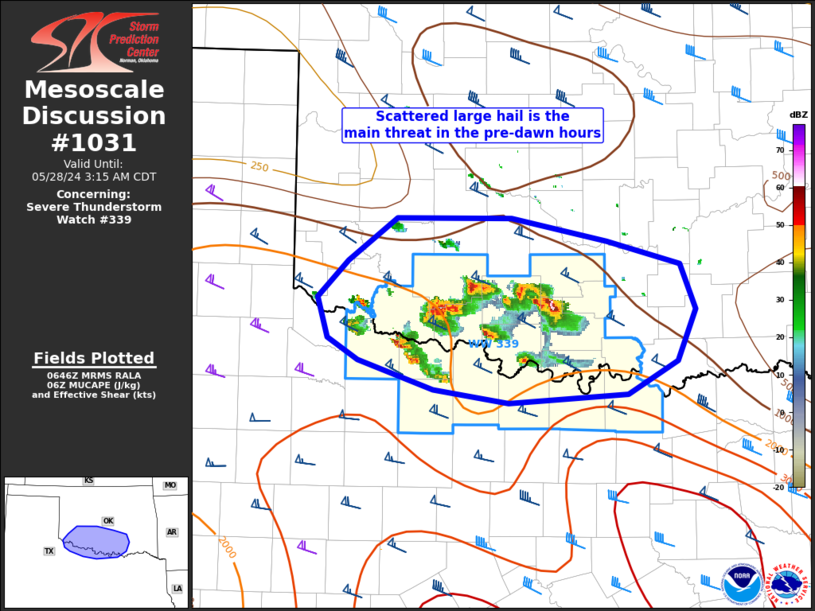
   Mesoscale Discussion 1031
   NWS Storm Prediction Center Norman OK
   0149 AM CDT Tue May 28 2024

   Areas affected...the Red River Valley of OK/TX

   Concerning...Severe Thunderstorm Watch 339...

   Valid 280649Z - 280815Z

   The severe weather threat for Severe Thunderstorm Watch 339
   continues.

   SUMMARY...Scattered large hail from several right and left-splitting
   supercells will be the primary threat through the pre-dawn hours.
   Later clustering will probably be necessary for an appreciable
   severe wind threat.

   DISCUSSION...Several right and left-splits have been noted over the
   past hour, mainly across southwest and south-central OK into far
   western north TX. Recent HRRR/RRFS runs remain completely off with
   the early morning initiation of this activity. The 00Z ECMWF appears
   to have adequately handled the ongoing evolution, with the 00Z
   NAM-NEST and NSSL-ARW too slow but with the general idea of
   low-level warm-advection driven storms persisting. With increasingly
   large MUCAPE to the south of this activity, regenerative cells will
   probably continue for the next few hours along the east periphery of
   the low-level jet centered on west TX. Hail magnitudes should
   occasionally peak around 2 inches per recent MESH estimates.

   Farther north and northeast, from west-central to southeast OK, a
   band of ACCAS is evident in radar/satellite imagery. Forecast
   soundings suggest further low-level moistening may aid in this
   activity deepening during the next few hours. But with weaker
   MUCAPE, the severe hail threat here should be more marginal.

   ..Grams.. 05/28/2024

   ...Please see www.spc.noaa.gov for graphic product...

   ATTN...WFO...FWD...OUN...

   LAT...LON   34169966 34509976 34809946 35149898 35159785 34969691
               34779619 34399603 33989622 33709671 33649788 33749861
               33989936 34169966
|
|
Top/All Mesoscale Discussions/Forecast Products/Home
|
|


 @NWSSPC