Note:
The expiration time in the watch graphic is amended if the watch is
replaced, cancelled or extended.
Note:
Note:
The expiration time in the watch graphic is amended if the watch is
replaced, cancelled or extended.
Note: Click for
Watch Status Reports.
SEL9
URGENT - IMMEDIATE BROADCAST REQUESTED
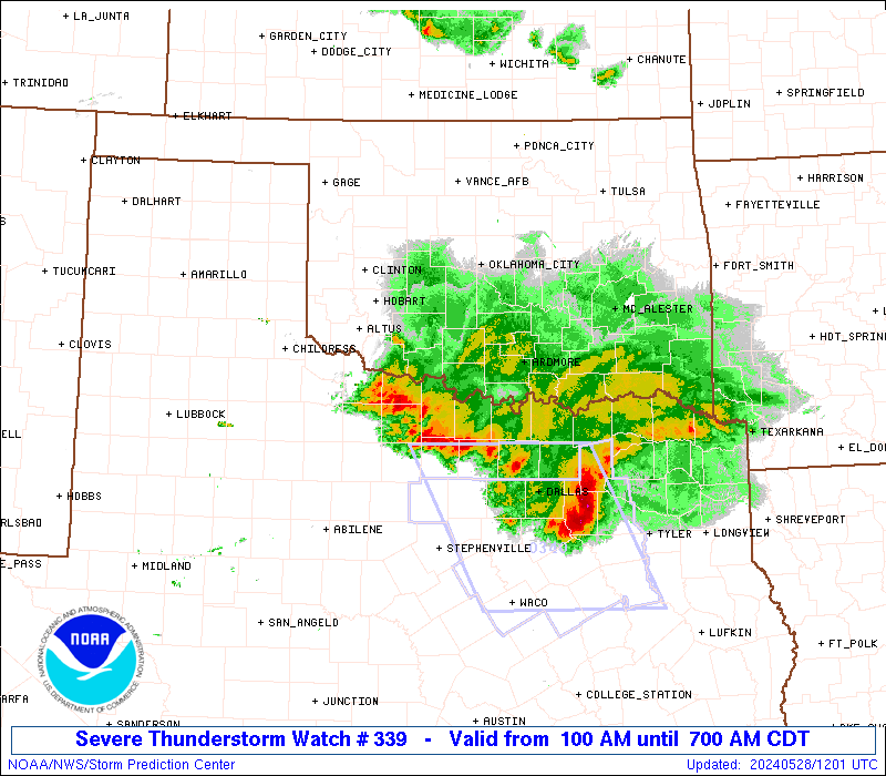
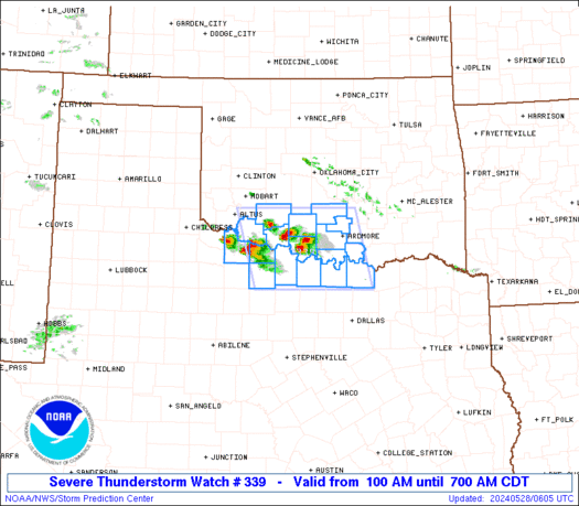
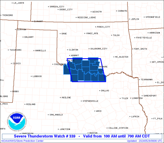
Severe Thunderstorm Watch Number 339
NWS Storm Prediction Center Norman OK
100 AM CDT Tue May 28 2024
The NWS Storm Prediction Center has issued a
* Severe Thunderstorm Watch for portions of
Southern Oklahoma
Far north Texas
* Effective this Tuesday morning from 100 AM until 700 AM CDT.
* Primary threats include...
Scattered large hail and isolated very large hail events to 2
inches in diameter possible
Isolated damaging wind gusts to 70 mph possible
SUMMARY...Elevated storms, some with supercell structure, are likely
to persist overnight over southern Oklahoma and adjacent north
Texas. Large hail of 1-2 inches in diameter will be the main threat
initially, while there could be some increase in the damaging-wind
threat closer to sunrise.
The severe thunderstorm watch area is approximately along and 70
statute miles east and west of a line from 25 miles east northeast
of Fort Sill OK to 60 miles west southwest of Sherman TX. For a
complete depiction of the watch see the associated watch outline
update (WOUS64 KWNS WOU9).
PRECAUTIONARY/PREPAREDNESS ACTIONS...
REMEMBER...A Severe Thunderstorm Watch means conditions are
favorable for severe thunderstorms in and close to the watch area.
Persons in these areas should be on the lookout for threatening
weather conditions and listen for later statements and possible
warnings. Severe thunderstorms can and occasionally do produce
tornadoes.
&&
AVIATION...A few severe thunderstorms with hail surface and aloft to
2 inches. Extreme turbulence and surface wind gusts to 60 knots. A
few cumulonimbi with maximum tops to 550. Mean storm motion vector
30020.
...Thompson
   SEL9

   URGENT - IMMEDIATE BROADCAST REQUESTED
   Severe Thunderstorm Watch Number 339
   NWS Storm Prediction Center Norman OK
   100 AM CDT Tue May 28 2024

   The NWS Storm Prediction Center has issued a

   * Severe Thunderstorm Watch for portions of
     Southern Oklahoma
     Far north Texas

   * Effective this Tuesday morning from 100 AM until 700 AM CDT.

   * Primary threats include...
     Scattered large hail and isolated very large hail events to 2
       inches in diameter possible
     Isolated damaging wind gusts to 70 mph possible

   SUMMARY...Elevated storms, some with supercell structure, are likely
   to persist overnight over southern Oklahoma and adjacent north
   Texas.  Large hail of 1-2 inches in diameter will be the main threat
   initially, while there could be some increase in the damaging-wind
   threat closer to sunrise.

   The severe thunderstorm watch area is approximately along and 70
   statute miles east and west of a line from 25 miles east northeast
   of Fort Sill OK to 60 miles west southwest of Sherman TX. For a
   complete depiction of the watch see the associated watch outline
   update (WOUS64 KWNS WOU9).

   PRECAUTIONARY/PREPAREDNESS ACTIONS...

   REMEMBER...A Severe Thunderstorm Watch means conditions are
   favorable for severe thunderstorms in and close to the watch area.
   Persons in these areas should be on the lookout for threatening
   weather conditions and listen for later statements and possible
   warnings. Severe thunderstorms can and occasionally do produce
   tornadoes.

   &&

   AVIATION...A few severe thunderstorms with hail surface and aloft to
   2 inches. Extreme turbulence and surface wind gusts to 60 knots. A
   few cumulonimbi with maximum tops to 550. Mean storm motion vector
   30020.

   ...Thompson
 Note:
The Aviation Watch (SAW) product is an approximation to the watch area.
The actual watch is depicted by the shaded areas.
Note:
The Aviation Watch (SAW) product is an approximation to the watch area.
The actual watch is depicted by the shaded areas.
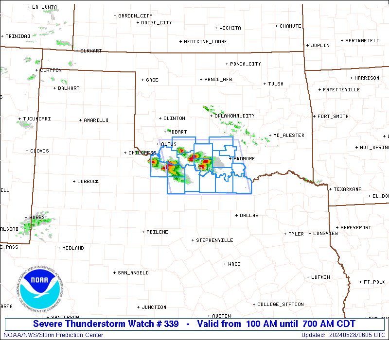
   SAW9
   WW 339 SEVERE TSTM OK TX 280600Z - 281200Z
   AXIS..70 STATUTE MILES EAST AND WEST OF LINE..
   25ENE FSI/FORT SILL OK/ - 60WSW GYI/SHERMAN TX/
   ..AVIATION COORDS.. 60NM E/W /39SSW OKC - 43NW TTT/
   HAIL SURFACE AND ALOFT..2 INCHES. WIND GUSTS..60 KNOTS.
   MAX TOPS TO 550. MEAN STORM MOTION VECTOR 30020.

   LAT...LON 34789676 33389642 33389884 34789923

   THIS IS AN APPROXIMATION TO THE WATCH AREA.  FOR A
   COMPLETE DEPICTION OF THE WATCH SEE WOUS64 KWNS
   FOR WOU9.
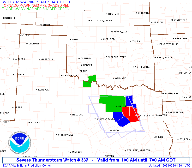
Watch 339 Status Report Messages:
STATUS REPORT #7 ON WW 339
VALID 281130Z - 281200Z
SEVERE WEATHER THREAT CONTINUES RIGHT OF A LINE FROM 10 NNE FSI
TO 45 WSW ADM TO 20 SE GYI.
WW 339 IS SCHEDULED TO EXPIRE AT 281200Z.
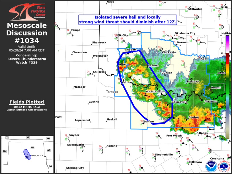
FOR ADDITIONAL INFORMATION SEE MESOSCALE DISCUSSION 1034.
..GRAMS..05/28/24
ATTN...WFO...OUN...FWD...
&&
STATUS REPORT FOR WS 339
SEVERE WEATHER THREAT CONTINUES FOR THE FOLLOWING AREAS
OKC031-033-075-141-281200-
OK
. OKLAHOMA COUNTIES INCLUDED ARE
COMANCHE COTTON KIOWA
TILLMAN
$$
TXC009-077-085-097-121-181-237-337-485-487-497-503-281200-
TX
. TEXAS COUNTIES INCLUDED ARE
ARCHER CLAY COLLIN
COOKE DENTON GRAYSON
JACK MONTAGUE WICHITA
WILBARGER WISE YOUNG
$$
THE WATCH STATUS MESSAGE IS FOR GUIDANCE PURPOSES ONLY. PLEASE
REFER TO WATCH COUNTY NOTIFICATION STATEMENTS FOR OFFICIAL
INFORMATION ON COUNTIES...INDEPENDENT CITIES AND MARINE ZONES
CLEARED FROM SEVERE THUNDERSTORM AND TORNADO WATCHES.
$$
STATUS REPORT #6 ON WW 339
VALID 281040Z - 281140Z
SEVERE WEATHER THREAT CONTINUES RIGHT OF A LINE FROM 25 S CHK TO
15 W ADM TO 10 WNW DUA.
FOR ADDITIONAL INFORMATION SEE MESOSCALE DISCUSSION 1033.
..GRAMS..05/28/24
ATTN...WFO...OUN...FWD...
&&
STATUS REPORT FOR WS 339
SEVERE WEATHER THREAT CONTINUES FOR THE FOLLOWING AREAS
OKC015-019-031-033-067-075-085-095-137-141-281140-
OK
. OKLAHOMA COUNTIES INCLUDED ARE
CADDO CARTER COMANCHE
COTTON JEFFERSON KIOWA
LOVE MARSHALL STEPHENS
TILLMAN
$$
TXC009-077-085-097-121-181-237-337-485-487-497-503-281140-
TX
. TEXAS COUNTIES INCLUDED ARE
ARCHER CLAY COLLIN
COOKE DENTON GRAYSON
JACK MONTAGUE WICHITA
WILBARGER WISE YOUNG
$$
THE WATCH STATUS MESSAGE IS FOR GUIDANCE PURPOSES ONLY. PLEASE
REFER TO WATCH COUNTY NOTIFICATION STATEMENTS FOR OFFICIAL
INFORMATION ON COUNTIES...INDEPENDENT CITIES AND MARINE ZONES
CLEARED FROM SEVERE THUNDERSTORM AND TORNADO WATCHES.
$$
STATUS REPORT #5 ON WW 339
VALID 281040Z - 281140Z
SEVERE WEATHER THREAT CONTINUES RIGHT OF A LINE FROM 25 S CHK TO
15 W ADM TO 10 WNW DUA.
FOR ADDITIONAL INFORMATION SEE MESOSCALE DISCUSSION 1033.
..GRAMS..05/28/24
ATTN...WFO...OUN...FWD...
&&
STATUS REPORT FOR WS 339
SEVERE WEATHER THREAT CONTINUES FOR THE FOLLOWING AREAS
OKC015-019-031-033-051-067-069-075-085-087-095-123-137-141-
281140-
OK
. OKLAHOMA COUNTIES INCLUDED ARE
CADDO CARTER COMANCHE
COTTON GRADY JEFFERSON
JOHNSTON KIOWA LOVE
MCCLAIN MARSHALL PONTOTOC
STEPHENS TILLMAN
$$
TXC009-077-085-097-121-181-237-337-485-487-497-503-281140-
TX
. TEXAS COUNTIES INCLUDED ARE
ARCHER CLAY COLLIN
COOKE DENTON GRAYSON
JACK MONTAGUE WICHITA
WILBARGER WISE YOUNG
$$
THE WATCH STATUS MESSAGE IS FOR GUIDANCE PURPOSES ONLY. PLEASE
REFER TO WATCH COUNTY NOTIFICATION STATEMENTS FOR OFFICIAL
INFORMATION ON COUNTIES...INDEPENDENT CITIES AND MARINE ZONES
CLEARED FROM SEVERE THUNDERSTORM AND TORNADO WATCHES.
$$
STATUS REPORT #4 ON WW 339
VALID 281035Z - 281140Z
SEVERE WEATHER THREAT CONTINUES RIGHT OF A LINE FROM 25 S CHK TO
15 W ADM TO 10 WNW DUA.
FOR ADDITIONAL INFORMATION SEE MESOSCALE DISCUSSION 1033.
..GRAMS..05/28/24
ATTN...WFO...OUN...FWD...
&&
STATUS REPORT FOR WS 339
SEVERE WEATHER THREAT CONTINUES FOR THE FOLLOWING AREAS
OKC015-019-031-033-051-067-069-075-085-087-095-123-137-141-
281140-
OK
. OKLAHOMA COUNTIES INCLUDED ARE
CADDO CARTER COMANCHE
COTTON GRADY JEFFERSON
JOHNSTON KIOWA LOVE
MCCLAIN MARSHALL PONTOTOC
STEPHENS TILLMAN
$$
TXC009-077-085-097-121-181-237-337-485-487-497-503-281140-
TX
. TEXAS COUNTIES INCLUDED ARE
ARCHER CLAY COLLIN
COOKE DENTON GRAYSON
JACK MONTAGUE WICHITA
WILBARGER WISE YOUNG
$$
THE WATCH STATUS MESSAGE IS FOR GUIDANCE PURPOSES ONLY. PLEASE
REFER TO WATCH COUNTY NOTIFICATION STATEMENTS FOR OFFICIAL
INFORMATION ON COUNTIES...INDEPENDENT CITIES AND MARINE ZONES
CLEARED FROM SEVERE THUNDERSTORM AND TORNADO WATCHES.
$$
STATUS REPORT #3 ON WW 339
VALID 280930Z - 281040Z
THE SEVERE WEATHER THREAT CONTINUES ACROSS THE ENTIRE WATCH AREA.
FOR ADDITIONAL INFORMATION SEE MESOSCALE DISCUSSION 1032.
..GRAMS..05/28/24
ATTN...WFO...OUN...FWD...
&&
STATUS REPORT FOR WS 339
SEVERE WEATHER THREAT CONTINUES FOR THE FOLLOWING AREAS
OKC015-019-031-033-049-051-067-069-075-085-087-095-099-123-137-
141-281040-
OK
. OKLAHOMA COUNTIES INCLUDED ARE
CADDO CARTER COMANCHE
COTTON GARVIN GRADY
JEFFERSON JOHNSTON KIOWA
LOVE MCCLAIN MARSHALL
MURRAY PONTOTOC STEPHENS
TILLMAN
$$
TXC009-077-085-097-121-181-237-337-485-487-497-503-281040-
TX
. TEXAS COUNTIES INCLUDED ARE
ARCHER CLAY COLLIN
COOKE DENTON GRAYSON
JACK MONTAGUE WICHITA
WILBARGER WISE YOUNG
$$
THE WATCH STATUS MESSAGE IS FOR GUIDANCE PURPOSES ONLY. PLEASE
REFER TO WATCH COUNTY NOTIFICATION STATEMENTS FOR OFFICIAL
INFORMATION ON COUNTIES...INDEPENDENT CITIES AND MARINE ZONES
CLEARED FROM SEVERE THUNDERSTORM AND TORNADO WATCHES.
$$
STATUS REPORT #2 ON WW 339
VALID 280830Z - 280940Z
THE SEVERE WEATHER THREAT CONTINUES ACROSS THE ENTIRE WATCH AREA.
FOR ADDITIONAL INFORMATION SEE MESOSCALE DISCUSSION 1032.
..GRAMS..05/28/24
ATTN...WFO...OUN...FWD...
&&
STATUS REPORT FOR WS 339
SEVERE WEATHER THREAT CONTINUES FOR THE FOLLOWING AREAS
OKC015-019-031-033-049-051-067-069-075-085-087-095-099-123-137-
141-280940-
OK
. OKLAHOMA COUNTIES INCLUDED ARE
CADDO CARTER COMANCHE
COTTON GARVIN GRADY
JEFFERSON JOHNSTON KIOWA
LOVE MCCLAIN MARSHALL
MURRAY PONTOTOC STEPHENS
TILLMAN
$$
TXC009-077-085-097-121-181-237-337-485-487-497-503-280940-
TX
. TEXAS COUNTIES INCLUDED ARE
ARCHER CLAY COLLIN
COOKE DENTON GRAYSON
JACK MONTAGUE WICHITA
WILBARGER WISE YOUNG
$$
THE WATCH STATUS MESSAGE IS FOR GUIDANCE PURPOSES ONLY. PLEASE
REFER TO WATCH COUNTY NOTIFICATION STATEMENTS FOR OFFICIAL
INFORMATION ON COUNTIES...INDEPENDENT CITIES AND MARINE ZONES
CLEARED FROM SEVERE THUNDERSTORM AND TORNADO WATCHES.
$$
STATUS REPORT #1 ON WW 339
VALID 280750Z - 280840Z
THE SEVERE WEATHER THREAT CONTINUES ACROSS THE ENTIRE WATCH AREA.
FOR ADDITIONAL INFORMATION SEE MESOSCALE DISCUSSION 1031.
..GRAMS..05/28/24
ATTN...WFO...OUN...FWD...
&&
STATUS REPORT FOR WS 339
SEVERE WEATHER THREAT CONTINUES FOR THE FOLLOWING AREAS
OKC015-019-031-033-049-051-067-069-075-085-087-095-099-123-137-
141-280840-
OK
. OKLAHOMA COUNTIES INCLUDED ARE
CADDO CARTER COMANCHE
COTTON GARVIN GRADY
JEFFERSON JOHNSTON KIOWA
LOVE MCCLAIN MARSHALL
MURRAY PONTOTOC STEPHENS
TILLMAN
$$
TXC009-077-097-181-337-485-487-280840-
TX
. TEXAS COUNTIES INCLUDED ARE
ARCHER CLAY COOKE
GRAYSON MONTAGUE WICHITA
WILBARGER
$$
THE WATCH STATUS MESSAGE IS FOR GUIDANCE PURPOSES ONLY. PLEASE
REFER TO WATCH COUNTY NOTIFICATION STATEMENTS FOR OFFICIAL
INFORMATION ON COUNTIES...INDEPENDENT CITIES AND MARINE ZONES
CLEARED FROM SEVERE THUNDERSTORM AND TORNADO WATCHES.
$$
Note:
Click for Complete Product Text.
Tornadoes
Probability of 2 or more tornadoes
|
Low (10%)
|
Probability of 1 or more strong (EF2-EF5) tornadoes
|
Low (<2%)
|
Wind
Probability of 10 or more severe wind events
|
Mod (30%)
|
Probability of 1 or more wind events > 65 knots
|
Low (20%)
|
Hail
Probability of 10 or more severe hail events
|
Mod (40%)
|
Probability of 1 or more hailstones > 2 inches
|
Mod (30%)
|
Combined Severe Hail/Wind
Probability of 6 or more combined severe hail/wind events
|
High (70%)
|
For each watch, probabilities for particular events inside the watch
(listed above in each table) are determined by the issuing forecaster.
The "Low" category contains probability values ranging from less than 2%
to 20% (EF2-EF5 tornadoes), less than 5% to 20% (all other probabilities),
"Moderate" from 30% to 60%, and "High" from 70% to greater than 95%.
High values are bolded and lighter in color to provide awareness of
an increased threat for a particular event.


 @NWSSPC