Note:
The expiration time in the watch graphic is amended if the watch is
replaced, cancelled or extended.
Note:
Note:
The expiration time in the watch graphic is amended if the watch is
replaced, cancelled or extended.
Note: Click for
Watch Status Reports.
SEL0
URGENT - IMMEDIATE BROADCAST REQUESTED
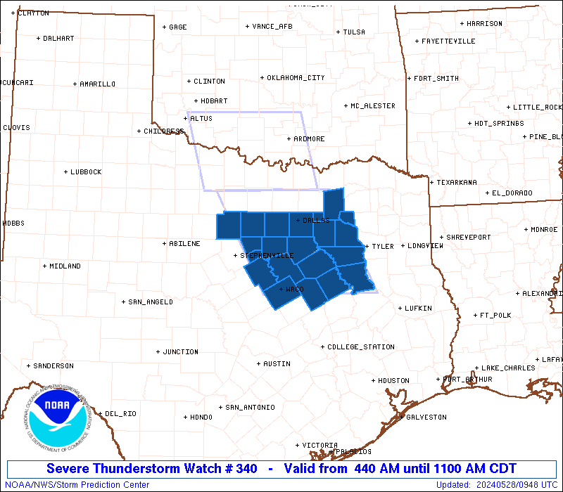
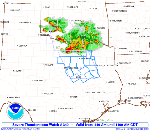
Severe Thunderstorm Watch Number 340
NWS Storm Prediction Center Norman OK
440 AM CDT Tue May 28 2024
The NWS Storm Prediction Center has issued a
* Severe Thunderstorm Watch for portions of
North central Texas
* Effective this Tuesday morning from 440 AM until 1100 AM CDT.
* Primary threats include...
Scattered damaging winds and isolated significant gusts to 80
mph likely
Scattered large hail and isolated very large hail events to 2
inches in diameter likely
SUMMARY...Clusters of storms, including embedded supercells, will
likely persist through at least mid morning while moving
south-southeastward toward the Dallas-Fort Worth Metroplex and areas
farther south. Swaths of damage with 60-80 mph winds will be
possible, especially on the west flank of embedded supercells.
Large hail of 1-2 inches in diameter can also be expected with the
more intense storms.
The severe thunderstorm watch area is approximately along and 70
statute miles east and west of a line from 40 miles north of Fort
Worth TX to 35 miles south of Corsicana TX. For a complete depiction
of the watch see the associated watch outline update (WOUS64 KWNS
WOU0).
PRECAUTIONARY/PREPAREDNESS ACTIONS...
REMEMBER...A Severe Thunderstorm Watch means conditions are
favorable for severe thunderstorms in and close to the watch area.
Persons in these areas should be on the lookout for threatening
weather conditions and listen for later statements and possible
warnings. Severe thunderstorms can and occasionally do produce
tornadoes.
&&
OTHER WATCH INFORMATION...CONTINUE...WW 339...
AVIATION...A few severe thunderstorms with hail surface and aloft to
2 inches. Extreme turbulence and surface wind gusts to 70 knots. A
few cumulonimbi with maximum tops to 600. Mean storm motion vector
32025.
...Thompson
   SEL0

   URGENT - IMMEDIATE BROADCAST REQUESTED
   Severe Thunderstorm Watch Number 340
   NWS Storm Prediction Center Norman OK
   440 AM CDT Tue May 28 2024

   The NWS Storm Prediction Center has issued a

   * Severe Thunderstorm Watch for portions of
     North central Texas

   * Effective this Tuesday morning from 440 AM until 1100 AM CDT.

   * Primary threats include...
     Scattered damaging winds and isolated significant gusts to 80
       mph likely
     Scattered large hail and isolated very large hail events to 2
       inches in diameter likely

   SUMMARY...Clusters of storms, including embedded supercells, will
   likely persist through at least mid morning while moving
   south-southeastward toward the Dallas-Fort Worth Metroplex and areas
   farther south.  Swaths of damage with 60-80 mph winds will be
   possible, especially on the west flank of embedded supercells.
   Large hail of 1-2 inches in diameter can also be expected with the
   more intense storms.

   The severe thunderstorm watch area is approximately along and 70
   statute miles east and west of a line from 40 miles north of Fort
   Worth TX to 35 miles south of Corsicana TX. For a complete depiction
   of the watch see the associated watch outline update (WOUS64 KWNS
   WOU0).

   PRECAUTIONARY/PREPAREDNESS ACTIONS...

   REMEMBER...A Severe Thunderstorm Watch means conditions are
   favorable for severe thunderstorms in and close to the watch area.
   Persons in these areas should be on the lookout for threatening
   weather conditions and listen for later statements and possible
   warnings. Severe thunderstorms can and occasionally do produce
   tornadoes.

   &&

   OTHER WATCH INFORMATION...CONTINUE...WW 339...

   AVIATION...A few severe thunderstorms with hail surface and aloft to
   2 inches. Extreme turbulence and surface wind gusts to 70 knots. A
   few cumulonimbi with maximum tops to 600. Mean storm motion vector
   32025.

   ...Thompson
 Note:
The Aviation Watch (SAW) product is an approximation to the watch area.
The actual watch is depicted by the shaded areas.
Note:
The Aviation Watch (SAW) product is an approximation to the watch area.
The actual watch is depicted by the shaded areas.
   SAW0
   WW 340 SEVERE TSTM TX 280940Z - 281600Z
   AXIS..70 STATUTE MILES EAST AND WEST OF LINE..
   40N FTW/FORT WORTH TX/ - 35S CRS/CORSICANA TX/
   ..AVIATION COORDS.. 60NM E/W /36NNW TTT - 45E ACT/
   HAIL SURFACE AND ALOFT..2 INCHES. WIND GUSTS..70 KNOTS.
   MAX TOPS TO 600. MEAN STORM MOTION VECTOR 32025.

   LAT...LON 33399616 31529521 31529759 33399858

   THIS IS AN APPROXIMATION TO THE WATCH AREA.  FOR A
   COMPLETE DEPICTION OF THE WATCH SEE WOUS64 KWNS
   FOR WOU0.
Watch 340 Status Report Messages:
STATUS REPORT #6 ON WW 340
VALID 281555Z - 281640Z
SEVERE WEATHER THREAT CONTINUES RIGHT OF A LINE FROM 5 E SEP TO
30 SSE FTW TO 10 N TYR.
..LEITMAN..05/28/24
ATTN...WFO...FWD...
&&
STATUS REPORT FOR WS 340
SEVERE WEATHER THREAT CONTINUES FOR THE FOLLOWING AREAS
TXC001-035-139-161-213-217-251-293-309-349-425-281640-
TX
. TEXAS COUNTIES INCLUDED ARE
ANDERSON BOSQUE ELLIS
FREESTONE HENDERSON HILL
JOHNSON LIMESTONE MCLENNAN
NAVARRO SOMERVELL
$$
THE WATCH STATUS MESSAGE IS FOR GUIDANCE PURPOSES ONLY. PLEASE
REFER TO WATCH COUNTY NOTIFICATION STATEMENTS FOR OFFICIAL
INFORMATION ON COUNTIES...INDEPENDENT CITIES AND MARINE ZONES
CLEARED FROM SEVERE THUNDERSTORM AND TORNADO WATCHES.
$$
STATUS REPORT #5 ON WW 340
VALID 281435Z - 281540Z
SEVERE WEATHER THREAT CONTINUES RIGHT OF A LINE FROM 40 NW SEP TO
20 SE DAL TO 45 SSW PRX.
..LEITMAN..05/28/24
ATTN...WFO...FWD...
&&
STATUS REPORT FOR WS 340
SEVERE WEATHER THREAT CONTINUES FOR THE FOLLOWING AREAS
TXC001-035-139-161-213-217-221-251-257-293-309-349-379-425-467-
281540-
TX
. TEXAS COUNTIES INCLUDED ARE
ANDERSON BOSQUE ELLIS
FREESTONE HENDERSON HILL
HOOD JOHNSON KAUFMAN
LIMESTONE MCLENNAN NAVARRO
RAINS SOMERVELL VAN ZANDT
$$
THE WATCH STATUS MESSAGE IS FOR GUIDANCE PURPOSES ONLY. PLEASE
REFER TO WATCH COUNTY NOTIFICATION STATEMENTS FOR OFFICIAL
INFORMATION ON COUNTIES...INDEPENDENT CITIES AND MARINE ZONES
CLEARED FROM SEVERE THUNDERSTORM AND TORNADO WATCHES.
$$
STATUS REPORT #4 ON WW 340
VALID 281325Z - 281440Z
SEVERE WEATHER THREAT CONTINUES RIGHT OF A LINE FROM 30 WNW MWL
TO 50 NNW TYR.
..LEITMAN..05/28/24
ATTN...WFO...FWD...
&&
STATUS REPORT FOR WS 340
SEVERE WEATHER THREAT CONTINUES FOR THE FOLLOWING AREAS
TXC001-035-113-139-161-213-217-221-251-257-293-309-349-363-367-
379-397-425-439-467-281440-
TX
. TEXAS COUNTIES INCLUDED ARE
ANDERSON BOSQUE DALLAS
ELLIS FREESTONE HENDERSON
HILL HOOD JOHNSON
KAUFMAN LIMESTONE MCLENNAN
NAVARRO PALO PINTO PARKER
RAINS ROCKWALL SOMERVELL
TARRANT VAN ZANDT
$$
THE WATCH STATUS MESSAGE IS FOR GUIDANCE PURPOSES ONLY. PLEASE
REFER TO WATCH COUNTY NOTIFICATION STATEMENTS FOR OFFICIAL
INFORMATION ON COUNTIES...INDEPENDENT CITIES AND MARINE ZONES
CLEARED FROM SEVERE THUNDERSTORM AND TORNADO WATCHES.
$$
STATUS REPORT #3 ON WW 340
VALID 281225Z - 281340Z
THE SEVERE WEATHER THREAT CONTINUES ACROSS THE ENTIRE WATCH AREA.
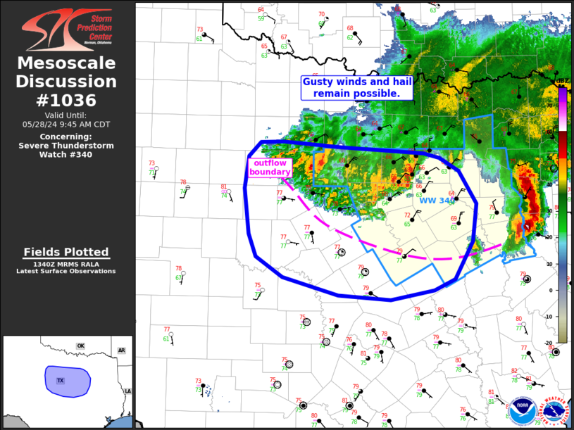
FOR ADDITIONAL INFORMATION SEE MESOSCALE DISCUSSION 1035.
..GRAMS..05/28/24
ATTN...WFO...FWD...
&&
STATUS REPORT FOR WS 340
SEVERE WEATHER THREAT CONTINUES FOR THE FOLLOWING AREAS
TXC001-035-113-139-161-213-217-221-231-251-257-293-309-349-363-
367-379-397-425-439-467-281340-
TX
. TEXAS COUNTIES INCLUDED ARE
ANDERSON BOSQUE DALLAS
ELLIS FREESTONE HENDERSON
HILL HOOD HUNT
JOHNSON KAUFMAN LIMESTONE
MCLENNAN NAVARRO PALO PINTO
PARKER RAINS ROCKWALL
SOMERVELL TARRANT VAN ZANDT
$$
THE WATCH STATUS MESSAGE IS FOR GUIDANCE PURPOSES ONLY. PLEASE
REFER TO WATCH COUNTY NOTIFICATION STATEMENTS FOR OFFICIAL
INFORMATION ON COUNTIES...INDEPENDENT CITIES AND MARINE ZONES
CLEARED FROM SEVERE THUNDERSTORM AND TORNADO WATCHES.
$$
STATUS REPORT #2 ON WW 340
VALID 281135Z - 281240Z
THE SEVERE WEATHER THREAT CONTINUES ACROSS THE ENTIRE WATCH AREA.
FOR ADDITIONAL INFORMATION SEE MESOSCALE DISCUSSION 1035.
..GRAMS..05/28/24
ATTN...WFO...FWD...
&&
STATUS REPORT FOR WS 340
SEVERE WEATHER THREAT CONTINUES FOR THE FOLLOWING AREAS
TXC001-035-113-139-161-213-217-221-231-251-257-293-309-349-363-
367-379-397-425-439-467-281240-
TX
. TEXAS COUNTIES INCLUDED ARE
ANDERSON BOSQUE DALLAS
ELLIS FREESTONE HENDERSON
HILL HOOD HUNT
JOHNSON KAUFMAN LIMESTONE
MCLENNAN NAVARRO PALO PINTO
PARKER RAINS ROCKWALL
SOMERVELL TARRANT VAN ZANDT
$$
THE WATCH STATUS MESSAGE IS FOR GUIDANCE PURPOSES ONLY. PLEASE
REFER TO WATCH COUNTY NOTIFICATION STATEMENTS FOR OFFICIAL
INFORMATION ON COUNTIES...INDEPENDENT CITIES AND MARINE ZONES
CLEARED FROM SEVERE THUNDERSTORM AND TORNADO WATCHES.
$$
STATUS REPORT #1 ON WW 340
VALID 281040Z - 281140Z
THE SEVERE WEATHER THREAT CONTINUES ACROSS THE ENTIRE WATCH AREA.
FOR ADDITIONAL INFORMATION SEE MESOSCALE DISCUSSION 1033.
..GRAMS..05/28/24
ATTN...WFO...FWD...
&&
STATUS REPORT FOR WS 340
SEVERE WEATHER THREAT CONTINUES FOR THE FOLLOWING AREAS
TXC001-035-113-139-161-213-217-221-231-251-257-293-309-349-363-
367-379-397-425-439-467-281140-
TX
. TEXAS COUNTIES INCLUDED ARE
ANDERSON BOSQUE DALLAS
ELLIS FREESTONE HENDERSON
HILL HOOD HUNT
JOHNSON KAUFMAN LIMESTONE
MCLENNAN NAVARRO PALO PINTO
PARKER RAINS ROCKWALL
SOMERVELL TARRANT VAN ZANDT
$$
THE WATCH STATUS MESSAGE IS FOR GUIDANCE PURPOSES ONLY. PLEASE
REFER TO WATCH COUNTY NOTIFICATION STATEMENTS FOR OFFICIAL
INFORMATION ON COUNTIES...INDEPENDENT CITIES AND MARINE ZONES
CLEARED FROM SEVERE THUNDERSTORM AND TORNADO WATCHES.
$$
Note:
Click for Complete Product Text.
Tornadoes
Probability of 2 or more tornadoes
|
Low (10%)
|
Probability of 1 or more strong (EF2-EF5) tornadoes
|
Low (5%)
|
Wind
Probability of 10 or more severe wind events
|
Mod (60%)
|
Probability of 1 or more wind events > 65 knots
|
Mod (60%)
|
Hail
Probability of 10 or more severe hail events
|
Mod (60%)
|
Probability of 1 or more hailstones > 2 inches
|
Mod (60%)
|
Combined Severe Hail/Wind
Probability of 6 or more combined severe hail/wind events
|
High (>95%)
|
For each watch, probabilities for particular events inside the watch
(listed above in each table) are determined by the issuing forecaster.
The "Low" category contains probability values ranging from less than 2%
to 20% (EF2-EF5 tornadoes), less than 5% to 20% (all other probabilities),
"Moderate" from 30% to 60%, and "High" from 70% to greater than 95%.
High values are bolded and lighter in color to provide awareness of
an increased threat for a particular event.


 @NWSSPC