|
| Mesoscale Discussion 1068 |
|
< Previous MD Next MD >
|

|
   Mesoscale Discussion 1068
   NWS Storm Prediction Center Norman OK
   0327 PM CDT Wed May 29 2024

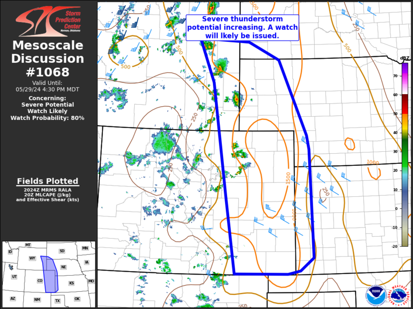
   Areas affected...southeast WY...western NE...eastern CO and far
   western KS

   Concerning...Severe potential...Watch likely

   Valid 292027Z - 292230Z

   Probability of Watch Issuance...80 percent

   SUMMARY...Isolated severe thunderstorms are expected into early
   evening. Damaging gusts and hail will be the main concerns with this
   activity. A severe thunderstorm watch is likely.

   DISCUSSION...Thunderstorms are intensifying this afternoon away from
   higher terrain over the adjacent high Plains. Southeasterly
   low-level winds around 20-30 kt have allowed dewpoints to climb into
   the upper 40s to low 50s F. Strong heating and steep midlevel lapse
   rates are further supporting MLCAPE values up to 1500 J/kg. Vertical
   shear is expected to increase with eastward extent toward evening,
   and thunderstorm clusters may become better organized with time.
   Furthermore, a deeply mixed boundary layer with inverted-v sub-cloud
   thermodynamic profiles will support strong downdrafts and
   thunderstorm gusts of 55-70 mph are expected. Additionally, very
   steep midlevel lapse rates and sufficient vertical shear and
   instability for at least briefly robust updrafts may also support
   large hail. Some potential for a couple of landspouts also will
   exist into early evening across parts of eastern CO where backed
   low-level winds are present in an area of low-level convergence near
   a surface low/trough.

   A severe thunderstorm watch is likely for portions of the MCD area.

   ..Leitman/Guyer.. 05/29/2024

   ...Please see www.spc.noaa.gov for graphic product...

   ATTN...WFO...LBF...DDC...UNR...GLD...PUB...BOU...CYS...

   LAT...LON   43560553 43470370 42970257 40860159 40480150 37450140
               37100186 37000231 37010349 37020417 39180451 42330499
               43560553
|
|
Top/All Mesoscale Discussions/Forecast Products/Home
|
|


