|
| Mesoscale Discussion 1069 |
|
< Previous MD Next MD >
|
|
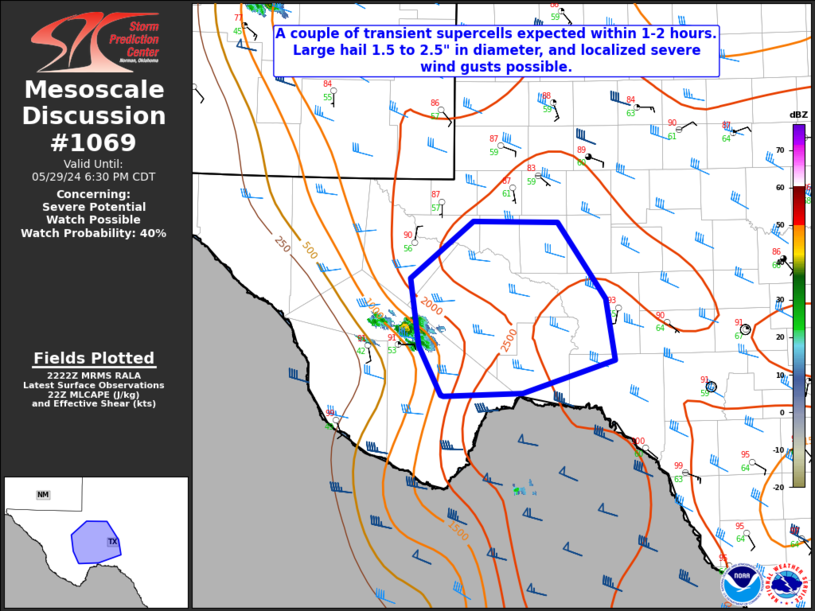
   Mesoscale Discussion 1069
   NWS Storm Prediction Center Norman OK
   0524 PM CDT Wed May 29 2024

   Areas affected...Portions of the Permian Basin and Stockton Plateua

   Concerning...Severe potential...Watch possible

   Valid 292224Z - 292330Z

   Probability of Watch Issuance...40 percent

   SUMMARY...A couple of transient supercells may develop within the
   next 1-2 hours across portions of the Stockton Plateau and Permian
   basin. Large hail up to 1.5 to 2.5" in diameter, and perhaps
   localized severe wind gusts may accompany these thunderstorms.

   DISCUSSION...Latest radar imagery from KMAF shows continued attempts
   of deep moist convection over the Davis Mountains via orographic
   ascent and easterly upslope flow. Surface observations across this
   region, combined with modified RAP forecast soundings, suggest
   localized CINH has eroded here, with very steep mid level lapse
   rates in place. Large CAPE within the hail growth zone, combined
   with effective deep layer shear magnitudes of 30-35 kt, will promote
   some updraft organization. However, more broader scale forcing
   mechanisms will limit the overall coverage of the severe threat.

   ..Barnes/Hart.. 05/29/2024

   ...Please see www.spc.noaa.gov for graphic product...

   ATTN...WFO...EWX...SJT...MAF...

   LAT...LON   29890320 30360344 31030355 31580283 31570187 30820134
               30220124 29910227 29880317 29890320
|
|
Top/All Mesoscale Discussions/Forecast Products/Home
|
|


 @NWSSPC