|
| Mesoscale Discussion 1073 |
|
< Previous MD Next MD >
|
|
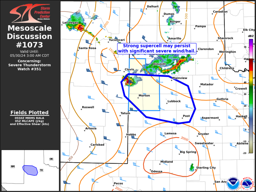
   Mesoscale Discussion 1073
   NWS Storm Prediction Center Norman OK
   1253 AM CDT Thu May 30 2024

   Areas affected...TX South Plains

   Concerning...Severe Thunderstorm Watch 351...

   Valid 300553Z - 300800Z

   The severe weather threat for Severe Thunderstorm Watch 351
   continues.

   SUMMARY...Slow-moving, but potentially long-lived supercell should
   persist across a portion of the Texas South Plains as it likely
   tracks east-southeast through the pre-dawn hours. A narrow swath of
   occasional significant severe wind and hail is possible.

   DISCUSSION...A slow-moving supercell centered on northeast Roosevelt
   County, NM appears to have finally be turning to the east-southeast
   from its initial south-southeast track. This storm has a history of
   reported very large hail to 2.5 inches at Cannon AFB last hour. West
   TX Mesonet obs confirm a plume of low to mid 60s surface dew points
   immediately ahead of this supercell across the TX South Plains. With
   larger buoyancy and a stronger low-level jet relative to last
   night's intense supercell that similarly tracked across the region,
   it is plausible that this supercell may become a long-lived one as
   it moves toward the I-27/US-87 corridor. A narrow swath of
   significant severe hail is possible early, with an increasing risk
   for significant severe wind as supercell bowing structures
   potentially develop.

   ..Grams/Thompson.. 05/30/2024

   ...Please see www.spc.noaa.gov for graphic product...

   ATTN...WFO...LUB...ABQ...

   LAT...LON   34340307 34280179 34030118 33430097 33090114 33050150
               33220249 33760317 34120328 34340307
|
|
Top/All Mesoscale Discussions/Forecast Products/Home
|
|


 @NWSSPC