Note:
The expiration time in the watch graphic is amended if the watch is
replaced, cancelled or extended.
Note:
Note:
The expiration time in the watch graphic is amended if the watch is
replaced, cancelled or extended.
Note: Click for
Watch Status Reports.
SEL1
URGENT - IMMEDIATE BROADCAST REQUESTED
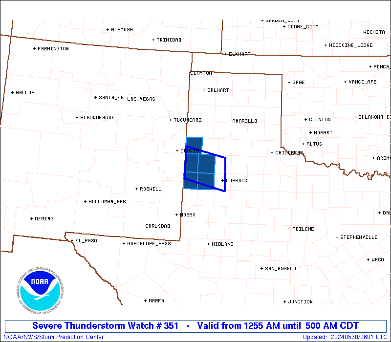
Severe Thunderstorm Watch Number 351
NWS Storm Prediction Center Norman OK
1255 AM CDT Thu May 30 2024
The NWS Storm Prediction Center has issued a
* Severe Thunderstorm Watch for portions of
The Texas South Plains
* Effective this Thursday morning from 1255 AM until 500 AM CDT.
* Primary threats include...
Isolated significant damaging wind gusts to 75 mph possible
Isolated very large hail events to 2 inches in diameter possible
SUMMARY...A long-lived supercell may persist for a few more hours
while moving slowly southeastward into Texas from New Mexico. The
storm environment suggests the storm could maintain intensity, with
the potential to produce isolated large hail to 2 inches in diameter
and severe gusts up to 75 mph.
The severe thunderstorm watch area is approximately along and 30
statute miles north and south of a line from 75 miles west northwest
of Lubbock TX to 10 miles north northeast of Lubbock TX. For a
complete depiction of the watch see the associated watch outline
update (WOUS64 KWNS WOU1).
PRECAUTIONARY/PREPAREDNESS ACTIONS...
REMEMBER...A Severe Thunderstorm Watch means conditions are
favorable for severe thunderstorms in and close to the watch area.
Persons in these areas should be on the lookout for threatening
weather conditions and listen for later statements and possible
warnings. Severe thunderstorms can and occasionally do produce
tornadoes.
&&
AVIATION...A few severe thunderstorms with hail surface and aloft to
2 inches. Extreme turbulence and surface wind gusts to 65 knots. A
few cumulonimbi with maximum tops to 550. Mean storm motion vector
31015.
...Thompson

   SEL1

   URGENT - IMMEDIATE BROADCAST REQUESTED
   Severe Thunderstorm Watch Number 351
   NWS Storm Prediction Center Norman OK
   1255 AM CDT Thu May 30 2024

   The NWS Storm Prediction Center has issued a

   * Severe Thunderstorm Watch for portions of
     The Texas South Plains

   * Effective this Thursday morning from 1255 AM until 500 AM CDT.

   * Primary threats include...
     Isolated significant damaging wind gusts to 75 mph possible
     Isolated very large hail events to 2 inches in diameter possible

   SUMMARY...A long-lived supercell may persist for a few more hours
   while moving slowly southeastward into Texas from New Mexico.  The
   storm environment suggests the storm could maintain intensity, with
   the potential to produce isolated large hail to 2 inches in diameter
   and severe gusts up to 75 mph.

   The severe thunderstorm watch area is approximately along and 30
   statute miles north and south of a line from 75 miles west northwest
   of Lubbock TX to 10 miles north northeast of Lubbock TX. For a
   complete depiction of the watch see the associated watch outline
   update (WOUS64 KWNS WOU1).

   PRECAUTIONARY/PREPAREDNESS ACTIONS...

   REMEMBER...A Severe Thunderstorm Watch means conditions are
   favorable for severe thunderstorms in and close to the watch area.
   Persons in these areas should be on the lookout for threatening
   weather conditions and listen for later statements and possible
   warnings. Severe thunderstorms can and occasionally do produce
   tornadoes.

   &&

   AVIATION...A few severe thunderstorms with hail surface and aloft to
   2 inches. Extreme turbulence and surface wind gusts to 65 knots. A
   few cumulonimbi with maximum tops to 550. Mean storm motion vector
   31015.

   ...Thompson
 Note:
The Aviation Watch (SAW) product is an approximation to the watch area.
The actual watch is depicted by the shaded areas.
Note:
The Aviation Watch (SAW) product is an approximation to the watch area.
The actual watch is depicted by the shaded areas.
   SAW1
   WW 351 SEVERE TSTM TX 300555Z - 301000Z
   AXIS..30 STATUTE MILES NORTH AND SOUTH OF LINE..
   75WNW LBB/LUBBOCK TX/ - 10NNE LBB/LUBBOCK TX/
   ..AVIATION COORDS.. 25NM N/S /27SSW TXO - 10NE LBB/
   HAIL SURFACE AND ALOFT..2 INCHES. WIND GUSTS..65 KNOTS.
   MAX TOPS TO 550. MEAN STORM MOTION VECTOR 31015.

   LAT...LON 34500303 34240175 33370175 33650303

   THIS IS AN APPROXIMATION TO THE WATCH AREA.  FOR A
   COMPLETE DEPICTION OF THE WATCH SEE WOUS64 KWNS
   FOR WOU1.
Watch 351 Status Report Messages:
STATUS REPORT #3 ON WW 351
VALID 300830Z - 300940Z
SEVERE WEATHER THREAT CONTINUES RIGHT OF A LINE FROM 15 SSE LBB
TO 40 W LBB TO 40 WNW PVW.
..GRAMS..05/30/24
ATTN...WFO...LUB...
&&
STATUS REPORT FOR WS 351
SEVERE WEATHER THREAT CONTINUES FOR THE FOLLOWING AREAS
TXC279-300940-
TX
. TEXAS COUNTIES INCLUDED ARE
LAMB
$$
THE WATCH STATUS MESSAGE IS FOR GUIDANCE PURPOSES ONLY. PLEASE
REFER TO WATCH COUNTY NOTIFICATION STATEMENTS FOR OFFICIAL
INFORMATION ON COUNTIES...INDEPENDENT CITIES AND MARINE ZONES
CLEARED FROM SEVERE THUNDERSTORM AND TORNADO WATCHES.
$$
STATUS REPORT #2 ON WW 351
VALID 300730Z - 300840Z
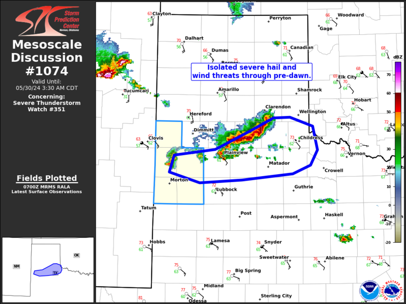
THE SEVERE WEATHER THREAT CONTINUES ACROSS THE ENTIRE WATCH AREA.
FOR ADDITIONAL INFORMATION SEE MESOSCALE DISCUSSION 1074.
..GRAMS..05/30/24
ATTN...WFO...LUB...
&&
STATUS REPORT FOR WS 351
SEVERE WEATHER THREAT CONTINUES FOR THE FOLLOWING AREAS
TXC017-079-219-279-369-300840-
TX
. TEXAS COUNTIES INCLUDED ARE
BAILEY COCHRAN HOCKLEY
LAMB PARMER
$$
THE WATCH STATUS MESSAGE IS FOR GUIDANCE PURPOSES ONLY. PLEASE
REFER TO WATCH COUNTY NOTIFICATION STATEMENTS FOR OFFICIAL
INFORMATION ON COUNTIES...INDEPENDENT CITIES AND MARINE ZONES
CLEARED FROM SEVERE THUNDERSTORM AND TORNADO WATCHES.
$$
STATUS REPORT #1 ON WW 351
VALID 300630Z - 300740Z
THE SEVERE WEATHER THREAT CONTINUES ACROSS THE ENTIRE WATCH AREA.
FOR ADDITIONAL INFORMATION SEE MESOSCALE DISCUSSION 1073.
..GRAMS..05/30/24
ATTN...WFO...LUB...
&&
STATUS REPORT FOR WS 351
SEVERE WEATHER THREAT CONTINUES FOR THE FOLLOWING AREAS
TXC017-079-219-279-369-300740-
TX
. TEXAS COUNTIES INCLUDED ARE
BAILEY COCHRAN HOCKLEY
LAMB PARMER
$$
THE WATCH STATUS MESSAGE IS FOR GUIDANCE PURPOSES ONLY. PLEASE
REFER TO WATCH COUNTY NOTIFICATION STATEMENTS FOR OFFICIAL
INFORMATION ON COUNTIES...INDEPENDENT CITIES AND MARINE ZONES
CLEARED FROM SEVERE THUNDERSTORM AND TORNADO WATCHES.
$$
Note:
Click for Complete Product Text.
Tornadoes
Probability of 2 or more tornadoes
|
Low (10%)
|
Probability of 1 or more strong (EF2-EF5) tornadoes
|
Low (<2%)
|
Wind
Probability of 10 or more severe wind events
|
Mod (30%)
|
Probability of 1 or more wind events > 65 knots
|
Mod (30%)
|
Hail
Probability of 10 or more severe hail events
|
Mod (30%)
|
Probability of 1 or more hailstones > 2 inches
|
Mod (30%)
|
Combined Severe Hail/Wind
Probability of 6 or more combined severe hail/wind events
|
Mod (60%)
|
For each watch, probabilities for particular events inside the watch
(listed above in each table) are determined by the issuing forecaster.
The "Low" category contains probability values ranging from less than 2%
to 20% (EF2-EF5 tornadoes), less than 5% to 20% (all other probabilities),
"Moderate" from 30% to 60%, and "High" from 70% to greater than 95%.
High values are bolded and lighter in color to provide awareness of
an increased threat for a particular event.


 @NWSSPC