|
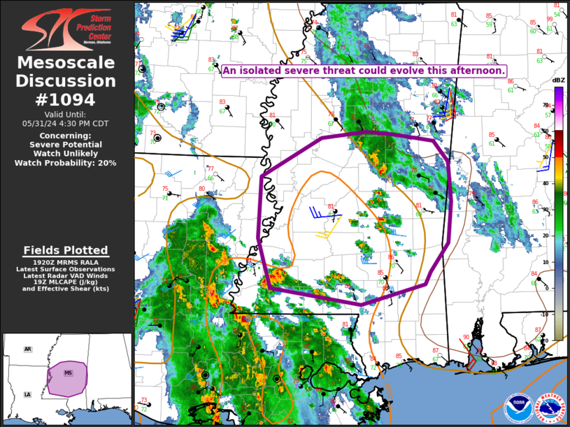
| Mesoscale Discussion 1094 |
|
< Previous MD Next MD >
|
|
   Mesoscale Discussion 1094
   NWS Storm Prediction Center Norman OK
   0223 PM CDT Fri May 31 2024

   Areas affected...Northeast LA into central/southern MS

   Concerning...Severe potential...Watch unlikely

   Valid 311923Z - 312130Z

   Probability of Watch Issuance...20 percent

   SUMMARY...An isolated severe-thunderstorm threat could evolve this
   afternoon.

   DISCUSSION...Several small, weakly rotating cells have developed
   this afternoon across east-central MS, within a weakly capped and
   moderately buoyant (MLCAPE of near or above 1000 J/kg) environment.
   While deep-layer flow is not particularly strong, vertical shear is
   somewhat enhanced by backed low-level flow near a retreating diffuse
   baroclinic zone, and a transient supercell or two cannot be ruled
   out, with a threat of locally damaging wind and possibly a brief
   tornado.

   Farther southwest, deep-layer shear is somewhat weaker south of the
   warm front, but MLCAPE increasing above 1500 J/kg and increasingly
   warm/moist surface conditions could support locally damaging winds
   as convection spreads northeastward out of Louisiana through the
   afternoon.

   ..Dean/Smith.. 05/31/2024

   ...Please see www.spc.noaa.gov for graphic product...

   ATTN...WFO...BMX...MOB...JAN...LIX...

   LAT...LON   33218859 32948836 32438833 31918838 31538864 31388872
               31118968 31339105 31979123 32769120 33269028 33348962
               33318922 33218859
|
|
Top/All Mesoscale Discussions/Forecast Products/Home
|
|


 @NWSSPC