|
| Mesoscale Discussion 1099 |
|
< Previous MD Next MD >
|
|
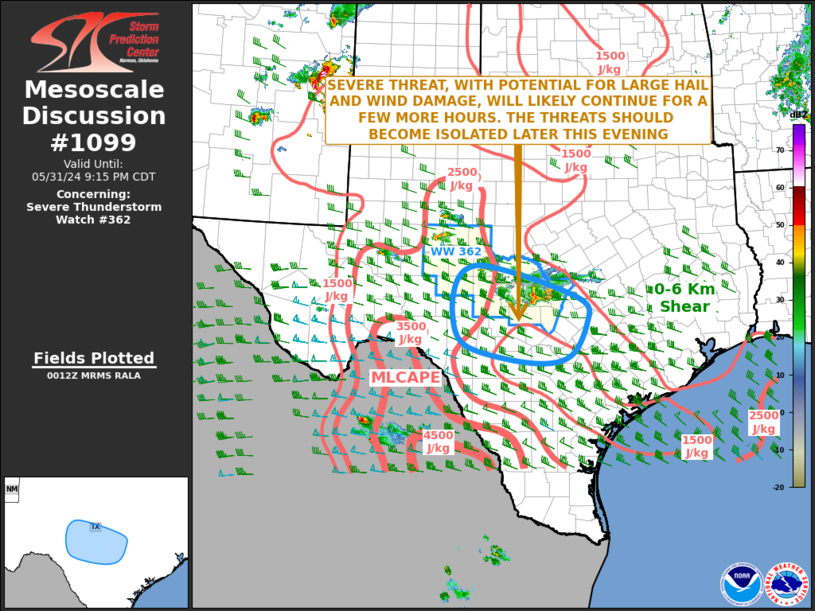
   Mesoscale Discussion 1099
   NWS Storm Prediction Center Norman OK
   0715 PM CDT Fri May 31 2024

   Areas affected...Central Texas

   Concerning...Severe Thunderstorm Watch 362...

   Valid 010015Z - 010215Z

   The severe weather threat for Severe Thunderstorm Watch 362
   continues.

   SUMMARY...A severe threat, with potential for large hail and severe
   wind gusts, will likely continue over the next couple of hours.
   Uncertainty exists concerning the persistence of the severe threat
   through the mid to late evening. If the threat can continue as the
   storms move towards the southern edge of watch 362, a new watch or
   extension in area could be needed.

   DISCUSSION...The latest hi-resolution radar imagery from New
   Braunfels, TX shows a small cluster of strong to severe storms
   located over the Texas Hill Country. The strongest storms are
   located from western Llano county eastward into far western Burnet
   county, where a couple of supercells appear to be ongoing. This area
   is near the eastern edge of a corridor of moderate instability,
   where the RAP currently has MLCAPE near 2000 J/kg. A gradient of
   instability extends southward from the Texas Hill Country to near
   the Rio Grande River. Some short-term model forecasts suggest that
   this will be the favored corridor for the development of new storms
   this evening. Other short-term forecasts suggest that the activity
   will decrease in intensity over the next few hours, with the severe
   threat becoming more isolated. Either of these two solutions appears
   feasible. If the threat can continue into the mid to late evening,
   then large hail and severe wind gusts will be the primary threats.

   ..Broyles.. 06/01/2024

   ...Please see www.spc.noaa.gov for graphic product...

   ATTN...WFO...EWX...SJT...

   LAT...LON   29379840 29589784 30179753 30579757 30949847 31249959
               31280014 30980048 30350057 29750032 29469937 29379840
|
|
Top/All Mesoscale Discussions/Forecast Products/Home
|
|


 @NWSSPC