|
| Mesoscale Discussion 1098 |
|
< Previous MD Next MD >
|
|
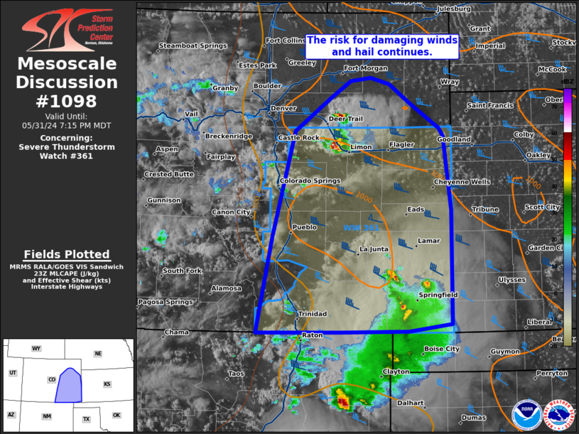
   Mesoscale Discussion 1098
   NWS Storm Prediction Center Norman OK
   0644 PM CDT Fri May 31 2024

   Areas affected...portions of eastern Colorado

   Concerning...Severe Thunderstorm Watch 361...

   Valid 312344Z - 010115Z

   The severe weather threat for Severe Thunderstorm Watch 361
   continues.

   SUMMARY...The severe risk continues across WW361 with the risk of
   damaging winds and hail. Storm coverage could increase this evening
   though storm evolution is uncertain.

   DISCUSSION...As of 2330, UTC regional observations showed widely
   scattered clusters of strong to occasional severe storms ongoing
   across parts of eastern/southeastern CO. Thus far, severe storm
   coverage has remained somewhat limited within a modifying
   post-frontal upslope flow regime. Still the environment remains
   broadly favorable for damaging gusts and hail with ~1000 J/kg of
   MLCAPE and 40-50 kt of effective shear over much of the watch areas.

   Later this evening into tonight, additional storm development will
   remain possible along the I-25 corridor. Numerous weak updrafts are
   present over the mountains and eastern foothills of the Rockies.
   Recent hi-res guidance and some observational trend suggest a few of
   these updrafts may eventually move east and mature with the onset of
   additional forcing from the nocturnal low-level jet. While
   conditional, severe storm coverage may increase in the next couple
   of hours and into the early overnight within the aforementioned
   favorable environment. Should this occur, hail and damaging winds
   appear likely, especially over northern and central portions of
   WW361. However, significant uncertainty in storm evolution remains.

   ..Lyons.. 05/31/2024

   ...Please see www.spc.noaa.gov for graphic product...

   ATTN...WFO...GLD...PUB...BOU...ABQ...

   LAT...LON   37000383 36980514 38200489 39520454 39920399 40140366
               40180334 40100304 39860270 39550225 39450217 38530205
               37090205 37010273 37000383
|
|
Top/All Mesoscale Discussions/Forecast Products/Home
|
|


 @NWSSPC