|
| Mesoscale Discussion 1129 |
|
< Previous MD Next MD >
|
|
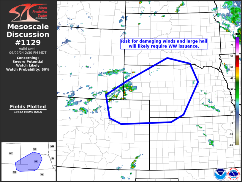
   Mesoscale Discussion 1129
   NWS Storm Prediction Center Norman OK
   0251 PM CDT Sun Jun 02 2024

   Areas affected...southeastern Wyoming...northeastern
   Colorado...western Nebraska and northwestern Kansas

   Concerning...Severe potential...Watch likely

   Valid 021951Z - 022030Z

   CORRECTED FOR GRAPHIC

   Probability of Watch Issuance...80 percent

   SUMMARY...Storms developing over the southeastern Wyoming vicinity
   should gradually increase/expand eastward/southeastward over the
   next couple of hours -- likely requiring WW issuance by 02/21z.

   DISCUSSION...Latest visible satellite imagery shows convection
   slowly increasing across the southeastern Wyoming, with growing TCU
   southward to the Palmer Divide.  This increase is occurring as
   ascent associated with weak short-wave troughing moving across
   Wyoming overspreads the area.  Recently, a stronger storm has
   initiated over Banner County in the Nebraska Panhandle, and -- while
   capping remains in place farther east -- this storm may note the
   initial stages of the anticipated afternoon/evening severe-weather
   event over western Nebraska and adjacent northwestern Kansas.

   Above the aforementioned capping inversion over western Nebraska and
   northwestern Kansas, steep lapse rates are contributing to 2000 to
   3000 J/kg mixed-layer CAPE.  As stronger mid-level westerly flow --
   associated with the aforementioned mid-level trough -- spreads
   eastward across the central High Plains, the overall environment
   will increasingly support potential for severe/supercell storms.
   Along with potential for very large hail, strong/damaging wind gusts
   are also expected locally -- aided by sub-cloud evaporation within
   the rather deeply mixed boundary layer.

   ..Goss/Smith.. 06/02/2024

   ...Please see www.spc.noaa.gov for graphic product...

   ATTN...WFO...FSD...GID...LBF...UNR...GLD...BOU...CYS...

   LAT...LON   41250536 42100374 43410068 43069890 42009833 40159950
               39740044 39600414 39930503 41250536
|
|
Top/All Mesoscale Discussions/Forecast Products/Home
|
|


 @NWSSPC