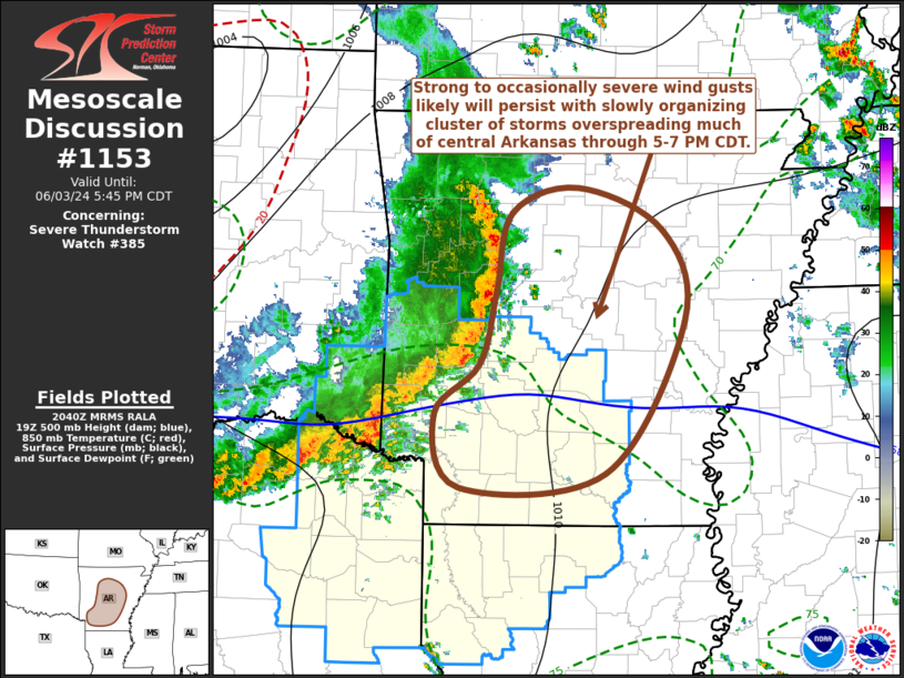
   Mesoscale Discussion 1153
   NWS Storm Prediction Center Norman OK
   0343 PM CDT Mon Jun 03 2024

   Areas affected...southwestern through central Arkansas

   Concerning...Severe Thunderstorm Watch 385...

   Valid 032043Z - 032245Z

   The severe weather threat for Severe Thunderstorm Watch 385
   continues.

   SUMMARY...A slowly organizing cluster of thunderstorms will
   overspread much of central Arkansas, including the Little Rock
   vicinity, through 5-7 PM CDT, with a continue risk for strong to
   occasionally severe wind gusts.  Trends will continue to be
   monitored for a possible additional watch downstream, WW 385 could
   be locally extended northeastward through central Arkansas.

   DISCUSSION...The ongoing cluster of storms has become a bit better
   organized, with a developing mesoscale convective vortex now east of
   Fort Smith, and 50 kt west-northwesterly rear inflow in the 1-3 km
   AGL layer evident on the Fort Smith VWP.  The leading edge of the
   convective outflow, and stronger convective development, is still
   advancing eastward at a relatively modest 30+ kt.  However,
   boundary-layer destabilization is ongoing immediately ahead of the
   outflow into central Arkansas, where 2-hourly surface pressure falls
   are maximized (around 3 mb) near Little Rock.  This could support at
   least some further intensification and acceleration into early
   evening.

   ..Kerr.. 06/03/2024

   ...Please see www.spc.noaa.gov for graphic product...

   ATTN...WFO...LZK...SHV...

   LAT...LON   33959395 34369348 34999331 35649315 35869248 35509162
               34729139 33449221 33329370 33959395
|


 @NWSSPC