|
| Mesoscale Discussion 1162 |
|
< Previous MD Next MD >
|
|
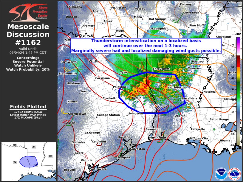
   Mesoscale Discussion 1162
   NWS Storm Prediction Center Norman OK
   1241 PM CDT Tue Jun 04 2024

   Areas affected...Far eastern Texas and western Louisiana

   Concerning...Severe potential...Watch unlikely

   Valid 041741Z - 041845Z

   Probability of Watch Issuance...20 percent

   SUMMARY...A thunderstorm complex near the TX/LA border will continue
   to slowly progress east-southeastward through this afternoon. A few
   stronger embedded thunderstorms on its western flank may produce
   marginally severe hail and localized damaging wind gusts.

   DISCUSSION...A remnant overnight thunderstorm complex is beginning
   to show signs of localized intensification on its western flank
   early this afternoon over east TX. In particular, latest infrared
   satellite imagery indicates cloud tops are cooling over Shelby and
   Nacogdoches Counties. This is also apparent in radar imagery. The
   convective environment near and just downstream of this system
   continues to destabilize, with surface temperatures now in the mid
   to upper 80s and dewpoints in the mid to upper 70s, under modest
   mid-level lapse rates. Although mid to upper flow is weak, large
   CAPE within the hail growth zone could support brief instances of
   marginally severe hail near 0.75-1.25". In addition, precipitation
   loading within merging clusters in a localized corridor of
   relatively steeper low level lapse rates may produce damaging wind
   gusts up to 60-65 mph. Considering the weaker aforementioned flow,
   narrow corridor of the severe threat, and lack of persistent storm
   organization, a WW does not appear likely at this time.

   ..Barnes/Smith.. 06/04/2024

   ...Please see www.spc.noaa.gov for graphic product...

   ATTN...WFO...LCH...SHV...HGX...FWD...

   LAT...LON   32049249 31689233 31199223 30839310 30809353 30829431
               31069488 31429529 31719530 32039509 32259478 32389433
               32449402 32419357 32359269 32049249
|
|
Top/All Mesoscale Discussions/Forecast Products/Home
|
|


 @NWSSPC