|
| Mesoscale Discussion 1163 |
|
< Previous MD Next MD >
|
|
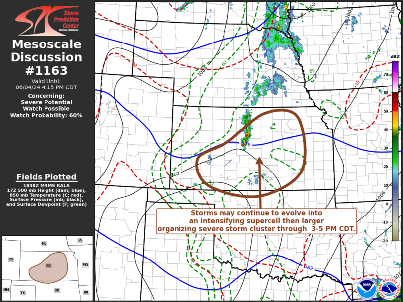
   Mesoscale Discussion 1163
   NWS Storm Prediction Center Norman OK
   0140 PM CDT Tue Jun 04 2024

   Areas affected...central and eastern Kansas

   Concerning...Severe potential...Watch possible

   Valid 041840Z - 042115Z

   Probability of Watch Issuance...60 percent

   SUMMARY...Storms may continue to evolve into an intensifying
   sustained supercell, then upscale growing and organizing
   thunderstorm cluster through 3-5 PM CDT.  A severe weather watch may
   be required within the next couple of hours.

   DISCUSSION...South of the primary trough within the stronger
   westerlies overspreading the northern Great Plains, a perturbation
   within weaker westerlies to the lee of the southern Rockies is in
   the process of overspreading the western Kansas through Texas
   Panhandle vicinity.  Just ahead of this feature, a persistent
   cluster of developing thunderstorms (now slowly progressing east of
   the Russell KS vicinity) has been focused near the northern
   periphery of a plume of very warm elevated mixed-layer air
   overspreading much of the southern Great Plains, likely aided by
   warm advection near the 700 mb level.  Beneath this regime,
   insolation within a boundary-layer characterized by seasonably high
   moisture content is becoming moderate to strongly unstable, with
   CAPE increasing in excess of 2000-3000 J/kg.

   It appears that the storms near Russell are undergoing a period of
   significant intensification with increasing inflow of this air now
   underway.  With the continued eastward progression of the upstream
   impulse, further suppression of inhibition associated with elevated
   mixed-layer may allow for a substantive further increase and upscale
   growth of convection through the 20-22Z time frame.

   Although convection is embedded within weak westerly deep-layer mean
   flow on the order of 10-20 kt, modest shear due to veering wind
   fields with height in lower to mid-levels may be sufficient to
   support a sustained intensifying supercell structure with increasing
   risk for large hail and some potential for a brief tornado.
   Eventually upscale growth may be accompanied by the evolution of a
   notable mesoscale convective vortex, strengthening mid-level rear
   inflow and increasing potential for strong to severe gusts with
   downward mixing to the surface.

   ..Kerr/Smith.. 06/04/2024

   ...Please see www.spc.noaa.gov for graphic product...

   ATTN...WFO...TOP...ICT...OUN...GID...DDC...

   LAT...LON   38110080 38739948 39799774 39629620 37709607 36799804
               37150028 38110080
|
|
Top/All Mesoscale Discussions/Forecast Products/Home
|
|


 @NWSSPC