|
| Mesoscale Discussion 1164 |
|
< Previous MD Next MD >
|

|
   Mesoscale Discussion 1164
   NWS Storm Prediction Center Norman OK
   0413 PM CDT Tue Jun 04 2024

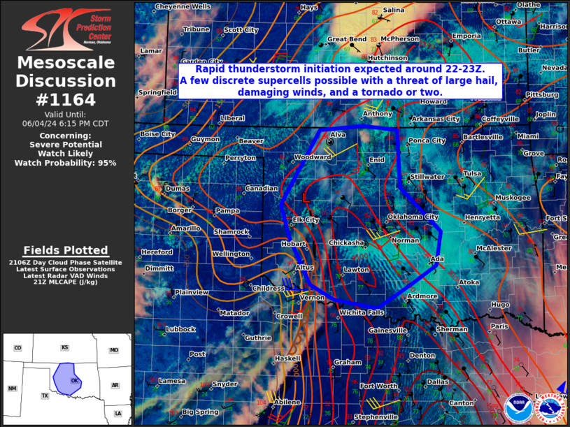
   Areas affected...Portions of central Oklahoma

   Concerning...Severe potential...Watch likely

   Valid 042113Z - 042315Z

   Probability of Watch Issuance...95 percent

   SUMMARY...Rapid thunderstorm initiation is expected within the next
   1-2 hours across portions of central Oklahoma. Large hail up to
   1.50-2.50" in diameter, wind gusts exceeding 65-75 mph, and perhaps
   a tornado or two are expected.

   DISCUSSION...Latest visible satellite imagery trends indicate air
   mass modification is continuing across north central and central OK
   late this afternoon. A developing cumulus field is apparent near a
   mesolow just north of I-40 and Clinton, OK. A surface trough and
   dryline extend southward from this low into portions of southwestern
   OK. An axis of extreme instability has developed within
   southeasterly surface winds on the western edge of a residual cold
   pool from earlier this morning. As destabilization continues, and
   cooler mid-level temps accompany a mid-level trough slowly
   progressing eastward over the northern half of OK early this
   evening, rapid thunderstorm development is expected near the surface
   low and convergence zones.

   Although very modest mid to upper flow should limit persistent,
   discrete storm organization, a few transient discrete supercells
   will remain possible via veering and increasing flow within the
   lowest 4 km of the troposphere. In addition, very large CAPE and
   steep lapse rates (~8.5 C/km) within the hail growth zone could
   support large hail with any of the discrete cells. Furthermore,
   localized enhanced 0-1 km SRH is expected near and south of I-40
   where surface 10-15 kt winds will likely remained backed increasing
   the potential for a tornado or two before storms begin to build
   upscale later this evening. Severe, damaging winds will become more
   likely by this time. A severe thunderstorm watch will be needed
   soon.

   ..Barnes/Smith.. 06/04/2024

   ...Please see www.spc.noaa.gov for graphic product...

   ATTN...WFO...TSA...ICT...OUN...DDC...

   LAT...LON   35209946 34439904 34199857 34059772 34469702 34749656
               35309646 36019726 36959731 37039800 36959886 35739964
               35209946
|
|
Top/All Mesoscale Discussions/Forecast Products/Home
|
|


