|
| Mesoscale Discussion 1178 |
|
< Previous MD Next MD >
|
|
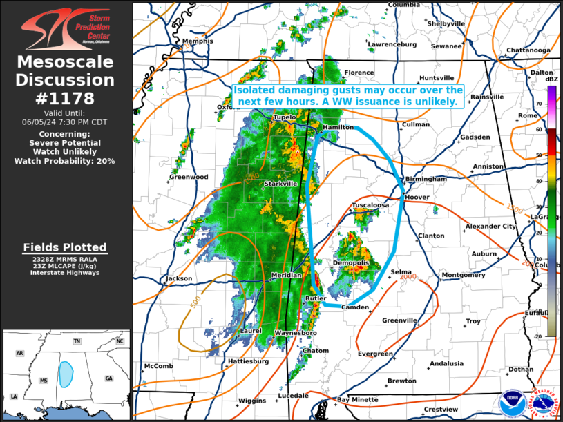
   Mesoscale Discussion 1178
   NWS Storm Prediction Center Norman OK
   0630 PM CDT Wed Jun 05 2024

   Areas affected...portions of western Alabama

   Concerning...Severe potential...Watch unlikely

   Valid 052330Z - 060030Z

   Probability of Watch Issuance...20 percent

   SUMMARY...A few strong wind gusts remain possible with a bowing
   linear segment for at least a couple more hours. However, the severe
   threat should remain isolated and a WW issuance is not expected.

   DISCUSSION...Multicellular convection, amid a weak shear
   environment, has managed to organize into a bowing segment, with
   tree damage recently reported in Jasper County, MS. This linear
   segment should continue to progress northeastward toward an unstable
   airmass (characterized by 2000+ J/kg MLCAPE) for at least a couple
   more hours. Until nocturnal cooling sets in, additional damaging
   gusts may accompany portions of the line. Nonetheless, the severe
   threat should remain isolated and a WW issuance is not expected.

   ..Squitieri/Bunting.. 06/05/2024

   ...Please see www.spc.noaa.gov for graphic product...

   ATTN...WFO...BMX...HUN...MOB...

   LAT...LON   32718694 32248725 32048759 32078792 32318808 32508809
               33488818 34088803 34168791 34208764 34188745 34048724
               33808700 33438681 32718694
|
|
Top/All Mesoscale Discussions/Forecast Products/Home
|
|


 @NWSSPC