|
| Mesoscale Discussion 1179 |
|
< Previous MD Next MD >
|

|
   Mesoscale Discussion 1179
   NWS Storm Prediction Center Norman OK
   0917 PM CDT Wed Jun 05 2024

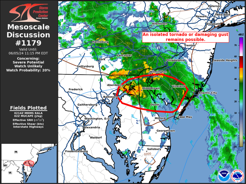
   Areas affected...far northeastern MD...northern DE and southern NJ

   Concerning...Severe potential...Watch unlikely

   Valid 060217Z - 060315Z

   Probability of Watch Issuance...20 percent

   SUMMARY...The ongoing cluster of storms near the MD/DE border may
   continue east with the risk for an isolated tornado or damaging gust
   this evening.

   DISCUSSION...As of 0210 UTC regional radar analysis showed a cluster
   of low topped storms near the MD/DE border. Thee storms have
   retained transient supercell characteristics near a subtle warm
   frontal zone across northern DelMarVa. Ahead of these storms, SPC
   mesoanalysis shows around 500-1000 J/kg of residual MUCAPE
   sufficient for continued updraft maintenance. Low-level shear
   remains favorable for some storm-scale rotation with KDOX VAD
   showing 0-1km SRH of 250-300 m2/s2. While storms have shown less
   intensity with time, the environment ahead of them remains
   conditionally favorable for a brief tornado or isolated damaging
   gusts for a couple more hours this evening. The exact eastward
   extent of the severe risk is uncertain as nocturnal stabilization
   has begun with the loss of diurnal heating. However, a very moist
   low-level environment (dewpoints in the 70s F) may slow
   stabilization and allow storms to remain near surface-based into
   parts of eastern DE and southern NJ.

   ..Lyons/Bunting.. 06/06/2024

   ...Please see www.spc.noaa.gov for graphic product...

   ATTN...WFO...PHI...LWX...

   LAT...LON   39137579 39227615 39357629 39507623 39647603 39717568
               39747525 39667496 39567474 39457464 39287476 39107488
               39067499 39057509 39077543 39137579
|
|
Top/All Mesoscale Discussions/Forecast Products/Home
|
|


