|
| Mesoscale Discussion 1180 |
|
< Previous MD Next MD >
|
|
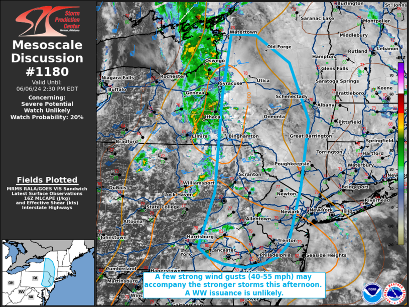
   Mesoscale Discussion 1180
   NWS Storm Prediction Center Norman OK
   1158 AM CDT Thu Jun 06 2024

   Areas affected...portions of eastern New York into eastern
   Pennsylvania and New Jersey

   Concerning...Severe potential...Watch unlikely

   Valid 061658Z - 061830Z

   Probability of Watch Issuance...20 percent

   SUMMARY...Thunderstorms are expected to increase in coverage and
   intensity through the afternoon across portions of the Hudson Valley
   into the Mid Atlantic. 40-55 mph wind gusts are the main threat with
   the stronger storms. 60+ mph gusts will likely be more isolated, so
   a WW issuance is not currently expected.

   DISCUSSION...Efficient diurnal heating is supporting the breach of
   convective temperatures (i.e. upper 70s/low 80s F) across portions
   of the Mid Atlantic, as a 500 mb vort max also approaches the Hudson
   Valley. MRMS mosaic radar data suggests that convective initiation
   appears underway across portions of central NY into central and
   eastern PA. These storms are developing amid a moist and heated
   low-level airmass, but with poor (5.5-6 C/km) tropospheric lapse
   rates. As such, the rate of increasing thunderstorm intensity will
   be strongly dependent on continued surface heating and further
   steepening of boundary layer lapse rates through the afternoon.
   Multicellular to perhaps transient supercellular storm modes are
   expected, as modest west-southwesterly mid-level flow atop weaker
   low-level winds will support small low-level hodographs, but with
   some mid-level elongation. Strong wind gusts in the 45-55 mph range
   (capable of localized damage) are expected with the stronger storms.
   However, the overall severe threat appears to be more isolated, so a
   WW issuance is not currently expected.

   ..Squitieri/Smith.. 06/06/2024

   ...Please see www.spc.noaa.gov for graphic product...

   ATTN...WFO...OKX...ALY...PHI...BGM...BUF...CTP...

   LAT...LON   40217445 39987471 39857503 39797548 39857599 39957632
               40147658 41137620 42897605 43997584 43977523 43477439
               42447393 41237414 40217445
|
|
Top/All Mesoscale Discussions/Forecast Products/Home
|
|


 @NWSSPC