|
| Mesoscale Discussion 1192 |
|
< Previous MD Next MD >
|
|
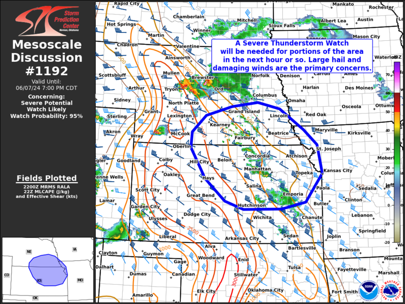
   Mesoscale Discussion 1192
   NWS Storm Prediction Center Norman OK
   0502 PM CDT Fri Jun 07 2024

   Areas affected...Portions of southeast NE...northeast KS...and far
   northwest MO

   Concerning...Severe potential...Watch likely

   Valid 072202Z - 080000Z

   Probability of Watch Issuance...95 percent

   SUMMARY...A Severe Thunderstorm Watch will likely be issued for
   portions of the area in the next hour or so. Primary concerns are
   large hail (some 2+ inches) and damaging winds (some 75+ mph).

   DISCUSSION...Several intense semi-discrete supercells are tracking
   southeastward across central NE this afternoon. These storms are
   evolving in an environment characterized by moderate surface-based
   instability and 45-55 kt of deep-layer shear (with ample clockwise
   hodograph curvature) per regional VWP data. Over the next several
   hours, this activity will generally continue tracking southeastward
   along the eastern edge of a northwest/southeast-oriented instability
   gradient. While downstream cloud coverage has stunted diurnal
   heating in some areas, temperatures have generally warmed into the
   mid/upper 80s amid middle 60s dewpoints. This should continue to
   support surface-based inflow as storms continue southeastward into
   tonight.

   Given the aforementioned wind profile, a semi-discrete supercell
   mode may persist initially, with large hail (some 2+ inches) and
   damaging winds possible. With time, a strengthening low-level jet
   may encourage upscale growth into severe larger supercell clusters
   and/or bowing segments, with an increasing risk of damaging winds
   (some 75+ mph). Evolution into a consolidated MCS is still unclear
   at this time, though this scenario would yield a greater wind risk.
   A Severe Thunderstorm Watch will likely be issued for parts of the
   area to cover this risk.

   ..Weinman/Bunting.. 06/07/2024

   ...Please see www.spc.noaa.gov for graphic product...

   ATTN...WFO...EAX...OAX...TOP...ICT...GID...DDC...GLD...

   LAT...LON   39919977 40389973 40899917 41189815 41319711 41109622
               40469527 39999476 39119458 38259524 38049619 38049767
               38299839 38969918 39919977
|
|
Top/All Mesoscale Discussions/Forecast Products/Home
|
|


 @NWSSPC