|
| Mesoscale Discussion 1193 |
|
< Previous MD Next MD >
|
|
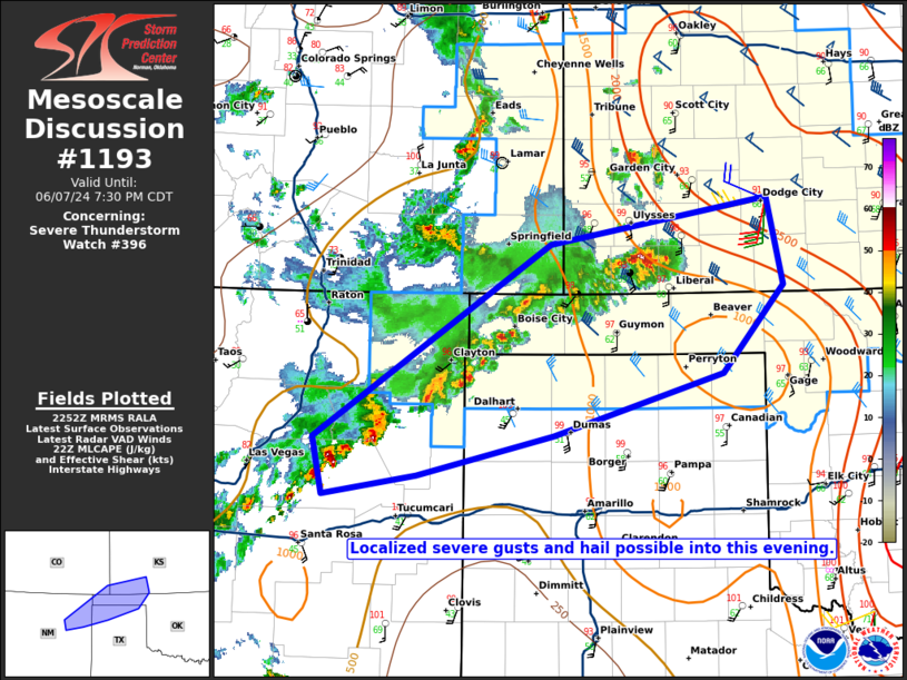
   Mesoscale Discussion 1193
   NWS Storm Prediction Center Norman OK
   0554 PM CDT Fri Jun 07 2024

   Areas affected...Southeast CO and extreme northeast NM into the
   OK/northern TX Panhandles and southwest KS

   Concerning...Severe Thunderstorm Watch 396...

   Valid 072254Z - 080030Z

   The severe weather threat for Severe Thunderstorm Watch 396
   continues.

   SUMMARY...The threat for isolated damaging wind and hail will spread
   eastward into this evening.

   DISCUSSION...Multiple loosely organized storm clusters are ongoing
   late this afternoon across parts of southeast CO, extreme northeast
   NM, and southwest KS. Convection is ongoing within a favorably
   sheared and rather hot and well-mixed environment, which will favor
   the potential for at least isolated severe gusts (as evidenced by a
   recent 55 kt gust in Clayton, NM) as storms spread eastward into the
   evening. The environment into southwest KS is somewhat more moist
   and unstable, and some isolated hail will be possible with the
   strongest storms in this region.

   CINH increases with eastward extent into eastern portions of the
   TX/OK Panhandles and southwest KS, so some uncertainty remains
   regarding how far east the severe threat will spread into the early
   evening. However, a short-term threat for isolated severe wind/hail
   remains evident across extreme southwest KS into the western/central
   TX/OK Panhandles and northeast NM.

   ..Dean.. 06/07/2024

   ...Please see www.spc.noaa.gov for graphic product...

   ATTN...WFO...OUN...DDC...AMA...PUB...ABQ...

   LAT...LON   35820213 35490351 35340447 35800456 37390216 37779996
               37059980 36330042 35820213
|
|
Top/All Mesoscale Discussions/Forecast Products/Home
|
|


 @NWSSPC